Difference between revisions of "2011-05-25 45 -121"
imported>Jiml m (Add result codes) |
imported>FippeBot m (Location) |
||
| (One intermediate revision by one other user not shown) | |||
| Line 47: | Line 47: | ||
Image:2011-05-25 45 -121 008 in the circle.jpg |But in the 20 ft circle is good enough. | Image:2011-05-25 45 -121 008 in the circle.jpg |But in the 20 ft circle is good enough. | ||
Image:2011-05-25 45 -121 009 fuzzy coord.jpg |Standing under one tree is about the same as the next. | Image:2011-05-25 45 -121 009 fuzzy coord.jpg |Standing under one tree is about the same as the next. | ||
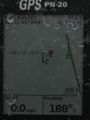
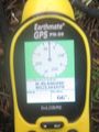
| − | Image:2011-05-25 45 -121 010 track. | + | Image:2011-05-25 45 -121 010 track.JPG |Sometimes I don't understand why the software does what it does. The pin '2011-05-25 hash' is the position that I entered, as a target. One way pt that I made as I arrived it labeled '2011-05-25 hash 002', and the next one it gave no label at all. WTF? |
Image:2011-05-25 45 -121 011 comming back out.jpg |It's good to see the car when you get back out. | Image:2011-05-25 45 -121 011 comming back out.jpg |It's good to see the car when you get back out. | ||
Image:2011-05-25 45 -121 012 Little White Salmon.jpg|Crossing the headwaters. | Image:2011-05-25 45 -121 012 Little White Salmon.jpg|Crossing the headwaters. | ||
| Line 59: | Line 59: | ||
[[Category:Expeditions with photos]] | [[Category:Expeditions with photos]] | ||
[[Category:Coordinates reached]] | [[Category:Coordinates reached]] | ||
| + | {{location|US|WA|SM}} | ||
Latest revision as of 06:39, 9 August 2019
| Wed 25 May 2011 in 45,-121: 45.8465524, -121.6611459 geohashing.info google osm bing/os kml crox |
Location
North of Willard(pop. 46),WA.
Participants
Plans
Before my morning visit with the dentist I checked the hash, & there it was.
Expedition
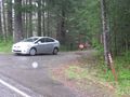
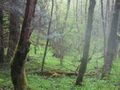
A scenic detour on the way home up Cook Underwood Rd got us past Willard, past Skamania Co.'s Big Cedars Park & then to NF080 Rd. Turn around there and park on the other side. Kate decided to sit and wait in the car, the hash was only about 350 ft into the rainy woods, and that was close enough for her. So in I go. I was having trouble keeping a 3D fix in the tree cover and drizzle. Up the hill a little and there I am.
Tracklog
I won't upload the file, but there is a screen capture of it from Topo8, the version of DeLorme's software that I use.
Photos
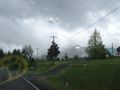
Gaining altitude off the Columbia.
Willard WA, pop 46. More of a lumber mill than a town.
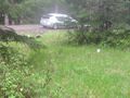
When you get to Rd 80 you have gone too far.
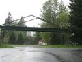
Some boys don't have enough sense to come in out of the rain.
So start walking.
One more time I didn't put myself in the photo.
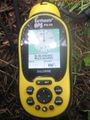
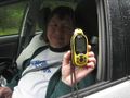
Bad DOP, my position kept drifting.
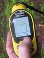
But in the 20 ft circle is good enough.
Standing under one tree is about the same as the next.

Sometimes I don't understand why the software does what it does. The pin '2011-05-25 hash' is the position that I entered, as a target. One way pt that I made as I arrived it labeled '2011-05-25 hash 002', and the next one it gave no label at all. WTF?
It's good to see the car when you get back out.
Crossing the headwaters.


Achievements
- Land geohash?