Difference between revisions of "2011-06-03 66 25"
From Geohashing
imported>Isopekka (Created page with "thumb|left {{meetup graticule | lat=66 | lon=25 | date=2011-06-03 }} == Location == 50 km to the S from the city Rovaniemi, on the fores...") |
imported>FippeBot m (Location) |
||
| (3 intermediate revisions by one other user not shown) | |||
| Line 12: | Line 12: | ||
== Location == | == Location == | ||
| − | 50 km to the S from the city Rovaniemi, | + | 50 km to the S from the city Rovaniemi, in the forest, in the village of Välijoki. |
== Participants == | == Participants == | ||
| Line 36: | Line 36: | ||
Image:Gh-2010-06-03-scrn.jpg| The Proof. | Image:Gh-2010-06-03-scrn.jpg| The Proof. | ||
Image:Gd+gh 2011-05-03 013.JPG| Another Proof. | Image:Gd+gh 2011-05-03 013.JPG| Another Proof. | ||
| − | Image:Gd+gh 2011-05-03 014.JPG| View | + | Image:Gd+gh 2011-05-03 014.JPG| View from the Hashpoint. |
Image:Gd+gh 2011-05-03 015.JPG| Hasher at the Hashpoint with broken left arm. | Image:Gd+gh 2011-05-03 015.JPG| Hasher at the Hashpoint with broken left arm. | ||
Image:Gd+gh 2011-05-03 017.JPG| Red marks on the way back. Maybe for snowscooter trail... | Image:Gd+gh 2011-05-03 017.JPG| Red marks on the way back. Maybe for snowscooter trail... | ||
| − | Image:Gd+gh 2011-05-03 018.JPG| Old dead school in Välijoki | + | Image:Gd+gh 2011-05-03 018.JPG| Old dead (or killed) school in the village of Välijoki, about 1 km from the Hash. |
Image:Gd+gh 2011-05-03 019.JPG| The schoolyard of the dead school. | Image:Gd+gh 2011-05-03 019.JPG| The schoolyard of the dead school. | ||
| Line 65: | Line 65: | ||
[[Category:Expeditions with photos]] | [[Category:Expeditions with photos]] | ||
[[Category:Coordinates reached]] | [[Category:Coordinates reached]] | ||
| + | {{location|FI|10}} | ||
Latest revision as of 06:45, 9 August 2019

| Fri 3 Jun 2011 in 66,25: 66.2445310, 25.8069657 geohashing.info google osm bing/os kml crox |
Contents
Location
50 km to the S from the city Rovaniemi, in the forest, in the village of Välijoki.
Participants
Expedition
- By car total 100 km
- Walking total 1.0 km
- Expedition took 2 h
- Physical effort (1-5): 3
Photos
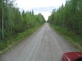
100 m forward along "the road 6", then 400 m to the left.

The Proof.
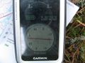
Another Proof.
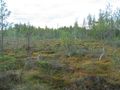
View from the Hashpoint.
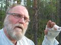
Hasher at the Hashpoint with broken left arm.
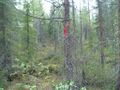
Red marks on the way back. Maybe for snowscooter trail...
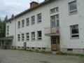
Old dead (or killed) school in the village of Välijoki, about 1 km from the Hash.
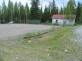
The schoolyard of the dead school.


Achievements
isopekka earned the Land geohash achievement
|
Geohashing Expeditions and Plans on This Day
Expeditions and Plans
| 2011-06-03 | ||
|---|---|---|
| Townsville, Australia | mattyk | In the city, not in any restricted military zones, and actually accessible!... |
| Rovaniemi, Finland | isopekka | 50 km to the S from the city Rovaniemi, in the forest, in the village of Vä... |