Difference between revisions of "2011-06-06 66 25"
From Geohashing
imported>Isopekka (Created page with "thumb|left {{meetup graticule | lat=66 | lon=25 | date=2011-06-06 }} == Location == 13 km to the N from my home, in the forest near the road, ...") |
imported>FippeBot m (Location) |
||
| (4 intermediate revisions by one other user not shown) | |||
| Line 36: | Line 36: | ||
<gallery perrow=4> | <gallery perrow=4> | ||
| − | Image:06-06-2011 014.JPG| 25 m to the left. Can you see the river "Ounasjoki" at the background? | + | Image:06-06-2011 014.JPG| The Hash situates in the forest 25 m to the left from the road. Can you see the river "Ounasjoki" at the background? |
Image:06-06-2011 015.JPG| Nice path. | Image:06-06-2011 015.JPG| Nice path. | ||
Image:06-06-2011 016.JPG| At the hashpoint. | Image:06-06-2011 016.JPG| At the hashpoint. | ||
| Line 59: | Line 59: | ||
| name = isopekka | | name = isopekka | ||
}} | }} | ||
| + | |||
| Line 70: | Line 71: | ||
[[Category:Expeditions with photos]] | [[Category:Expeditions with photos]] | ||
[[Category:Coordinates reached]] | [[Category:Coordinates reached]] | ||
| + | {{location|FI|10}} | ||
Latest revision as of 06:46, 9 August 2019

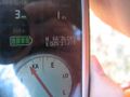
| Mon 6 Jun 2011 in 66,25: 66.6013823, 25.6203366 geohashing.info google osm bing/os kml crox |
Contents
Location
13 km to the N from my home, in the forest near the road, in the village of Vesalanperä, near the hill Nuuksvaara.
Participants
- isopekka and the son.
Expedition
- By car total 26km
- Walking total 0.05 km
- Expedition took 1 h
- Physical effort (1-5): 1
Photos
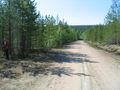
The Hash situates in the forest 25 m to the left from the road. Can you see the river "Ounasjoki" at the background?
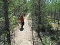
Nice path.
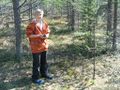
At the hashpoint.
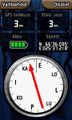
The proof.
Another proof.
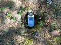
Hash-hole on the ground.
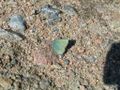
Callophrys rubi on the road.
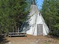
The Lappish shelter near the hash.
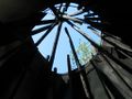
Heaven as seen from the shelter.


Achievements
isopekka earned the Land geohash achievement
|
Geohashing Expeditions and Plans on This Day
Expeditions and Plans
| 2011-06-06 | ||
|---|---|---|
| Rovaniemi, Finland | isopekka, the son. | 13 km to the N from my home, in the forest near the road, in the village of... |