Difference between revisions of "2011-06-26 27 -81"
imported>Rhonda (→Expedition) |
m (per Renaming Proposal) |
||
| (6 intermediate revisions by 3 users not shown) | |||
| Line 30: | Line 30: | ||
The drive out to Circle B Bar Reserve was easy, and the reserve's parking lot was just a few hundred metres away from the hashpoint. An electric tram tour was just departing as I walked up at 9AM, carrying my cameras. I picked up the last trail map in the outside pamphlet holders, chatted briefly with the lady who worked there, and headed along the trail going in the right direction. | The drive out to Circle B Bar Reserve was easy, and the reserve's parking lot was just a few hundred metres away from the hashpoint. An electric tram tour was just departing as I walked up at 9AM, carrying my cameras. I picked up the last trail map in the outside pamphlet holders, chatted briefly with the lady who worked there, and headed along the trail going in the right direction. | ||
| − | It turns out that the road displayed on google maps is a service road for the reserve; the hiking trail goes right through the stand of trees containing the hashpoint. It was not a stand of trees with underbrush, but a stand of widely spaced trees with | + | It turns out that the road displayed on google maps is a service road for the reserve; the hiking trail goes right through the stand of trees containing the hashpoint. It was not a stand of trees with underbrush, but a stand of widely spaced trees with grass and other small, non-obstructive plants growing between them. I walked in circles for a minute or so to get a zero on my GPS, then took some pictures. |
Then I started looking for the [http://www.geocaching.com/seek/cache_details.aspx?wp=GCPBGY geocache which I knew was nearby]. It was, as predicted, absurdly close, maybe 5 metres away, and the container was easy to spot once you were in the right place - just around the other side of the tree. | Then I started looking for the [http://www.geocaching.com/seek/cache_details.aspx?wp=GCPBGY geocache which I knew was nearby]. It was, as predicted, absurdly close, maybe 5 metres away, and the container was easy to spot once you were in the right place - just around the other side of the tree. | ||
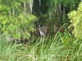
| − | Once I finished documenting the geohash, I wandered down the hiking trail named "alligator alley" but didn't see any gators there, only warning signs. The "marsh rabbit" trail was closed due to alligators, so that's probably where they all were. I did see one young gator hanging out on a log, and a bunch of birds, including the biggest [http://identify.whatbird.com/obj/31/_/Great_Blue_Heron.aspx great blue heron] I've ever seen, and a whole flock of bright white [http://identify.whatbird.com/obj/30/_/Great_Egret.aspx egrets], which were by far the easiest birds to spot. I'm not a birder, so I don't know what all I saw, for the most part. | + | [[File:2011-06-26 27 -81 young gator.jpg|300px|thumb|right|alligator!]] |
| + | Once I finished documenting the geohash, I wandered down the hiking trail named "alligator alley" but didn't see any gators there, only warning signs. The "marsh rabbit" trail was closed due to alligators, so that's probably where they all were. On a different trail, I did see one young gator hanging out on a log, and a bunch of birds, including the biggest [http://identify.whatbird.com/obj/31/_/Great_Blue_Heron.aspx great blue heron] I've ever seen, and a whole flock of bright white [http://identify.whatbird.com/obj/30/_/Great_Egret.aspx egrets], which were by far the easiest birds to spot. I'm not a birder, so I don't know what all I saw, for the most part. | ||
I wandered through the displays once the buildings opened at noon (very nice of them to open the trails early) and left about a half hour later. It was an easy geohash and a fun way to spend a morning. (Also, if I'm still here during the bird migration, I think I'll go back... apparently there aren't actually a lot of birds there right now.) | I wandered through the displays once the buildings opened at noon (very nice of them to open the trails early) and left about a half hour later. It was an easy geohash and a fun way to spend a morning. (Also, if I'm still here during the bird migration, I think I'll go back... apparently there aren't actually a lot of birds there right now.) | ||
| Line 42: | Line 43: | ||
Image:2010-##-## ## ## Alpha.jpg | Witty Comment | Image:2010-##-## ## ## Alpha.jpg | Witty Comment | ||
--> | --> | ||
| − | <gallery | + | <gallery> |
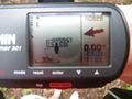
| + | Image:2011-06-26 27 -81 gps.jpg | 0m from hashpoint! | ||
| + | Image:2011-06-26 27 -81 smile and sophie.JPG | It's the Rhonda and Sophie team! | ||
| + | Image:2011-06-26 27 -81 at hashpoint.jpg | Standing on the hashpoint, looking at the geocache location | ||
| + | Image:2011-06-26 27 -81 Cache.JPG | Yup, there's the cache | ||
| + | Image:2011-06-26 27 -81 bug.jpg | Don't kneel on the bug to get the cache! I put my knee beside it instead. | ||
| + | Image:2011-06-26 27 -81 inside cache.JPG | The usual geocaching stuff inside. | ||
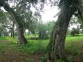
| + | Image:2011-06-26 27 -81 view from trail.jpg | From the hiking trail, the hash and the cache. | ||
| + | Image:2011-06-26 27 -81 archway.JPG | On to the rest of the hike | ||
| + | Image:2011-06-26 27 -81 Warning.JPG | There <del>might</del> ''will'' be alligators! | ||
| + | Image:2011-06-26 27 -81 young gator.jpg | But this was the only one I saw. | ||
| + | Image:2011-06-26 27 -81 Heron.JPG | Quite a few great blue herons. I didn't get a good picture of the really big one. | ||
</gallery> | </gallery> | ||
| Line 48: | Line 60: | ||
{{#vardefine:ribbonwidth|800px}} | {{#vardefine:ribbonwidth|800px}} | ||
<!-- Add any achievement ribbons you earned below, or remove this section --> | <!-- Add any achievement ribbons you earned below, or remove this section --> | ||
| + | {{Hash collision | ||
| + | | latitude = 27 | ||
| + | | longitude = -81 | ||
| + | | date = 2011-06-26 | ||
| + | | name = Rhonda | ||
| + | | id = GCPBGY | ||
| + | | link = http://www.geocaching.com/seek/cache_details.aspx?wp=GCPBGY | ||
| + | | distance = about 5m | ||
| + | | image = 2011-06-26 27 -81 view from trail.jpg | ||
| + | }} | ||
| + | {{Graticule unlocked | ||
| + | | latitude = 27 | ||
| + | | longitude = -81 | ||
| + | | date = 2011-06-26 | ||
| + | | name = Rhonda | ||
| + | | image = 2011-06-26 27 -81 smile and sophie.JPG | ||
| + | }} | ||
| − | |||
| − | |||
| − | |||
| − | |||
| − | |||
| − | |||
| − | |||
| − | |||
[[Category:Expeditions]] | [[Category:Expeditions]] | ||
| − | |||
[[Category:Expeditions with photos]] | [[Category:Expeditions with photos]] | ||
| − | |||
| − | |||
| − | |||
| − | |||
| − | |||
[[Category:Coordinates reached]] | [[Category:Coordinates reached]] | ||
| − | + | {{location|US|FL|PO}} | |
| − | |||
| − | |||
| − | |||
| − | |||
| − | |||
| − | |||
| − | |||
| − | |||
| − | |||
Latest revision as of 05:53, 20 March 2024
| Sun 26 Jun 2011 in 27,-81: 27.9888553, -81.8545154 geohashing.info google osm bing/os kml crox |
Location
Circle B Bar Nature Reserve, in some trees off a trail. May or may not be accessible, but it's a good kick in the pants to go check out that park! And if nothing else, I can take pictures of stuff.
Participants
Plans
Find out when they open (5AM). Go early so the weather isn't disgustingly hot. Decide whether to bike or drive (24km each way, returning when it's much hotter). Bring cameras.
Updated plans: there's a geocache there. And by that I mean, right there. How far is 0.2 seconds? Because that's how close it is. Also, the reserve is supportive of geocaching, so they should be fine with people walking in circles staring at their GPS just off a trail. This just keeps getting better.
Expedition
My decision on whether to cycle or drive was made for me by my FL bike; I had the tires inflated Friday evening, rode it to a 5k race Saturday morning, and Saturday afternoon the front tire was soft. This morning it was flat. So, driving it is. (And a new inner tube is now in the cards for this bike. Probably will cost as much as the bike did.)
It was overcast and muggy, but didn't seem as hot as it had been the previous week. I put on sunscreen anyway.
The drive out to Circle B Bar Reserve was easy, and the reserve's parking lot was just a few hundred metres away from the hashpoint. An electric tram tour was just departing as I walked up at 9AM, carrying my cameras. I picked up the last trail map in the outside pamphlet holders, chatted briefly with the lady who worked there, and headed along the trail going in the right direction.
It turns out that the road displayed on google maps is a service road for the reserve; the hiking trail goes right through the stand of trees containing the hashpoint. It was not a stand of trees with underbrush, but a stand of widely spaced trees with grass and other small, non-obstructive plants growing between them. I walked in circles for a minute or so to get a zero on my GPS, then took some pictures.
Then I started looking for the geocache which I knew was nearby. It was, as predicted, absurdly close, maybe 5 metres away, and the container was easy to spot once you were in the right place - just around the other side of the tree.

Once I finished documenting the geohash, I wandered down the hiking trail named "alligator alley" but didn't see any gators there, only warning signs. The "marsh rabbit" trail was closed due to alligators, so that's probably where they all were. On a different trail, I did see one young gator hanging out on a log, and a bunch of birds, including the biggest great blue heron I've ever seen, and a whole flock of bright white egrets, which were by far the easiest birds to spot. I'm not a birder, so I don't know what all I saw, for the most part.
I wandered through the displays once the buildings opened at noon (very nice of them to open the trails early) and left about a half hour later. It was an easy geohash and a fun way to spend a morning. (Also, if I'm still here during the bird migration, I think I'll go back... apparently there aren't actually a lot of birds there right now.)
Photos
0m from hashpoint!

It's the Rhonda and Sophie team!
Standing on the hashpoint, looking at the geocache location
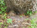
Yup, there's the cache
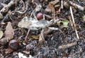
Don't kneel on the bug to get the cache! I put my knee beside it instead.

The usual geocaching stuff inside.
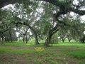
From the hiking trail, the hash and the cache.
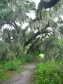
On to the rest of the hike
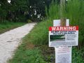
There
mightwill be alligators!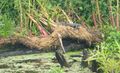
But this was the only one I saw.
Quite a few great blue herons. I didn't get a good picture of the really big one.


Achievements
Rhonda earned the Hash collision achievement
|
Rhonda earned the Graticule Unlocked Achievement
|