Difference between revisions of "2011-06-26 49 8"
imported>Mampfred (Created page with "{{subst:Expedition |lat = 49 |lon = 8 |date = 2011-06-26 }}") |
imported>FippeBot m (Location) |
||
| (5 intermediate revisions by one other user not shown) | |||
| Line 1: | Line 1: | ||
| − | |||
| − | |||
| − | |||
| − | |||
| − | |||
| − | |||
| − | |||
| − | |||
| − | |||
| − | |||
{{meetup graticule | {{meetup graticule | ||
| lat=49 | | lat=49 | ||
| Line 15: | Line 5: | ||
}} | }} | ||
| − | |||
__NOTOC__ | __NOTOC__ | ||
== Location == | == Location == | ||
| − | + | On a field near Rodgau. | |
== Participants == | == Participants == | ||
| − | + | *[[User:Mampfred|Mampfred]] | |
| + | *[[User:LadyBB|LadyBB]] (+MJ) | ||
== Plans == | == Plans == | ||
| − | + | The hash gods must have a very good week. LadyBB and Mampfred spent a couple of days on a seminar in a hotel in Rodgau. And not only did we pass [[2011-06-23 49 8|last thursdays hash]] on our way there, todays hash on the way back is only 2.2km from the hotel. Can't not do it. | |
== Expedition == | == Expedition == | ||
| − | + | We parked in front of a little restaurant near the hash. Beautiful weather, very hot and sunny. We walked a couple of hundred meters along the road and then turned and entered the fields next to it. Fortunately most of the fields only had grass on them, so we easily reached the hash, took some photos and went back to the car. | |
== Tracklog == | == Tracklog == | ||
| − | + | See [http://www.everytrail.com/view_trip.php?trip_id=1160202 here]. | |
== Photos == | == Photos == | ||
| − | |||
| − | |||
| − | |||
<gallery perrow="5"> | <gallery perrow="5"> | ||
| + | Image:2011-06-26_49_8_parking.jpg | Carpark. | ||
| + | Image:2011-06-26_49_8_reiber_kreisel.jpg | A roundabout called the "Reiber Kreisel" ... | ||
| + | Image:2011-06-26_49_8_spirally.jpg | ... with a giant spring in the middle. | ||
| + | Image:2011-06-26_49_8_cock.jpg | Guarded by a huge cock. | ||
| + | Image:2011-06-26_49_8_this_way.jpg | This way to the hash. | ||
| + | Image:2011-06-26_49_8_coordinates.jpg | Coordinates ... | ||
| + | Image:2011-06-26_49_8_reached.jpg | ... reached. | ||
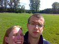
| + | Image:2011-06-26_49_8_mampfred.jpg | Mampfred and the hash. | ||
| + | Image:2011-06-26_49_8_grinwork.jpg | No, let's try again. | ||
| + | Image:2011-06-26_49_8_grin.jpg | Grin + Stupid. | ||
</gallery> | </gallery> | ||
== Achievements == | == Achievements == | ||
{{#vardefine:ribbonwidth|800px}} | {{#vardefine:ribbonwidth|800px}} | ||
| − | + | {{Land geohash | |
| + | | latitude = 49 | ||
| + | | longitude = 8 | ||
| + | | date = 2011-06-26 | ||
| + | | name = LadyBB and Mampfred | ||
| + | }} | ||
| − | |||
| − | |||
| − | |||
| − | |||
| − | |||
| − | |||
| − | |||
| − | |||
| − | |||
| − | |||
| − | |||
[[Category:Expeditions]] | [[Category:Expeditions]] | ||
| − | |||
[[Category:Expeditions with photos]] | [[Category:Expeditions with photos]] | ||
| − | |||
| − | |||
| − | |||
| − | |||
| − | |||
[[Category:Coordinates reached]] | [[Category:Coordinates reached]] | ||
| − | + | {{location|DE|HE|OF}} | |
| − | |||
| − | |||
| − | |||
| − | |||
| − | |||
| − | |||
| − | |||
| − | |||
| − | |||
Latest revision as of 06:55, 9 August 2019
| Sun 26 Jun 2011 in 49,8: 49.9888553, 8.8545154 geohashing.info google osm bing/os kml crox |
Location
On a field near Rodgau.
Participants
Plans
The hash gods must have a very good week. LadyBB and Mampfred spent a couple of days on a seminar in a hotel in Rodgau. And not only did we pass last thursdays hash on our way there, todays hash on the way back is only 2.2km from the hotel. Can't not do it.
Expedition
We parked in front of a little restaurant near the hash. Beautiful weather, very hot and sunny. We walked a couple of hundred meters along the road and then turned and entered the fields next to it. Fortunately most of the fields only had grass on them, so we easily reached the hash, took some photos and went back to the car.
Tracklog
See here.
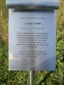
Photos
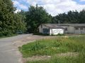
Carpark.
A roundabout called the "Reiber Kreisel" ...
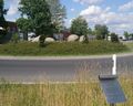
... with a giant spring in the middle.
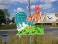
Guarded by a huge cock.
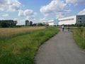
This way to the hash.
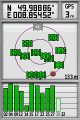
Coordinates ...
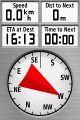
... reached.
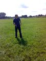
Mampfred and the hash.
No, let's try again.
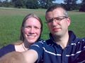
Grin + Stupid.


Achievements
LadyBB and Mampfred earned the Land geohash achievement
|