Difference between revisions of "2011-07-01 44 -87"
imported>Bassoon (Created page with "{{subst:Expedition |lat = 44 |lon = -87 |date = 2011-07-01 }}") |
imported>Bassoon |
||
| Line 1: | Line 1: | ||
| − | |||
| − | |||
| − | |||
| − | |||
| − | |||
| − | |||
| − | |||
| − | |||
| − | |||
| − | |||
{{meetup graticule | {{meetup graticule | ||
| lat=44 | | lat=44 | ||
| Line 15: | Line 5: | ||
}} | }} | ||
| − | |||
| − | |||
== Location == | == Location == | ||
| − | + | In a field between two highways near Luxemburg, WI. (Not Luxembourg, WI. Apparently there's a difference.) | |
== Participants == | == Participants == | ||
| − | + | [[User:Bassoon|Bassoon]] | |
| + | [[User:Dedehawk|Dedehawk]] | ||
== Plans == | == Plans == | ||
| − | + | Show up, walk to the hash, take a few photos, move to a safer park, and then have a picnic. | |
== Expedition == | == Expedition == | ||
| − | + | It really started on Wednesday, June 29. Bassoon reminded Dedehawk that their first hashiversary was coming up on Friday and that she should keep the day open for zany hashing antics. From there, their plans grew larger and larger until they realized that everything was tentative. The hash gods would have to smile upon them if they were to celebrate their hashiversary successfully. | |
| + | |||
| + | Luckily, the hash gods were happy when the Dow opened on Friday morning. The hashes in seven of the eight surrounding graticules were bad, as well as the home graticule's hash, but the northeastern graticule's...well, that one was just fine. And it was also a virgin, and the only square left to complete Minesweeper. | ||
| + | |||
| + | They could hardly say no. So when they were clear of their Friday obligations, the two of them set off to celebrate their hashiversary in the best way possible: with a picnic. | ||
| + | |||
| + | They left around 4:50 from Dedehawk's house and set off. Minor construction was encountered on I-43 heading north to Green Bay, but other than that, it was smooth sailing. A little south of Manitowoc, Bassoon spotted the exit sign for the [[2010-08-21_44_-87|previous (failed) Manitowoc hash]] near St. Nazianz, which he had kindly dubbed "Saint Nasty-Ass." That was about halfway there. | ||
| + | |||
| + | They gassed up and soon the Green Bay was in view. Not the city, of course, but the bay itself. Dedehawk and Bassoon were excited. They had never been to Door county before. As they exited I-43 and started on Highway 57, the anticipation mounted. They even blew past the sign advertising the statue of Jean Nicolet at the side of the road. How dedicated! | ||
| + | |||
| + | Once they arrived in the vicinity at the hash, Bassoon pulled the car over and parked in a disused field entrance. He and Dedehawk left the vehicle and started walking up the road to the hash, which was in the field between County Highway DK and Highway 57. As they blazed the trail through the grass, Bassoon realized his fear of ticks once more. Oh god, ticks. How awful. | ||
| + | |||
| + | Because Highway 57 was a state highway, it was fenced in, which effectively blocked travel to the hashpoint. It would be illegal (and highly dangerous) to progress beyond the fence. However, Bassoon and Dedehawk were only around 8 meters from the point, so they decided to declare victory and take the requisite photos. When they went to photograph Bassoon's GPS/Phone, however... | ||
| + | |||
| + | Oh yeah. Bassoon's GPS/Phone is the worst piece of technology in the history of time. It overheated. Three times. While they waited for the GPS/Phone to cooperate long enough to verify position, they took photographs. The fence was pretty cool. Once the GPS/Phone was functional again, Bassoon and Dedehawk made their Stupid Grins, verified the location, and headed back to the car. There was a park nearby to relocate to where they could have their hashiversary picnic. Who wants to have a picnic in the margins of two highways where exhaust fumes and thousands upon thousands of bugs would ruin their appetites? | ||
| + | |||
| + | Once they arrived, they set up their pic-a-nic blanket in the grass by the shores of Green Bay. The sun was just starting to set, so nature was putting on a beautiful show. After finishing the SAMMICHES and eating some Bugles, the cake was unveiled. Purchased earlier that day, the cake boldly read "Happy Geo-hashiversary!" in orange, accented with rainbow confetti; black, purple, and blue icing; Mexican candles (including two maracas, a sombrero, a cactus, and a chili pepper wearing a sombrero); and Mexican flags. Bassoon and Dedehawk set off devouring the cake. | ||
| − | + | After eating, Bassoon and Dedehawk watched the sun set on the successful day of geohashing. The drive home was subsequently uneventful, but that was okay. It had been a great day. | |
| − | |||
== Photos == | == Photos == | ||
| − | |||
| − | |||
| − | |||
<gallery perrow="5"> | <gallery perrow="5"> | ||
| + | Image:2011-07-01 44 -87 phonehate.png | Bassoon hates his freaking GPS/Phone. So much. | ||
| + | Image:2011-07-01 44 -87 stupidgrins.png | The stupidest of grins. | ||
| + | Image:2011-07-01 44 -87 coolfence.png | Pretty cool fence pattern while GPS/Phone was on the fritz. | ||
| + | Image:2011-07-01 44 -87 coords.png | Here we are! Without the background map! | ||
| + | Image:2011-07-01 44 -87 SAMMICHES.png | Delicious SAMMICHES. | ||
| + | Image:2011-07-01 44 -87 victorycake.png | Sweet, sweet victorycaek. | ||
| + | Image:2011-07-01_44_-87_lakepicnic.png | A picnic by the lake. | ||
</gallery> | </gallery> | ||
== Achievements == | == Achievements == | ||
{{#vardefine:ribbonwidth|800px}} | {{#vardefine:ribbonwidth|800px}} | ||
| − | + | {{land geohash | |
| − | + | | latitude = 44 | |
| − | + | | longitude = -87 | |
| − | + | | date = 2011-07-01 | |
| − | + | | name = Bassoon and Dedehawk | |
| − | + | | image = 2011-07-01 44 -87 coords.png | |
| − | + | }} | |
| − | + | {{Hashiversary | |
| − | + | | new = 2011-07-01_44_-87 | |
| − | + | | original = 2010-07-01_43_-88 | |
| − | + | | ordinal = 1st | |
| + | | name = Bassoon and Dedehawk | ||
| + | | gender = their | ||
| + | | image = 2011-07-01_44_-87_victorycake.png | ||
| + | }} | ||
| + | {{Virgin graticule | ||
| + | | latitude = 44 | ||
| + | | longitude = -87 | ||
| + | | date = 2011-07-01 | ||
| + | | name = Bassoon and Dedehawk | ||
| + | | image = 2011-07-01 44 -87 stupidgrins.png | ||
| + | }} | ||
| + | {{Picnic_geohash | ||
| + | | latitude = 44 | ||
| + | | longitude = -87 | ||
| + | | date = 2011-07-01 | ||
| + | | name = Bassoon and Dedehawk | ||
| + | | image = 2011-07-01 44 -87 SAMMICHES.png | ||
| + | | food = SAMMICHES, Bugles, and sweet, sweet victorycaek | ||
| + | }} | ||
| + | {{Minesweeper geohash | ||
| + | | graticule = Fond Du Lac, Wisconsin | ||
| + | | ranknumber = 8 | ||
| + | | n = true | ||
| + | | ne = true | ||
| + | | e = true | ||
| + | | se = true | ||
| + | | s = true | ||
| + | | sw = true | ||
| + | | w = true | ||
| + | | nw = true | ||
| + | | name = Bassoon and Dedehawk (optional) | ||
| + | }} | ||
| + | {{A Tale of Two Hashes challenge | ||
| + | | latitude = 44 | ||
| + | | longitude = -87 | ||
| + | | date = 2011-07-01 | ||
| + | | name = Bassoon and Dedehawk | ||
| + | | place = Luxemburg (or Luxembourg) | ||
| + | }} | ||
| − | |||
[[Category:Expeditions]] | [[Category:Expeditions]] | ||
| − | |||
[[Category:Expeditions with photos]] | [[Category:Expeditions with photos]] | ||
| − | + | ||
| − | |||
| − | |||
| − | |||
| − | |||
[[Category:Coordinates reached]] | [[Category:Coordinates reached]] | ||
| − | |||
| − | |||
| − | |||
| − | |||
| − | |||
| − | |||
| − | |||
| − | |||
| − | |||
| − | |||
Revision as of 05:36, 2 July 2011
| Fri 1 Jul 2011 in 44,-87: 44.6608733, -87.7462145 geohashing.info google osm bing/os kml crox |
Location
In a field between two highways near Luxemburg, WI. (Not Luxembourg, WI. Apparently there's a difference.)
Participants
Plans
Show up, walk to the hash, take a few photos, move to a safer park, and then have a picnic.
Expedition
It really started on Wednesday, June 29. Bassoon reminded Dedehawk that their first hashiversary was coming up on Friday and that she should keep the day open for zany hashing antics. From there, their plans grew larger and larger until they realized that everything was tentative. The hash gods would have to smile upon them if they were to celebrate their hashiversary successfully.
Luckily, the hash gods were happy when the Dow opened on Friday morning. The hashes in seven of the eight surrounding graticules were bad, as well as the home graticule's hash, but the northeastern graticule's...well, that one was just fine. And it was also a virgin, and the only square left to complete Minesweeper.
They could hardly say no. So when they were clear of their Friday obligations, the two of them set off to celebrate their hashiversary in the best way possible: with a picnic.
They left around 4:50 from Dedehawk's house and set off. Minor construction was encountered on I-43 heading north to Green Bay, but other than that, it was smooth sailing. A little south of Manitowoc, Bassoon spotted the exit sign for the previous (failed) Manitowoc hash near St. Nazianz, which he had kindly dubbed "Saint Nasty-Ass." That was about halfway there.
They gassed up and soon the Green Bay was in view. Not the city, of course, but the bay itself. Dedehawk and Bassoon were excited. They had never been to Door county before. As they exited I-43 and started on Highway 57, the anticipation mounted. They even blew past the sign advertising the statue of Jean Nicolet at the side of the road. How dedicated!
Once they arrived in the vicinity at the hash, Bassoon pulled the car over and parked in a disused field entrance. He and Dedehawk left the vehicle and started walking up the road to the hash, which was in the field between County Highway DK and Highway 57. As they blazed the trail through the grass, Bassoon realized his fear of ticks once more. Oh god, ticks. How awful.
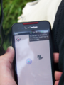
Because Highway 57 was a state highway, it was fenced in, which effectively blocked travel to the hashpoint. It would be illegal (and highly dangerous) to progress beyond the fence. However, Bassoon and Dedehawk were only around 8 meters from the point, so they decided to declare victory and take the requisite photos. When they went to photograph Bassoon's GPS/Phone, however...
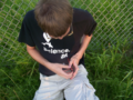
Oh yeah. Bassoon's GPS/Phone is the worst piece of technology in the history of time. It overheated. Three times. While they waited for the GPS/Phone to cooperate long enough to verify position, they took photographs. The fence was pretty cool. Once the GPS/Phone was functional again, Bassoon and Dedehawk made their Stupid Grins, verified the location, and headed back to the car. There was a park nearby to relocate to where they could have their hashiversary picnic. Who wants to have a picnic in the margins of two highways where exhaust fumes and thousands upon thousands of bugs would ruin their appetites?
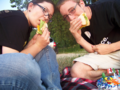
Once they arrived, they set up their pic-a-nic blanket in the grass by the shores of Green Bay. The sun was just starting to set, so nature was putting on a beautiful show. After finishing the SAMMICHES and eating some Bugles, the cake was unveiled. Purchased earlier that day, the cake boldly read "Happy Geo-hashiversary!" in orange, accented with rainbow confetti; black, purple, and blue icing; Mexican candles (including two maracas, a sombrero, a cactus, and a chili pepper wearing a sombrero); and Mexican flags. Bassoon and Dedehawk set off devouring the cake.
After eating, Bassoon and Dedehawk watched the sun set on the successful day of geohashing. The drive home was subsequently uneventful, but that was okay. It had been a great day.
Photos
Bassoon hates his freaking GPS/Phone. So much.

The stupidest of grins.
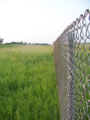
Pretty cool fence pattern while GPS/Phone was on the fritz.
Here we are! Without the background map!
Delicious SAMMICHES.

Sweet, sweet victorycaek.
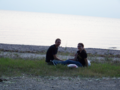
A picnic by the lake.


Achievements
Bassoon and Dedehawk earned the Land geohash achievement
|
Bassoon and Dedehawk earned the 1st Hashiversary achievement
|
Bassoon and Dedehawk earned the Picnic achievement
|
Bassoon and Dedehawk (optional) completed the Minesweeper Geohash achievement
|
