Difference between revisions of "2011-07-17 43 -117"
imported>Michael5000 (Created page with "{{subst:Expedition |lat = 43 |lon = -117 |date = 2011-07-17 }}") |
m (per Renaming Proposal) |
||
| (10 intermediate revisions by 3 users not shown) | |||
| Line 1: | Line 1: | ||
| − | |||
| − | |||
| − | |||
| − | |||
| − | |||
| − | |||
| − | |||
| − | |||
| − | |||
| − | |||
{{meetup graticule | {{meetup graticule | ||
| lat=43 | | lat=43 | ||
| Line 15: | Line 5: | ||
}} | }} | ||
| − | + | ||
__NOTOC__ | __NOTOC__ | ||
== Location == | == Location == | ||
| − | + | ||
| + | In desert hills north of US-26, several miles east of Juntura, Oregon | ||
== Participants == | == Participants == | ||
| − | |||
| − | + | *[[User:Michael5000|Michael5000]] | |
| − | + | *[[User:Mrs.5000|Mrs.5000]] | |
== Expedition == | == Expedition == | ||
| − | |||
| − | + | This was the first known attempt to hash the Vale graticule. | |
| − | + | ||
| + | Google Maps will generally lead you astray in rural areas, and this was no exception. Using maps, imagery, and even street view, I managed to concoct a mental image of a well-traveled Pole Creek Road that would take one to the base of a gently rising slope where there would be rewarding views amidst the sagebrush. And I was right about the rewarding views and sagebrush. | ||
| + | |||
| + | Pole Creek Road, however, is a thin little dirt track, and even though I was looking for it I shot right by it on the first approach. Coming back to it, we were reluctant to drive more than a short ways down it, since the truck does not have four-wheel drive. No problem! We packed our water bottles against the heat of the afternoon, and started hiking down the track into country that was '''much''' steeper than I had imagined. We were soon out of sight of the highway, and continued climbing until we were a half mile from the hashpoint, as close as we could get. | ||
| + | |||
| + | So, we climbed. It was hot, the way was steep, and the ground was rocky, so it was slow and tiring going. It's not something you would want to do every day. But by continuing to trudge forward in the direction the GPS pointed, we gradually rose up into the sagebrush hills until it told us we were there. Fortunately, there was a breeze by this time, and a few clouds obligingly covered the sun so that we could have a short break. I took a ton of photos, and we started back down. It was very exciting to get back to the little road, even better to get back to the truck, and very nice indeed to get to a store where we could buy water and soda to rehydrate ourselves. It was 2 2/3 miles walking all told, but it felt much longer. | ||
| + | |||
| + | Expedition Success. | ||
== Photos == | == Photos == | ||
| − | + | ||
| − | |||
| − | |||
<gallery perrow="5"> | <gallery perrow="5"> | ||
| + | File:2011-07-17 43 -117 cattle guard.JPG|The cattle guard where Pole Creek Road meets the highway. | ||
| + | File:2011-07-17 43 -117 truck.JPG|The truck didn't make it too far down the road. | ||
| + | File:2011-07-17 43 -117 trail.JPG|"Road" is actually putting it pretty strongly. | ||
| + | File:2011-07-17 43 -117 valley.JPG|A nice view of the valley of the Malheur River. | ||
| + | File:2011-07-17 43 -117 looking up.JPG|The hashpoint is half a mile up there... | ||
| + | File:2011-07-17 43 -117 triumph.JPG|And we made it! | ||
| + | File:2011-07-17 43 -117 sage.JPG|The sagebrush that lives at the hashpoint. | ||
| + | File:2011-07-17 43 -117 view.JPG|The view south. | ||
| + | File:2011-07-17 43 -117 rest.JPG|Mrs.5000 rests. | ||
| + | File:2011-07-17 43 -117 clouds.JPG|Pretty clouds. | ||
| + | File:2011-07-17 43 -117 bear.JPG|The Bear was there of course. | ||
| + | File:2011-07-17 43 -117 truck in landscape.JPG|It was nice to see the truck again. | ||
| + | |||
</gallery> | </gallery> | ||
== Achievements == | == Achievements == | ||
{{#vardefine:ribbonwidth|800px}} | {{#vardefine:ribbonwidth|800px}} | ||
| − | |||
| + | {{Graticule unlocked | ||
| + | | latitude = 43 | ||
| + | | longitude = -117 | ||
| + | | date = 2011-07-17 | ||
| + | | name = [[User:Michael5000|Michael5000]] and [[User:Mrs.5000|Mrs.5000]] | ||
| + | | image = 2011-07-17 43 -117 clouds.JPG | ||
| + | }} | ||
| + | |||
| + | {{Land geohash | ||
| + | | latitude = 43 | ||
| + | | longitude = -117 | ||
| + | | date = 2011-07-17 | ||
| + | | name = [[User:Michael5000|Michael5000]] and [[User:Mrs.5000|Mrs.5000]] | ||
| + | | image = 2011-07-17 43 -117 clouds.JPG | ||
| + | }} | ||
| + | |||
| − | + | {{Multihash2 | |
| − | + | | count = 2 | |
| − | [[ | + | | date = 2011-07-17 |
| − | + | | name = [[User:Michael5000|Michael5000]] and [[User:Mrs.5000|Mrs.5000]] | |
| − | + | | image = 2011-07-17 43 -117 clouds.JPG }} | |
| − | |||
| − | [[ | ||
| − | -- | ||
| − | |||
[[Category:Expeditions]] | [[Category:Expeditions]] | ||
| − | |||
[[Category:Expeditions with photos]] | [[Category:Expeditions with photos]] | ||
| − | |||
| − | |||
| − | |||
| − | |||
| − | |||
[[Category:Coordinates reached]] | [[Category:Coordinates reached]] | ||
| − | + | {{location|US|OR|ML}} | |
| − | |||
| − | |||
| − | |||
| − | |||
| − | |||
| − | |||
| − | |||
| − | |||
| − | |||
Latest revision as of 05:52, 20 March 2024
| Sun 17 Jul 2011 in 43,-117: 43.8187043, -117.9462660 geohashing.info google osm bing/os kml crox |
Location
In desert hills north of US-26, several miles east of Juntura, Oregon
Participants
Expedition
This was the first known attempt to hash the Vale graticule.
Google Maps will generally lead you astray in rural areas, and this was no exception. Using maps, imagery, and even street view, I managed to concoct a mental image of a well-traveled Pole Creek Road that would take one to the base of a gently rising slope where there would be rewarding views amidst the sagebrush. And I was right about the rewarding views and sagebrush.
Pole Creek Road, however, is a thin little dirt track, and even though I was looking for it I shot right by it on the first approach. Coming back to it, we were reluctant to drive more than a short ways down it, since the truck does not have four-wheel drive. No problem! We packed our water bottles against the heat of the afternoon, and started hiking down the track into country that was much steeper than I had imagined. We were soon out of sight of the highway, and continued climbing until we were a half mile from the hashpoint, as close as we could get.
So, we climbed. It was hot, the way was steep, and the ground was rocky, so it was slow and tiring going. It's not something you would want to do every day. But by continuing to trudge forward in the direction the GPS pointed, we gradually rose up into the sagebrush hills until it told us we were there. Fortunately, there was a breeze by this time, and a few clouds obligingly covered the sun so that we could have a short break. I took a ton of photos, and we started back down. It was very exciting to get back to the little road, even better to get back to the truck, and very nice indeed to get to a store where we could buy water and soda to rehydrate ourselves. It was 2 2/3 miles walking all told, but it felt much longer.
Expedition Success.
Photos
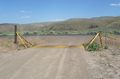
The cattle guard where Pole Creek Road meets the highway.
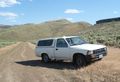
The truck didn't make it too far down the road.
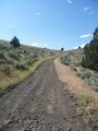
"Road" is actually putting it pretty strongly.
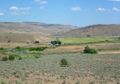
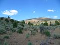
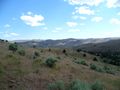
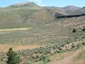
A nice view of the valley of the Malheur River.
The hashpoint is half a mile up there...
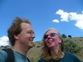
And we made it!
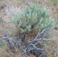
The sagebrush that lives at the hashpoint.
The view south.
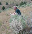
Mrs.5000 rests.
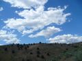
Pretty clouds.
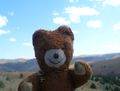
The Bear was there of course.
It was nice to see the truck again.


Achievements
Michael5000 and Mrs.5000 earned the Graticule Unlocked Achievement
|
Michael5000 and Mrs.5000 earned the Land geohash achievement
|
Michael5000 and Mrs.5000 earned the Multihash Achievement
|