Difference between revisions of "2011-07-18 45 -117"
imported>Michael5000 (→Location) |
m (per Renaming Proposal) |
||
| (9 intermediate revisions by 4 users not shown) | |||
| Line 1: | Line 1: | ||
| − | |||
| − | |||
| − | |||
| − | |||
| − | |||
| − | |||
| − | |||
| − | |||
| − | |||
| − | |||
{{meetup graticule | {{meetup graticule | ||
| lat=45 | | lat=45 | ||
| Line 15: | Line 5: | ||
}} | }} | ||
| − | + | [[File:2011-07-18 45 -117 looking south.JPG|left|400 px]] | |
| + | |||
__NOTOC__ | __NOTOC__ | ||
== Location == | == Location == | ||
| Line 22: | Line 13: | ||
== Participants == | == Participants == | ||
| − | |||
| − | + | *[[User:Michael5000|Michael5000]] | |
| − | + | *[[User:Mrs.5000|Mrs.5000]] | |
== Expedition == | == Expedition == | ||
| − | |||
| − | + | This was the first known attempt to hash the Enterprise graticule. [''cue Star Trek music''] | |
| − | + | ||
| + | On the fourth day of our geohash-assisted road trip, we woke in Ontario Oregon, to see two maybe-maybe-not hashpoints and a real creampuff. We decided to just go for the creampuff. After much discussion, we then went to it by a circuitous route that unfortunately had us driving less than a mile past the very possibly doable Payette, Idaho hashpoint having forgotten it was there. Oops. | ||
| + | |||
| + | Oh well. The Enterprise hashpoint sat on a rail grade just off a small, winding state highway. Between the railbed and the road, there was a ditch with a marshy creek running through it, but no worries -- a ranch access point less than a quarter mile south gave us a place to park and get access to the tracks. It was not a long walk to the hashpoint, and there was ample clearance by the railbeds. My GPS put the point right between the rails, so we took a few pictures but, for obvious reasons, did not spread out a celebratory picnic. | ||
| + | |||
| + | Expedition Success. | ||
== Photos == | == Photos == | ||
| − | |||
| − | |||
| − | |||
<gallery perrow="5"> | <gallery perrow="5"> | ||
| + | File:2011-07-18 45 -117 loking north.JPG|Looking north from the hashpoint. | ||
| + | File:2011-07-18 45 -117 looking south.JPG|Looking south from the hashpoint. | ||
| + | File:2011-07-18 45 -117 humans.JPG|Traditional human shot. | ||
| + | File:2011-07-18 45 -117 bear.JPG|Traditional bear shot. | ||
| + | File:2011-07-18 45 -117 siding.JPG|The Crooks siding, about a quarter mile south. | ||
</gallery> | </gallery> | ||
== Achievements == | == Achievements == | ||
{{#vardefine:ribbonwidth|800px}} | {{#vardefine:ribbonwidth|800px}} | ||
| − | |||
| + | {{Graticule unlocked | ||
| + | | latitude = 45 | ||
| + | | longitude = -117 | ||
| + | | date = 2011-07-18 | ||
| + | | name = [[User:Michael5000|Michael5000]] and [[User:Mrs.5000|Mrs.5000]] | ||
| + | | image = 2011-07-18 45 -117 looking south.JPG | ||
| + | }} | ||
| + | |||
| + | {{gratuitous ribbon | ||
| − | + | | icon = GHTR_rail.png | |
| − | + | | latitude = 45 | |
| − | [[ | + | | longitude = -117 |
| + | | date = 2011-07-18 | ||
| + | | achievement = Railhash Achievement | ||
| + | | description = visiting the hash situating on the railway. | ||
| + | | name = [[User:Michael5000|Michael5000]] and [[User:Mrs.5000|Mrs.5000]] | ||
| + | | image = 2011-07-18 45 -117 looking south.JPG | ||
| + | }} | ||
| − | |||
| − | |||
| − | |||
| − | |||
| − | |||
[[Category:Expeditions]] | [[Category:Expeditions]] | ||
| − | |||
[[Category:Expeditions with photos]] | [[Category:Expeditions with photos]] | ||
| − | |||
| − | |||
| − | |||
| − | |||
| − | |||
[[Category:Coordinates reached]] | [[Category:Coordinates reached]] | ||
| − | + | {{location|US|OR|UN}} | |
| − | |||
| − | |||
| − | |||
| − | |||
| − | |||
| − | |||
| − | |||
| − | |||
| − | |||
Latest revision as of 05:52, 20 March 2024
| Mon 18 Jul 2011 in 45,-117: 45.1594926, -117.8690863 geohashing.info google osm bing/os kml crox |

Location
Just north of Crooks siding on the Union Pacific Railroad, south of Union, Oregon.
Participants
Expedition
This was the first known attempt to hash the Enterprise graticule. [cue Star Trek music]
On the fourth day of our geohash-assisted road trip, we woke in Ontario Oregon, to see two maybe-maybe-not hashpoints and a real creampuff. We decided to just go for the creampuff. After much discussion, we then went to it by a circuitous route that unfortunately had us driving less than a mile past the very possibly doable Payette, Idaho hashpoint having forgotten it was there. Oops.
Oh well. The Enterprise hashpoint sat on a rail grade just off a small, winding state highway. Between the railbed and the road, there was a ditch with a marshy creek running through it, but no worries -- a ranch access point less than a quarter mile south gave us a place to park and get access to the tracks. It was not a long walk to the hashpoint, and there was ample clearance by the railbeds. My GPS put the point right between the rails, so we took a few pictures but, for obvious reasons, did not spread out a celebratory picnic.
Expedition Success.
Photos
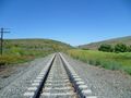
Looking north from the hashpoint.
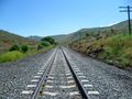
Looking south from the hashpoint.

Traditional human shot.
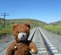
Traditional bear shot.
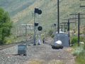
The Crooks siding, about a quarter mile south.


Achievements
Michael5000 and Mrs.5000 earned the Graticule Unlocked Achievement
|
Michael5000 and Mrs.5000 earned the Railhash Achievement
|