Difference between revisions of "2011-07-21 59 17"
From Geohashing
imported>Per Scheffer (Created page with "<!-- If you did not specify these parameters in the template, please substitute appropriate values for IMAGE, LAT, LON, and DATE (YYYY-MM-DD format) [[Image:{{{image|IMAGE}}}|t...") |
imported>FippeBot m (Location) |
||
| (11 intermediate revisions by 2 users not shown) | |||
| Line 1: | Line 1: | ||
| − | + | {| width="100%" border=0 cellpadding=0 cellspacing=0 style="border: 0; border-collapse: collapse; border-spacing: 0; margin: 0; padding: 0" | |
| − | [[Image: | + | | align="left" valign="top" style="padding: 0.5em 1em 0.5em 0" | [[Image:2011-07-21 59 17 2 The Field.jpg|467px]] |
| − | + | | align="right" valign="top" | {{meetup graticule | |
| − | |||
| − | |||
| − | |||
| − | |||
| − | |||
| − | {{meetup graticule | ||
| lat=59 | | lat=59 | ||
| lon=17 | | lon=17 | ||
| Line 15: | Line 9: | ||
| graticule_name=Uppsala | | graticule_name=Uppsala | ||
| graticule_link=Uppsala, Sweden | | graticule_link=Uppsala, Sweden | ||
| − | }} | + | }} |
| + | |||
| + | |} | ||
__NOTOC__ | __NOTOC__ | ||
== Location == | == Location == | ||
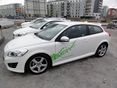
| − | In a field close to Ekerövägen, Ekerö, Sweden | + | In a wheat field close to Ekerövägen, Ekerö, Sweden |
== Participants == | == Participants == | ||
| − | * [[User:Per | + | * [[User:Per S|Per S]] |
* barngroda80 | * barngroda80 | ||
| Line 30: | Line 26: | ||
== Expedition == | == Expedition == | ||
| − | + | After visiting the [[Stockholm, Sweden]] hashpoint and stopping for lunch, we continued to this hashpoint. It was located in a wheat field close to the road and we parked on a small road right next to it. | |
| − | |||
| − | |||
| − | |||
== Photos == | == Photos == | ||
| − | < | + | <gallery widths=117px perrow="5"> |
| − | Image: | + | Image:2011-07-21 59 17 1 Todays Citation.jpg | Today's [[Citation Needed|citation]] |
| − | -- | + | Image:2011-07-21 59 17 2 The Field.jpg | The field |
| − | + | Image:2011-07-21 59 17 3 Coordinates Reached.jpg | Coordinates reached | |
| + | Image:2011-07-21 59 17 4 The Geohasher.jpg | The geohasher | ||
| + | Image:2011-07-21 59 17 5 Marker.jpg | Marker | ||
</gallery> | </gallery> | ||
== Achievements == | == Achievements == | ||
| − | {{#vardefine:ribbonwidth| | + | {{#vardefine:ribbonwidth|100%}} |
| − | |||
| − | [[ | + | {| |
| + | |||
| + | |{{Multihash | ||
| + | | latitude1 = 59 | ||
| + | | longitude1 = 18 | ||
| + | | latitude2 = 59 | ||
| + | | longitude2 = 17 | ||
| + | | date = 2011-07-21 | ||
| + | | name = [[User:Per S|Per S]] | ||
| + | | image = 2011-07-21 59 17 2 The Field.jpg | ||
| + | }} | ||
| + | |||
| + | |- | ||
| + | |||
| + | |{{Minesweeper geohash | ||
| + | | graticule = Stockholm, Sweden | ||
| + | | ranknumber = 1 | ||
| + | | w = true | ||
| + | | name = [[User:Per S|Per S]] | ||
| + | }} | ||
| + | |||
| + | |} | ||
| − | |||
[[Category:Expeditions]] | [[Category:Expeditions]] | ||
| − | |||
[[Category:Expeditions with photos]] | [[Category:Expeditions with photos]] | ||
| − | |||
| − | |||
| − | |||
| − | |||
| − | |||
[[Category:Coordinates reached]] | [[Category:Coordinates reached]] | ||
| − | + | {{location|SE|AB}} | |
| − | |||
| − | |||
| − | |||
| − | |||
| − | |||
| − | |||
| − | |||
| − | |||
| − | |||
Latest revision as of 00:12, 13 August 2019

|
| ||||||
Location
In a wheat field close to Ekerövägen, Ekerö, Sweden
Participants
- Per S
- barngroda80
Plans
To drive to this hashpoint after visiting the Stockholm, Sweden hashpoint and also to visit barngroda80's dad who lives nearby.
Expedition
After visiting the Stockholm, Sweden hashpoint and stopping for lunch, we continued to this hashpoint. It was located in a wheat field close to the road and we parked on a small road right next to it.
Photos
Today's citation
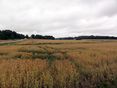
The field
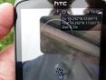
Coordinates reached

The geohasher
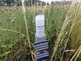
Marker


Achievements
| |||||||||||
|