Difference between revisions of "2011-07-28 66 25"
From Geohashing
imported>Isopekka (Created page with "thumb|left {{meetup graticule | lat=66 | lon=25 | date=2011-07-28 }} == Location == About 14 km to the NE from my home, in Nivankylä, near...") |
imported>Isopekka |
||
| Line 51: | Line 51: | ||
Image:Ghscreen.jpg| The Proof | Image:Ghscreen.jpg| The Proof | ||
Image:Gh2011-07-28 008.JPG| On the way back to the car. | Image:Gh2011-07-28 008.JPG| On the way back to the car. | ||
| − | Image:Gh2011-07-28 009.JPG| | + | Image:Gh2011-07-28 009.JPG| Wild raspberry. |
</gallery> | </gallery> | ||
Revision as of 15:26, 28 July 2011

| Thu 28 Jul 2011 in 66,25: 66.5918538, 25.5768172 geohashing.info google osm bing/os kml crox |
Contents
Location
About 14 km to the NE from my home, in Nivankylä, near the forest road
Participants
Expedition
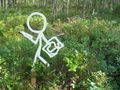
This was special hashing day: I have made a wooden geohash friend and today was his virgin expedition. The Hashpoint was a easy one, only 30 meters aside from the privat forest road. My hashfriend worked as a marker for the Hash. But I have a problem: What is the name of my new friend? How is he officially called? If You have a proposal for the name, please write it here. It would help me to give a name to him.
My proposal for the name is:__________
- By car total 30 km
- Walking total 2.0 km
- Expedition took 1 h
- Physical effort (1-5): 2
Photos
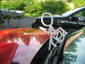
My new friend ready to go hashing.
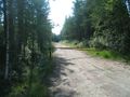
Oops! Privat road. I have to walk about 1 km.
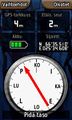
The Hash.
A closer view.
The Proof
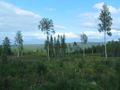
On the way back to the car.
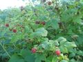
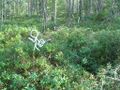
Wild raspberry.


Achievements
isopekka earned the Land geohash achievement
|
Geohashing Expeditions and Plans on This Day
Expeditions and Plans
| 2011-07-28 | ||
|---|---|---|
| Pakenham, Australia | Felix Dance | In a diary farm just outside Wonthaggi |
| København, Denmark | bjuhn | Todays hash is located on a quiet residential street in southern Amager. |
| Rovaniemi, Finland | isopekka | About 14 km to the NE from my home, in Nivankylä, near the forest road |