Difference between revisions of "2011-08-02 33 -84"
imported>NWoodruff (→Gallery) |
imported>FippeBot m (Location) |
||
| (One intermediate revision by one other user not shown) | |||
| Line 20: | Line 20: | ||
=== [[User:NWoodruff|NWoodruff]] === | === [[User:NWoodruff|NWoodruff]] === | ||
| + | |||
| + | I drove out to this location after work. I wasn't sure who's property that the hash point was on, so I knocked on the door of whom I though it would be. An older retired gentleman answered the door. I gave him the short version of Geohashing all the while pointing to the marker on the Google map. | ||
| + | |||
| + | He took the map from me and studied it a bit. He informed me that the marker point was not on his property and he didn't believe that the point was in the property of the subdivision that he lived on. He believed that the property was a part of a larger lot of land of someone that lived on a street over to the east. | ||
| + | |||
| + | Since the point was not more than 100 feet off of the older gentleman's, he said that I could walk though his back yard to access the point. I thanked the man and shook his hand. | ||
| + | |||
| + | I set off to the point and found it with 17 feet to go. With all the tall trees, the eTrex was having a problem locking on to a satellite signal. I settled on 17 feet a took a few pictures. | ||
| + | |||
| + | I then walked back to the man's house and thanked him for access. I then drove home to Norcross. | ||
== Gallery == | == Gallery == | ||
| Line 37: | Line 47: | ||
[[Category:Expeditions with photos]] | [[Category:Expeditions with photos]] | ||
[[Category:Coordinates reached]] | [[Category:Coordinates reached]] | ||
| + | {{location|US|GA|CB}} | ||
Latest revision as of 00:18, 13 August 2019
| Tue 2 Aug 2011 in Atlanta: 33.9617604, -84.6873238 geohashing.info google osm bing/os kml crox |
Graticule
About
In the back yard of a house in Kennesaw.
Expedition
NWoodruff
I drove out to this location after work. I wasn't sure who's property that the hash point was on, so I knocked on the door of whom I though it would be. An older retired gentleman answered the door. I gave him the short version of Geohashing all the while pointing to the marker on the Google map.
He took the map from me and studied it a bit. He informed me that the marker point was not on his property and he didn't believe that the point was in the property of the subdivision that he lived on. He believed that the property was a part of a larger lot of land of someone that lived on a street over to the east.
Since the point was not more than 100 feet off of the older gentleman's, he said that I could walk though his back yard to access the point. I thanked the man and shook his hand.
I set off to the point and found it with 17 feet to go. With all the tall trees, the eTrex was having a problem locking on to a satellite signal. I settled on 17 feet a took a few pictures.
I then walked back to the man's house and thanked him for access. I then drove home to Norcross.
Gallery
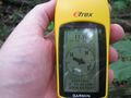
17.7 feet to go. Good enough.
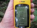
Time of the meetup.
Date of the meetup.
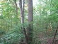
Looking North.
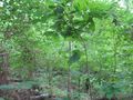
Looking South.

Me with a Stupid Grin™ with the camera looking East.


