Difference between revisions of "2011-08-07 -37 145"
imported>Felix Dance (Created Page!) |
imported>Felix Dance (Added images!) |
||
| Line 23: | Line 23: | ||
== Photos == | == Photos == | ||
| − | + | <gallery perrow="4"> | |
| − | <gallery perrow=" | + | File:2011 08 07 -37 145 Felix with Map.JPG|Felix with Map |
| − | + | File:-37 145 2011-08-07 Bikes at Hash.JPG|Bikes at the hash | |
| + | File:-37 145 2011-08-07 Felix and Sasha.JPG|Felix and Sasha | ||
| + | File:2011 08 07 -37 145 Vicki Crescent.JPG|Vicki Crescent | ||
</gallery> | </gallery> | ||
[[Category:Expeditions]] | [[Category:Expeditions]] | ||
[[Category:Coordinates reached]] | [[Category:Coordinates reached]] | ||
Revision as of 01:32, 12 August 2011
| Sun 7 Aug 2011 in -37,145: -37.7952912, 145.1473092 geohashing.info google osm bing/os kml crox |
Location
At the end of a cul-de-sac in Doncaster East.
Who went
- Felix Dance and Sasha
Expedition
Felix Dance
Sasha and I discovered the location for this geohash the day before, and since we were already planning to do a bike ride around that area, it was a no-brainer that we go for it. Riding from Sasha's place in Blackburn, we battled sporadic rain and yet more poor direction-finding from Sasha to at last arrive at the hash point, which was conveniently located right on the property boundary, under a wattle tree, at the end of a cute cul-de-sac a-la Neighbours.
Having forgotten my GPS we had to rely on the precision of a print-out of the area from Google Maps, but since we could resolve the very bush through which the hash passed, we reckon this ended up being more accurate than if we had used the GPS and therefore feel no compunction to not include it as a fail.
Donning our bikes and doffing our wet-weather gear we were off to the city along the Eastern Freeway bike path, interrupting our sojourn only to indulge in garish iced chocolate and cheap port at the Fairfield Boathouse. Not a bad afternoon's work.
Here is the CloudMade maps route we took.
Photos
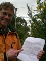
Felix with Map
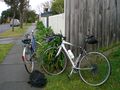
Bikes at the hash

Felix and Sasha
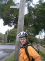
Vicki Crescent


