Difference between revisions of "2011-08-14 43 -123"
From Geohashing
imported>Michael5000 m (→Achievements) |
Michael5000 (talk | contribs) (→Location) |
||
| (5 intermediate revisions by 3 users not shown) | |||
| Line 1: | Line 1: | ||
| − | |||
| − | |||
| − | |||
| − | |||
| − | |||
| − | |||
| − | |||
| − | |||
| − | |||
{{meetup graticule | {{meetup graticule | ||
| lat=43 | | lat=43 | ||
| Line 18: | Line 9: | ||
== Location == | == Location == | ||
| − | + | '''Actual:''' Deep in the Coast Range, in Coos County. | |
| + | |||
| + | '''Perceived:''' Near Drain, Oregon. | ||
How embarrassing. It would appear that we were actually attempting to get to | How embarrassing. It would appear that we were actually attempting to get to | ||
| − | + | {{egl|2011-08-13|43|-123|text=yesterday's hashpoint}}. | |
We got within 220 feet of that. We didn't get anywhere near today's actual hashpoint. | We got within 220 feet of that. We didn't get anywhere near today's actual hashpoint. | ||
| Line 35: | Line 28: | ||
Except, it seems that the so-called "actual hashpoint" was | Except, it seems that the so-called "actual hashpoint" was | ||
| − | + | {{egl|2011-08-14|43|-123|text=yesterday's hashpoint}}, | |
so I'm an idiot. | so I'm an idiot. | ||
== Photos == | == Photos == | ||
| − | + | ||
| − | |||
| − | |||
<gallery perrow="5"> | <gallery perrow="5"> | ||
| + | File:2011-08 14 43 -123.JPG|The hashpoint was NOT in this dense stand of trees. We just thought it was. | ||
</gallery> | </gallery> | ||
== Achievements == | == Achievements == | ||
| − | |||
| − | |||
*I'm crediting this fiasco as our first attempt at Douglas County, since that's where we were. The real hashpoint was in Coos County, it appears. | *I'm crediting this fiasco as our first attempt at Douglas County, since that's where we were. The real hashpoint was in Coos County, it appears. | ||
| Line 56: | Line 46: | ||
[[Category:Coordinates not reached]] | [[Category:Coordinates not reached]] | ||
[[Category:Not reached - Technology]] | [[Category:Not reached - Technology]] | ||
| + | {{location|US|OR|CO}} | ||
Latest revision as of 02:23, 28 May 2022
| Sun 14 Aug 2011 in 43,-123: 43.3078350, -123.8894935 geohashing.info google osm bing/os kml crox |
Location
Actual: Deep in the Coast Range, in Coos County.
Perceived: Near Drain, Oregon.
How embarrassing. It would appear that we were actually attempting to get to yesterday's hashpoint. We got within 220 feet of that. We didn't get anywhere near today's actual hashpoint.
Participants
Expedition
On the way through the graticule, we pulled off of Highway 99/38 between I-5 and Drain, driving down a very small road to a gated logging road. We hiked up the logging road, but the "actual hashpoint" was deep in a very dense thicket.
Except, it seems that the so-called "actual hashpoint" was yesterday's hashpoint, so I'm an idiot.
Photos
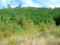
The hashpoint was NOT in this dense stand of trees. We just thought it was.

Achievements
- I'm crediting this fiasco as our first attempt at Douglas County, since that's where we were. The real hashpoint was in Coos County, it appears.