Difference between revisions of "2011-08-19 50 8"
imported>Mampfred ([live picture] Coordinates reached) |
imported>FippeBot m (Location) |
||
| (3 intermediate revisions by one other user not shown) | |||
| Line 1: | Line 1: | ||
| − | |||
| − | |||
| − | |||
| − | |||
| − | |||
| − | |||
| − | |||
| − | |||
| − | |||
| − | |||
{{meetup graticule | {{meetup graticule | ||
| lat=50 | | lat=50 | ||
| Line 15: | Line 5: | ||
}} | }} | ||
| − | |||
__NOTOC__ | __NOTOC__ | ||
== Location == | == Location == | ||
| − | + | Frankfurt Höchst, about 3km from the station with the same name next to the Autobahn. | |
== Participants == | == Participants == | ||
| − | + | *[[User:Mampfred|Mampfred]] | |
| + | *[[User:QuarterCacher|QuarterCacher]] | ||
== Plans == | == Plans == | ||
| − | + | Mampfred has to work for one of his clients in Frankfurt today and could pass by the hash on his way back as his S-Bahn actually stops in Höchst. So he phoned QuarterCacher and asked if he was close by and low and behold he's working in Frankfurt too so they might meet up in Höchst around 5pm and go together. | |
== Expedition == | == Expedition == | ||
| − | + | ===Mampfred=== | |
| + | Hmpf. Didn't quite turn out as planned. Took me about an hour in the morning to get to my clients office. Set up my laptop just to realize that my power adapter is broken so it was pointless staying at work as I couldn't do much without power. Very frustrating if you're payed by the hour ... | ||
| + | |||
| + | ... anyway, more time for hashing. Headed for Höchst and had a nice ~ 7 km walk starting with sunshine and ending with a massive rain downpour just as I got back to the station. I reached the coordinates alright. Although I have to admit that I approached the hash from the wood side and I'm not entirely sure if the actual coordinates were on the other side of a little fence seperating the wood from the Autobahn. But considering GPS in-accuracy and Hash Droid placing me 1,8 meters from it and a number of past hashes where I got "coordinates not reached" due to crops in the way and/or my social conscience I'll consider this one as reached. | ||
| + | |||
| + | On the way back I actually passed to geocaches, [http://coord.info/GC31PTV GC31PTV] and [http://coord.info/GC308NF GC308NF], found the first one, didn't find the second. | ||
| + | |||
| + | I had a chat with QuarterCacher and he might attempt to get there later. Or not. (Update: he went but didn't bother document it as usual ;) | ||
== Tracklog == | == Tracklog == | ||
| − | + | === Mampfred === | |
| + | See [http://www.everytrail.com/view_trip.php?trip_id=1252907 here]. | ||
== Photos == | == Photos == | ||
| − | + | === Mampfred === | |
| − | |||
| − | |||
<gallery perrow="5"> | <gallery perrow="5"> | ||
| − | + | Image:2011-08-19_50_8_no_motor_vehicles.jpg | Good that I didn't come by car. | |
| + | Image:2011-08-19_50_8_path.jpg | I'm walking ... | ||
| + | Image:2011-08-19_50_8_small_passage_away.jpg | ... could I get down there? ... | ||
| + | Image:2011-08-19_50_8_small_passage_sign.jpg | ... "XXXX enter", ok, entering as ordered ... | ||
| + | Image:2011-08-19_50_8_small_passage.jpg | ... through shortcuts ... | ||
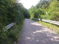
| + | Image:2011-08-19_50_8_bridge.jpg | ... across the bridge ... | ||
| + | Image:2011-08-19_50_8_autobahn.jpg | ... across the Autobahn ... | ||
| + | Image:2011-08-19_50_8_forrest_path.jpg | ... through the forest. | ||
| + | Image:2011-08-19_50_8_hash.jpg | Should be in there. | ||
Image:2011-08-19_50_8_10-45-06-707.jpg | Coordinates reached | Image:2011-08-19_50_8_10-45-06-707.jpg | Coordinates reached | ||
| + | Image:2011-08-19_50_8_grin.jpg | Slightly half-hearted (but reasonable stupid) grin. | ||
| + | Image:2011-08-19_50_8_autobahn_hash.jpg | A look back at the hash, should be there right next to the fence. | ||
| + | Image:2011-08-19_50_8_cache.jpg | [http://coord.info/GC31PTV GC31PTV] on the way back. | ||
| + | Image:2011-08-19_50_8_bridge_2.jpg | Another view from the bridge. Apparently there's another cache in that monster but I didn't have time for it. | ||
</gallery> | </gallery> | ||
== Achievements == | == Achievements == | ||
{{#vardefine:ribbonwidth|800px}} | {{#vardefine:ribbonwidth|800px}} | ||
| − | + | {{Land geohash | |
| + | | latitude = 50 | ||
| + | | longitude = 8 | ||
| + | | date = 2011-08-19 | ||
| + | | name = Mampfred and QuarterCacher | ||
| + | }} | ||
| + | {{public transport geohash | ||
| + | | latitude = 50 | ||
| + | | longitude = 8 | ||
| + | | date = 2011-08-19 | ||
| + | | name = Mampfred | ||
| + | }} | ||
| − | |||
| − | |||
| − | |||
| − | |||
| − | |||
| − | |||
| − | |||
| − | |||
| − | |||
| − | |||
| − | |||
[[Category:Expeditions]] | [[Category:Expeditions]] | ||
| − | |||
[[Category:Expeditions with photos]] | [[Category:Expeditions with photos]] | ||
| − | |||
| − | |||
| − | |||
| − | |||
| − | |||
[[Category:Coordinates reached]] | [[Category:Coordinates reached]] | ||
| − | + | {{location|DE|HE|F}} | |
| − | |||
| − | |||
| − | |||
| − | |||
| − | |||
| − | |||
| − | |||
| − | |||
| − | |||
Latest revision as of 00:30, 13 August 2019
| Fri 19 Aug 2011 in 50,8: 50.0815676, 8.5611858 geohashing.info google osm bing/os kml crox |
Location
Frankfurt Höchst, about 3km from the station with the same name next to the Autobahn.
Participants
Plans
Mampfred has to work for one of his clients in Frankfurt today and could pass by the hash on his way back as his S-Bahn actually stops in Höchst. So he phoned QuarterCacher and asked if he was close by and low and behold he's working in Frankfurt too so they might meet up in Höchst around 5pm and go together.
Expedition
Mampfred
Hmpf. Didn't quite turn out as planned. Took me about an hour in the morning to get to my clients office. Set up my laptop just to realize that my power adapter is broken so it was pointless staying at work as I couldn't do much without power. Very frustrating if you're payed by the hour ...
... anyway, more time for hashing. Headed for Höchst and had a nice ~ 7 km walk starting with sunshine and ending with a massive rain downpour just as I got back to the station. I reached the coordinates alright. Although I have to admit that I approached the hash from the wood side and I'm not entirely sure if the actual coordinates were on the other side of a little fence seperating the wood from the Autobahn. But considering GPS in-accuracy and Hash Droid placing me 1,8 meters from it and a number of past hashes where I got "coordinates not reached" due to crops in the way and/or my social conscience I'll consider this one as reached.
On the way back I actually passed to geocaches, GC31PTV and GC308NF, found the first one, didn't find the second.
I had a chat with QuarterCacher and he might attempt to get there later. Or not. (Update: he went but didn't bother document it as usual ;)
Tracklog
Mampfred
See here.
Photos
Mampfred
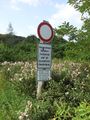
Good that I didn't come by car.
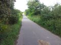
I'm walking ...
... could I get down there? ...
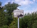
... "XXXX enter", ok, entering as ordered ...
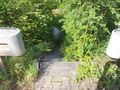
... through shortcuts ...
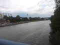
... across the bridge ...
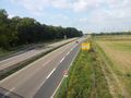
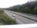
... across the Autobahn ...
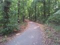
... through the forest.
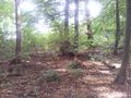
Should be in there.
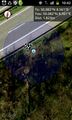
Coordinates reached

Slightly half-hearted (but reasonable stupid) grin.
A look back at the hash, should be there right next to the fence.
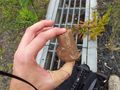
GC31PTV on the way back.
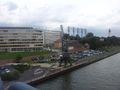
Another view from the bridge. Apparently there's another cache in that monster but I didn't have time for it.


Achievements
Mampfred and QuarterCacher earned the Land geohash achievement
|
Mampfred earned the Public transport geohash achievement
|