Difference between revisions of "2011-08-21 50 8"
imported>Mampfred ([live picture] Coordinates reached) |
imported>Mampfred |
||
| Line 1: | Line 1: | ||
| − | |||
| − | |||
| − | |||
| − | |||
| − | |||
| − | |||
| − | |||
| − | |||
| − | |||
| − | |||
{{meetup graticule | {{meetup graticule | ||
| lat=50 | | lat=50 | ||
| Line 15: | Line 5: | ||
}} | }} | ||
| − | |||
__NOTOC__ | __NOTOC__ | ||
== Location == | == Location == | ||
| − | + | In a field near Hofheim. | |
== Participants == | == Participants == | ||
| − | + | *[[User:Mampfred|Mampfred]] | |
| + | *[[User:QuarterCacher|QuarterCacher]] | ||
| + | *[[User:LadyBB|LadyBB]] +1 | ||
== Plans == | == Plans == | ||
| − | + | Go there after breakfast. Mampfred and QuarterCacher briefly thought about making it a walk geohash (~10km one way) but decided against it due to it being sunday and they're lazy and | |
| + | they both have other appointments later that day. | ||
== Expedition == | == Expedition == | ||
| − | + | LadyBB decided to join in as it might be her last hash before +1 becomes something else. It's been raining all morning so we decided to drive as close as possible which turned out to be about 50 meters from the hash. Walked on the field, took some photos and enjoyned the drizzle :) | |
| + | |||
| + | We actually consulted c:geo if there were any caches nearby but internet reception was so bad there (maybe the power lines above our heads) and the drizzle soon turned into a full blown thunderstorm so we headed back to QuarterCachers place to have a nice Cappucino, all is well that ends well. | ||
== Tracklog == | == Tracklog == | ||
| − | + | TODO | |
== Photos == | == Photos == | ||
| − | + | TODO | |
| − | |||
| − | |||
<gallery perrow="5"> | <gallery perrow="5"> | ||
| − | |||
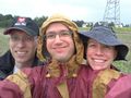
Image:2011-08-21_50_8_12-13-30-990.jpg | Coordinates reached | Image:2011-08-21_50_8_12-13-30-990.jpg | Coordinates reached | ||
</gallery> | </gallery> | ||
| Line 43: | Line 34: | ||
== Achievements == | == Achievements == | ||
{{#vardefine:ribbonwidth|800px}} | {{#vardefine:ribbonwidth|800px}} | ||
| − | + | * Land | |
| − | |||
| − | |||
| − | |||
| − | |||
| − | |||
| − | |||
| − | |||
| − | |||
| − | |||
| − | |||
| − | |||
[[Category:Expeditions]] | [[Category:Expeditions]] | ||
| − | |||
[[Category:Expeditions with photos]] | [[Category:Expeditions with photos]] | ||
| − | |||
| − | |||
| − | |||
| − | |||
| − | |||
[[Category:Coordinates reached]] | [[Category:Coordinates reached]] | ||
| − | |||
| − | |||
| − | |||
| − | |||
| − | |||
| − | |||
| − | |||
| − | |||
| − | |||
| − | |||
Revision as of 10:48, 21 August 2011
| Sun 21 Aug 2011 in 50,8: 50.0653852, 8.4279147 geohashing.info google osm bing/os kml crox |
Location
In a field near Hofheim.
Participants
Plans
Go there after breakfast. Mampfred and QuarterCacher briefly thought about making it a walk geohash (~10km one way) but decided against it due to it being sunday and they're lazy and they both have other appointments later that day.
Expedition
LadyBB decided to join in as it might be her last hash before +1 becomes something else. It's been raining all morning so we decided to drive as close as possible which turned out to be about 50 meters from the hash. Walked on the field, took some photos and enjoyned the drizzle :)
We actually consulted c:geo if there were any caches nearby but internet reception was so bad there (maybe the power lines above our heads) and the drizzle soon turned into a full blown thunderstorm so we headed back to QuarterCachers place to have a nice Cappucino, all is well that ends well.
Tracklog
TODO
Photos
TODO
Coordinates reached

Achievements
- Land