Difference between revisions of "2011-08-25 60 22"
From Geohashing
imported>Jiml m (Adjust result codes) |
imported>Eldin m (clean up template and check categories.) |
||
| Line 1: | Line 1: | ||
| − | |||
| − | |||
| − | |||
| − | |||
| − | |||
| − | |||
| − | |||
| − | |||
| − | |||
{{meetup graticule | {{meetup graticule | ||
| lat=60 | | lat=60 | ||
| Line 14: | Line 5: | ||
}} | }} | ||
| − | |||
__NOTOC__ | __NOTOC__ | ||
== Location == | == Location == | ||
| − | |||
South of Turku | South of Turku | ||
| Line 23: | Line 12: | ||
== Participants == | == Participants == | ||
| − | |||
* [[User:Team pson|team_pson]] | * [[User:Team pson|team_pson]] | ||
* [[User:Kosh63|kosh63]] | * [[User:Kosh63|kosh63]] | ||
| − | |||
| − | |||
| − | |||
== Expedition == | == Expedition == | ||
We had to go through a small forest (terrain: slightly rough, alot of 'mooseflies'!) before we managed to reach this green grass field. | We had to go through a small forest (terrain: slightly rough, alot of 'mooseflies'!) before we managed to reach this green grass field. | ||
Also deployed a Munzee nearby the hashpoint up on a hill after a tough climb. | Also deployed a Munzee nearby the hashpoint up on a hill after a tough climb. | ||
| − | |||
*At the geohash -- [[User:Team pson|team_pson]] [http://www.openstreetmap.org/?lat=60.30698747&lon=22.16958913&zoom=16&layers=B000FTF @60.3070,22.1696] 11:59, 25 August 2011 (EDT)/ 18:59(UTC+2) | *At the geohash -- [[User:Team pson|team_pson]] [http://www.openstreetmap.org/?lat=60.30698747&lon=22.16958913&zoom=16&layers=B000FTF @60.3070,22.1696] 11:59, 25 August 2011 (EDT)/ 18:59(UTC+2) | ||
| − | |||
| − | |||
| − | |||
== Photos == | == Photos == | ||
| − | |||
| − | |||
| − | |||
<gallery perrow="5"> | <gallery perrow="5"> | ||
| Line 52: | Line 30: | ||
== Achievements == | == Achievements == | ||
| − | + | * [[Land Geohash]] | |
| − | |||
| − | |||
| − | |||
| − | |||
| − | |||
[[Category:Expeditions]] | [[Category:Expeditions]] | ||
| − | |||
[[Category:Expeditions with photos]] | [[Category:Expeditions with photos]] | ||
[[Category:Coordinates reached]] | [[Category:Coordinates reached]] | ||
Revision as of 04:12, 11 April 2013
| Thu 25 Aug 2011 in 60,22: 60.3071388, 22.1696721 geohashing.info google osm bing/os kml crox |
Location
South of Turku
Participants
Expedition
We had to go through a small forest (terrain: slightly rough, alot of 'mooseflies'!) before we managed to reach this green grass field. Also deployed a Munzee nearby the hashpoint up on a hill after a tough climb.
- At the geohash -- team_pson @60.3070,22.1696 11:59, 25 August 2011 (EDT)/ 18:59(UTC+2)
Photos
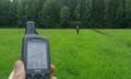
At the spot, kosh63 far back (first pic uploaded back at home w geohash droid with wrong coordinates, corrected)
