Difference between revisions of "2011-08-26 32 -110"
From Geohashing
imported>Bishop Wash (Created page with "{{meetup graticule | lat=32 | lon=-110 | date=2011-08-26 }} __NOTOC__ == Location == Bank at corner of Golf Links and Harrison in Tucson, Arizona == Participants == *[[User:Bi...") |
imported>Bishop Wash m (→Photos) |
||
| Line 18: | Line 18: | ||
<gallery perrow="3"> | <gallery perrow="3"> | ||
Image:2011-08-26_32_-110-GPS.jpg | GPS | Image:2011-08-26_32_-110-GPS.jpg | GPS | ||
| − | Image:2011-08-26_32_-110-Bank.jpg | View of drive-through | + | Image:2011-08-26_32_-110-Bank.jpg | View of drive-through; geohash just outside of the overhang |
</gallery> | </gallery> | ||
| + | |||
== Achievements == | == Achievements == | ||
{{land geohash | latitude = 32| longitude = -110 | date = 2011-08-26 | name = [[User:Bishop Wash|Bishop Wash]]}} | {{land geohash | latitude = 32| longitude = -110 | date = 2011-08-26 | name = [[User:Bishop Wash|Bishop Wash]]}} | ||
Revision as of 14:33, 27 August 2011
| Fri 26 Aug 2011 in 32,-110: 32.1911786, -110.7893606 geohashing.info google osm bing/os kml crox |
Location
Bank at corner of Golf Links and Harrison in Tucson, Arizona
Participants
Expedition
Bishop Wash: This geohash was easily accessible and I got it after work. The hash was just outside the drive through overhang. It was after the bank was closed, so I didn't have to worry about any traffic. Grabbed the hash and went to dinner.
Photos
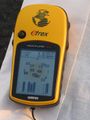
GPS
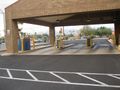
View of drive-through; geohash just outside of the overhang


Achievements
Bishop Wash earned the Land geohash achievement
|