Difference between revisions of "2011-08-26 49 10"
imported>Gefrierbrand |
imported>Gefrierbrand (Undo revision 288899 by Gefrierbrand (talk)) |
||
| Line 1: | Line 1: | ||
| − | |||
| − | |||
| − | |||
| − | |||
| − | |||
| − | |||
| − | |||
| − | |||
| − | |||
| − | |||
| − | |||
| − | |||
| − | |||
| − | |||
| − | |||
| − | |||
| − | |||
| − | |||
| − | |||
| − | |||
| − | |||
| − | |||
| − | |||
| − | |||
| − | |||
| − | |||
| − | |||
| − | |||
| − | |||
| − | |||
| − | |||
| − | |||
| − | |||
| − | |||
| − | |||
| − | |||
| − | |||
| − | |||
| − | |||
| − | |||
| − | |||
| − | |||
| − | |||
| − | |||
| − | |||
| − | |||
| − | |||
| − | |||
| − | |||
| − | |||
| − | |||
| − | |||
| − | |||
| − | |||
| − | |||
| − | |||
| − | |||
| − | |||
| − | |||
| − | |||
| − | |||
| − | |||
| − | |||
| − | |||
| − | |||
| − | |||
| − | |||
| − | |||
| − | |||
| − | |||
| − | |||
| − | |||
| − | |||
| − | |||
| − | |||
| − | |||
{{meetup graticule | {{meetup graticule | ||
| lat=49 | | lat=49 | ||
Revision as of 23:35, 26 August 2011
| Fri 26 Aug 2011 in 49,10: 49.9035423, 10.1313293 geohashing.info google osm bing/os kml crox |
Location
In the middle of a corn field near Dipbach.
Participants
Intro
Well this was my fist Geohash. I was trying to attempt one for months now but there was always something hindering me from actually starting in the first place. But this time everything was ideal. Not to far away so I could reach it using a bike, great weather conditions and plenty of time.
Plans
As I knew the general direction I had to go pretty well and had traveled some parts of the way before I decided to get as close as possible without using my mobile phone (and its great GeoHash Droid App). So there was no special preparation needed besides getting a bike as my own one is currently in Munich and therefore out of reach. I could use the bike from my sister after I inflated the tires and adjusted the (horribly uncomfortable) seat. A quickly staffed backpack including water, the map, money and my phone I was ready to go.
Expedition
I started shortly after 4pm local time at temperatures around 30°C heading towards Kürnach, the next neighboring Village to Estenfeld, where I live. I chose to use a slighty indirect route which involved climbing up a pretty annoying hill because I knew the view would reward me - See images 3 and 4. I had traveled the first view Kilometers of the route before and knew where to go which made things easy. Moreover I knew a quite prominent building (previously used as silo) in Prosselsheim, which was a checkpoint on my way, which can be seen from a relatively large distance if you know what to look for which was a great reference point. But before I got there, I was surprised to see a huge crowd of people attending a farming exhibition (with loud annoying music) basically in the middle of nowhere.
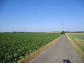
I got to Dipbach, the last small village before the Geohash quite easily as I had my map and really good bicycle lanes (including great direction signs). I knew from the Google Maps image where to go after that, but I was only able to mark this to a certain degree of precision in my map, so I had to go with my gut feeling tho where exactly it was. I knew it was of the road and as I guessed, I had to go inside a field full of corn, the only crop not harvested jet.
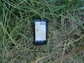
As there was absolutely no point to continue inside this field with just my map, I took out my phone and to my pleasure, I was only about 115 Meters away from the target. However, I could not just leave it at that. I had to go in there! Unfortunately, getting in there was rather unpleasant: I made my way through the corn, holding both arms and my phone like a shield in front of me to deflect the sharp edged leaves and got as close to the point as the precision of my phones GPS would allow. For a second, it displayed a deviation of less than 3 Meters, but refused to show that again as I tried to take the picture of it. But 5m is not bad either.
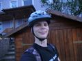
To that point, I had not realized that I still wore my helmet, which had to come off for the obligatory silly grin image. I then used the helmet to deflect the leaves on my way back out. Should have thought of that earlier.
Looking on my map, I realized I could go home using a different route without crossing my original path, as I had taken that small detour at the beginning of my track. Therefore I had to avoid the major roads and go more up- and downhill than I liked, but besides strong uprising winds and now dangerously near black clouds I made it back on the alternate route just before the rain started.
What a great and fun ride. Too bad nobody else showed up there.
Gallery
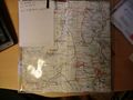
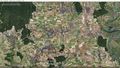
I started planning my tour using a bicycle map where I marked the locations as closely as I could.
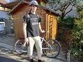
Start point in front of our house. Yes I wore that T-Shirt intentionally.
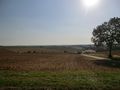
Beautiful view over Estenfeld and Würzburg in the background.
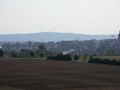
Again view over Estenfeld and Würzburg from the same location, but pretty zoomed in. You can make out Fortress Marienberg.
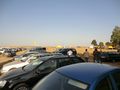
I came across an Exhibition where quite many people looked at tractors and combine harvesters.
Bavarian blue sky. The barely visible building with the arrow (old silo) was another station onwards to the Geohash...
... as seen here: The old silo up front.
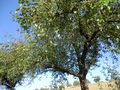
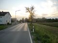
One single completely red apple in an otherwise fruit free tree.
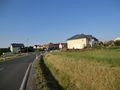
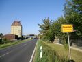
Entry to Dipbach, the village closest to the Geohash.
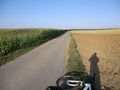
Almost there - The point is somewhere on the left in the corn field.
That's how close I got without using a GPS and navigating only with my Map.
So I had to go in there to reach the point.
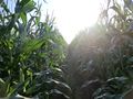
The first few steps were easy...
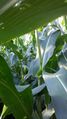
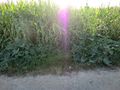
... but it became quite hard to move through the crops without damaging them.
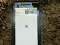
Target reached (to the best possible result as the GPS signal was quite weak.)
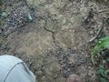
XKCD carved into the soil, little hard to read though

Silly grin at the hash location
On my way back some bigger clods showed up.
Home again. Just in time before the rain started.
My path.


Achievements
This user earned the Land geohash achievement
|
Gefrierbrand earned the Bicycle geohash achievement
|
Is it true that Gefrierbrand earned the Tron Achievement??
|