Difference between revisions of "2011-09-04 59 22"
imported>Jiml m (Lost h fix) |
imported>FippeBot m (Location) |
||
| (8 intermediate revisions by one other user not shown) | |||
| Line 19: | Line 19: | ||
__NOTOC__ | __NOTOC__ | ||
== Location == | == Location == | ||
| − | On | + | On a field next to the road Fårtvättsvägen in Bromarv, Raseborg. [http://bit.ly/nFQSyB Topo map]. [http://g.co/maps/dctwp Google Street View]. |
== Participants == | == Participants == | ||
| Line 28: | Line 28: | ||
== Expedition == | == Expedition == | ||
| − | Phone's navigator showed that the hashpoint was 45 km from home. Actually I checked it after the trip, as I didn't use the navigator to get there. First I searched a | + | Phone's navigator showed that the hashpoint was 45 km from home. Actually I checked it after the trip, as I didn't use the navigator to get there. First I searched [http://coord.info/GC32REQ a multicache] in Tenhola (Swedish: Tenala) village, then drove 25 km to the hash. The road was familiar to me, as I visit [http://bit.ly/pXX7TE Padva beach] once or twice each summer. |
| − | The | + | The hashpoint was on a ploughed field some 35 metres from a small road. Swedish name of the road is Fårtvättsvägen, Finnish Fårtvättintie. The Finnish name has been formed from the original Swedish name by changing genitive 's' to 'in' and vägen (= road) to tie (= road). That's necessary because we Finnish speakers wouldn't otherwise understand it's a road. And vice versa, where applicable. |
| − | The road leads to a place called... | + | The road leads to a place called... Fårtvätten. I think it means Sheep Washing. I had never thought there has been need to practice such thing. Google finds a picture about [http://www.flickr.com/photos/29289787@N08/4342942111/ sheep washing]. Probably there isn't a sheep washing pool in the end of the road, if there has ever been. |
| − | So I parked next to a barn, changed to rubber boots and loped to the hash on the clayey field. | + | So I parked next to a barn, changed to rubber boots and loped to the hash on the clayey field. I noticed from [http://bit.ly/nFQSyB the map] that there's a giant's kettle about 200 m west from Fårtvättsvägen. I should have walked there through the forest. Instead, I jumped to the car and hoped there is a car park on the side of the paved road, as the pothole was closer to it. But there wasn't room for the car, so I skipped the minor attraction. I searched two more nearby geocaches: [http://coord.info/GC3037V Bredvik Bunker] and [http://coord.info/GC1VKTZ Trollklyftan]. |
| − | |||
| − | |||
| − | |||
== Photos == | == Photos == | ||
| − | + | <gallery widths=300px heights=225px perrow="3"> | |
| − | + | Image:2011-09-04 59 22 crossing.jpg | Crossing of Vättlaxvägen and Fårtvättsvägen | |
| − | Image: | + | Image:2011-09-04 59 22 view to hash.jpg | View towards # |
| − | -- | + | Image:2011-09-04 59 22 north.jpg | North |
| − | + | Image:2011-09-04 59 22 west.jpg | West | |
| + | Image:2011-09-04 59 22 south-west.jpg | South-West | ||
| + | Image:2011-09-04 59 22 GPS.jpg | A bad picture of GPS. Forgot to change the coordinate format. | ||
| + | Image:2011-09-04 59 22 road.jpg | Fårtvättsvägen | ||
</gallery> | </gallery> | ||
| Line 52: | Line 52: | ||
* Land geohash | * Land geohash | ||
| − | |||
| − | |||
[[Category:Expeditions]] | [[Category:Expeditions]] | ||
| − | + | [[Category:Expeditions with photos]] | |
[[Category:Coordinates reached]] | [[Category:Coordinates reached]] | ||
| + | {{location|FI|18}} | ||
Latest revision as of 00:45, 13 August 2019
| Sun 4 Sep 2011 in Hanko, Finland: 59.9459927, 22.9576861 geohashing.info google osm bing/os kml crox |
Location
On a field next to the road Fårtvättsvägen in Bromarv, Raseborg. Topo map. Google Street View.
Participants
Plans
Visit some geocaches and the hashpoint.
Expedition
Phone's navigator showed that the hashpoint was 45 km from home. Actually I checked it after the trip, as I didn't use the navigator to get there. First I searched a multicache in Tenhola (Swedish: Tenala) village, then drove 25 km to the hash. The road was familiar to me, as I visit Padva beach once or twice each summer.
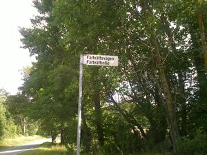
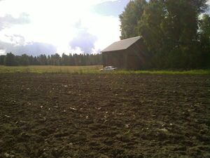
The hashpoint was on a ploughed field some 35 metres from a small road. Swedish name of the road is Fårtvättsvägen, Finnish Fårtvättintie. The Finnish name has been formed from the original Swedish name by changing genitive 's' to 'in' and vägen (= road) to tie (= road). That's necessary because we Finnish speakers wouldn't otherwise understand it's a road. And vice versa, where applicable.
The road leads to a place called... Fårtvätten. I think it means Sheep Washing. I had never thought there has been need to practice such thing. Google finds a picture about sheep washing. Probably there isn't a sheep washing pool in the end of the road, if there has ever been.
So I parked next to a barn, changed to rubber boots and loped to the hash on the clayey field. I noticed from the map that there's a giant's kettle about 200 m west from Fårtvättsvägen. I should have walked there through the forest. Instead, I jumped to the car and hoped there is a car park on the side of the paved road, as the pothole was closer to it. But there wasn't room for the car, so I skipped the minor attraction. I searched two more nearby geocaches: Bredvik Bunker and Trollklyftan.
Photos
Crossing of Vättlaxvägen and Fårtvättsvägen
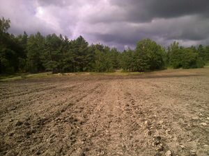
View towards #
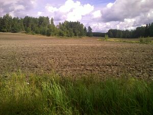
North
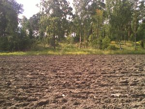
West
South-West
A bad picture of GPS. Forgot to change the coordinate format.
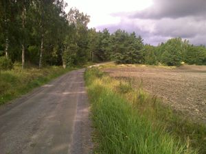
Fårtvättsvägen


Achievements
- Land geohash