Difference between revisions of "2011-09-09 50 8"
From Geohashing
imported>Mampfred ([live picture] Reached at 7:15am ... Ish) |
imported>FippeBot m (Location) |
||
| (3 intermediate revisions by one other user not shown) | |||
| Line 1: | Line 1: | ||
| − | |||
| − | |||
| − | |||
| − | |||
| − | |||
| − | |||
| − | |||
| − | |||
| − | |||
| − | |||
{{meetup graticule | {{meetup graticule | ||
| lat=50 | | lat=50 | ||
| Line 15: | Line 5: | ||
}} | }} | ||
| − | |||
__NOTOC__ | __NOTOC__ | ||
== Location == | == Location == | ||
| − | + | On a field near Eschborn. | |
== Participants == | == Participants == | ||
| − | + | *[[User:M|M]] | |
| + | *[[User:Mampfred|Mampfred]] | ||
| + | *[[User:QuarterCacher|QuarterCacher]] | ||
== Plans == | == Plans == | ||
| − | + | Go there before work! | |
== Expedition == | == Expedition == | ||
| − | + | Made it, M drove the rest of the bunch. It took a lot longer than expected due to morning traffic so we all got to work a bit late but hey ... | |
| + | Two in a row, can't wait to get the coordinates for the weekend :) | ||
| − | |||
== Tracklog == | == Tracklog == | ||
| − | + | See [http://www.everytrail.com/view_trip.php?trip_id=1279338 here]. | |
== Photos == | == Photos == | ||
| − | |||
| − | |||
| − | |||
<gallery perrow="5"> | <gallery perrow="5"> | ||
| − | + | Image:2011-09-09_50_8_the_hash.jpg | Look at the hash. | |
| − | Image:2011-09-09_50_8_08-25-05-595.jpg | | + | Image:2011-09-09_50_8_08-25-05-595.jpg | Hashers back at the car. |
</gallery> | </gallery> | ||
== Achievements == | == Achievements == | ||
{{#vardefine:ribbonwidth|800px}} | {{#vardefine:ribbonwidth|800px}} | ||
| − | + | {{Land geohash | |
| + | | latitude = 50 | ||
| + | | longitude = 8 | ||
| + | | date = 2011-09-09 | ||
| + | | name = Mampfred, QuarterCacher and M | ||
| + | }} | ||
| + | {{Consecutive_geohash | ||
| + | | latitude = 50 | ||
| + | | longitude = 8 | ||
| + | | count = 2 | ||
| + | | date = 2011-09-08 | ||
| + | | name = [[User:QuarterCacher|QuarterCacher]], [[User:Mampfred|Mampfred]] | ||
| + | }} | ||
| − | |||
| − | |||
| − | |||
| − | |||
| − | |||
| − | |||
| − | |||
| − | |||
| − | |||
| − | |||
| − | |||
[[Category:Expeditions]] | [[Category:Expeditions]] | ||
| − | |||
[[Category:Expeditions with photos]] | [[Category:Expeditions with photos]] | ||
| − | |||
| − | |||
| − | |||
| − | |||
| − | |||
[[Category:Coordinates reached]] | [[Category:Coordinates reached]] | ||
| − | + | {{location|DE|HE|MTK}} | |
| − | |||
| − | |||
| − | |||
| − | |||
| − | |||
| − | |||
| − | |||
| − | |||
| − | |||
Latest revision as of 00:46, 13 August 2019
| Fri 9 Sep 2011 in 50,8: 50.1455768, 8.5876481 geohashing.info google osm bing/os kml crox |
Location
On a field near Eschborn.
Participants
Plans
Go there before work!
Expedition
Made it, M drove the rest of the bunch. It took a lot longer than expected due to morning traffic so we all got to work a bit late but hey ...
Two in a row, can't wait to get the coordinates for the weekend :)
Tracklog
See here.
Photos
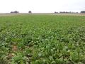
Look at the hash.
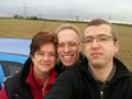
Hashers back at the car.


Achievements
Mampfred, QuarterCacher and M earned the Land geohash achievement
|
QuarterCacher, Mampfred earned the Consecutive geohash achievement
|