Difference between revisions of "2011-09-17 45 -121"
(→Expedition) |
imported>FippeBot m (Location) |
||
| (2 intermediate revisions by one other user not shown) | |||
| Line 27: | Line 27: | ||
== Expedition == | == Expedition == | ||
Fail. | Fail. | ||
| − | + | The drive up to where I hit the trail was 4 mi in and 1/4 mi up, the trail part was 4/5 mi each way with 350 ft gain. And then there was the wandering around the forest part. Once I went into the woods I was not happy with the map vs what I saw, nor was I happy with the GPS. And it started raining. | |
| − | + | I was expecting a mostly horizontal walk, looking at the topo lines, but sometimes reality doesn't look like the map. The GPS was pointing me in a direction that my dead reckoning didn't like. And it started raining. | |
| − | + | So home I came. No geohash, but a nice walk. Did I mention that it started raining. | |
== Tracklog == | == Tracklog == | ||
| Line 36: | Line 36: | ||
== Photos == | == Photos == | ||
| − | <gallery perrow=" | + | <gallery perrow="6"> |
| − | + | Image:2011-09-17 45 -121 way up high.jpg|This is from just about where I parked the car. | |
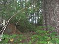
| + | Image:2011-09-17 45 -121 Road no more.jpg|Google showed this as a road. I knew better. | ||
| + | Image:2011-09-17 45 -121 profile.JPG|A profile diagram of my walk. | ||
| + | Image:2011-09-17 45 -121 ridge walk.jpg|I walked further up the trail than the 2320 contour line looking for a way in. Off the trail I went up to a ridge and walked it. But everything to my right dropped off. A lot. | ||
| + | Image:2011-09-17 45 -121 not a traverse.jpg|Looking North things dropped off very steeply. How come photos never capture this ? | ||
| + | Image:2011-09-17 45 -121 alot of this.jpg|It is so hard to walk a line in this terrain. | ||
</gallery> | </gallery> | ||
| Line 48: | Line 53: | ||
[[Category:Coordinates not reached]] | [[Category:Coordinates not reached]] | ||
[[Category:Not reached - Mother Nature]] | [[Category:Not reached - Mother Nature]] | ||
| + | {{location|US|WA|SM}} | ||
Latest revision as of 00:53, 13 August 2019
| Sat 17 Sep 2011 in 45,-121: 45.7586070, -121.8922134 geohashing.info google osm bing/os kml crox |
Location
North of Stevenson, WA
Participants
Plans
Kydlt I wonder if this will ever happen again: No matter where you come from you go right past my place on the way to this hash. (Correction, you could go through Carson.) So I guess I will run on up the hill. I wasn't going to go out today, but it's only 6 miles and when will it ever be this close again ?
Expedition
Fail. The drive up to where I hit the trail was 4 mi in and 1/4 mi up, the trail part was 4/5 mi each way with 350 ft gain. And then there was the wandering around the forest part. Once I went into the woods I was not happy with the map vs what I saw, nor was I happy with the GPS. And it started raining. I was expecting a mostly horizontal walk, looking at the topo lines, but sometimes reality doesn't look like the map. The GPS was pointing me in a direction that my dead reckoning didn't like. And it started raining. So home I came. No geohash, but a nice walk. Did I mention that it started raining.
Tracklog
Photos
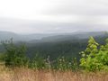
This is from just about where I parked the car.
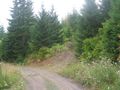
Google showed this as a road. I knew better.
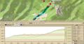
A profile diagram of my walk.
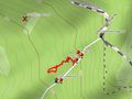
I walked further up the trail than the 2320 contour line looking for a way in. Off the trail I went up to a ridge and walked it. But everything to my right dropped off. A lot.

Looking North things dropped off very steeply. How come photos never capture this ?
It is so hard to walk a line in this terrain.


