Difference between revisions of "2011-09-22 50 8"
imported>Mampfred (Created page with "{{subst:Expedition |lat = 50 |lon = 8 |date = 2011-09-22 }}") |
imported>FippeBot m (Location) |
||
| (3 intermediate revisions by one other user not shown) | |||
| Line 1: | Line 1: | ||
| − | |||
| − | |||
| − | |||
| − | |||
| − | |||
| − | |||
| − | |||
| − | |||
| − | |||
| − | |||
{{meetup graticule | {{meetup graticule | ||
| lat=50 | | lat=50 | ||
| Line 15: | Line 5: | ||
}} | }} | ||
| − | |||
__NOTOC__ | __NOTOC__ | ||
== Location == | == Location == | ||
| − | + | Somewhere in Schlossborn. Quite probably private property looking at Google Maps. | |
== Participants == | == Participants == | ||
| − | + | *[[User:Mampfred|Mampfred]] | |
== Plans == | == Plans == | ||
| − | + | Have a quick look after work. Maybe it is accessible after all ... | |
== Expedition == | == Expedition == | ||
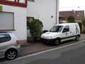
| − | + | Despite the not so good chances accordig to Google Maps I set off after work. It only took me 10 minutes to drive there and I arrived in a very narrow road only 30 meters from the hash. I got out and approached the house at the corner as unsuspicious as possible, it turned out to be a shop caled the Schatzinsel (treasure island) that was closed already. To get to the hash, I had to step right up to the house and squeeze betwene the wall and a car parking in front of it, but luckily the GPS came down to 1 meter so it was just about outside of the house, nice one :) | |
== Tracklog == | == Tracklog == | ||
| − | + | See [http://www.everytrail.com/view_trip.php?trip_id=1298703 here]. | |
== Photos == | == Photos == | ||
| − | |||
| − | |||
| − | |||
<gallery perrow="5"> | <gallery perrow="5"> | ||
| + | Image:2011-09-22_50_8_schatzinsel.jpg | Seems to be behind a shop called Schatzinsel | ||
| + | Image:2011-09-22_50_8_coordinates.jpg | Coordinates ... | ||
| + | Image:2011-09-22_50_8_reached.jpg | ... reached. | ||
| + | Image:2011-09-22_50_8_hash_1.jpg | Looking at the hash angle 1 | ||
| + | Image:2011-09-22_50_8_hash_2.jpg | Looking at the hash angle 2 | ||
| + | Image:2011-09-22_50_8_mampf.jpg | Mampf in front of hash | ||
</gallery> | </gallery> | ||
== Achievements == | == Achievements == | ||
{{#vardefine:ribbonwidth|800px}} | {{#vardefine:ribbonwidth|800px}} | ||
| − | + | {{Land geohash | |
| + | | latitude = 50 | ||
| + | | longitude = 8 | ||
| + | | date = 2011-09-22 | ||
| + | | name = Mampfred | ||
| + | }} | ||
| − | |||
| − | |||
| − | |||
| − | |||
| − | |||
| − | |||
| − | |||
| − | |||
| − | |||
| − | |||
| − | |||
[[Category:Expeditions]] | [[Category:Expeditions]] | ||
| − | |||
[[Category:Expeditions with photos]] | [[Category:Expeditions with photos]] | ||
| − | |||
| − | |||
| − | |||
| − | |||
| − | |||
[[Category:Coordinates reached]] | [[Category:Coordinates reached]] | ||
| − | + | {{location|DE|HE|HG}} | |
| − | |||
| − | |||
| − | |||
| − | |||
| − | |||
| − | |||
| − | |||
| − | |||
| − | |||
Latest revision as of 00:58, 13 August 2019
| Thu 22 Sep 2011 in 50,8: 50.2002026, 8.3840388 geohashing.info google osm bing/os kml crox |
Location
Somewhere in Schlossborn. Quite probably private property looking at Google Maps.
Participants
Plans
Have a quick look after work. Maybe it is accessible after all ...
Expedition
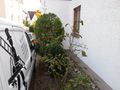
Despite the not so good chances accordig to Google Maps I set off after work. It only took me 10 minutes to drive there and I arrived in a very narrow road only 30 meters from the hash. I got out and approached the house at the corner as unsuspicious as possible, it turned out to be a shop caled the Schatzinsel (treasure island) that was closed already. To get to the hash, I had to step right up to the house and squeeze betwene the wall and a car parking in front of it, but luckily the GPS came down to 1 meter so it was just about outside of the house, nice one :)
Tracklog
See here.
Photos
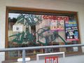
Seems to be behind a shop called Schatzinsel
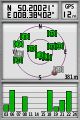
Coordinates ...
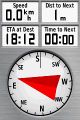
... reached.
Looking at the hash angle 1
Looking at the hash angle 2
- Error creating thumbnail: Unable to save thumbnail to destination
Mampf in front of hash


Achievements
Mampfred earned the Land geohash achievement
|