Difference between revisions of "2011-09-27 47 -122"
imported>Thomcat (Created page with "{{subst:Expedition |lat = 47 |lon = -122 |date = 2011-09-27 }}") |
imported>FippeBot m (Location) |
||
| (4 intermediate revisions by one other user not shown) | |||
| Line 1: | Line 1: | ||
| − | |||
| − | |||
| − | |||
| − | |||
| − | |||
| − | |||
| − | |||
| − | |||
| − | |||
| − | |||
{{meetup graticule | {{meetup graticule | ||
| lat=47 | | lat=47 | ||
| Line 15: | Line 5: | ||
}} | }} | ||
| − | |||
__NOTOC__ | __NOTOC__ | ||
== Location == | == Location == | ||
| − | + | On the track at [http://www.nsd.org/education/school/school.php?sectionid=30 Skyview Jr High] in somewhat rainy Bothell, Washington. | |
== Participants == | == Participants == | ||
| − | + | [[user:Thomcat|Thomcat]] | |
== Plans == | == Plans == | ||
| − | + | Today's location is less than 500m from [[User:Thomcat|Thomcat's]] office, so he plans to walk there. | |
== Expedition == | == Expedition == | ||
| − | + | The morning's rain let up and the sun came out. After round after round of oppressive meetings, I needed to get a breath of fresh air. | |
| + | |||
| + | A well kept trail leads up from the parking lot and ends up in the housing development south of the Geohash. Per the google satellite view, I should be able to cut through to the track. Nay, it was not to be. 68 meters from the geohash and 3 fences stood in my way. | ||
| + | |||
| + | I then trekked around to the east - the school's streetfront. Just as I reached the campus, the bell rang to let the kids go. A quick step along the track brought me to the hash point, where I took a few photos. A quick walk back got me to the office in time for an afternoon meeting. | ||
| − | + | Plus one successful geohash! | |
| − | |||
== Photos == | == Photos == | ||
| Line 37: | Line 29: | ||
--> | --> | ||
<gallery perrow="5"> | <gallery perrow="5"> | ||
| + | Image:2009-11-27_47_-122_ParkingSpot.jpg | Where I parked that morning | ||
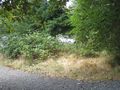
| + | Image:2009-11-27_47_-122_NoAccess.jpg | No Shortcuts apparently | ||
| + | Image:2009-11-27_47_-122_Pasture.jpg | We are in a Rural area | ||
| + | Image:2009-11-27_47_-122_SchoolZone.jpg | Getting close to the School | ||
| + | Image:2009-11-27_47_-122_TrackView.jpg | Just off the road, I can see the point | ||
| + | Image:2009-11-27_47_-122_Trackside.jpg | Geohash success! | ||
| + | Image:2009-11-27_47_-122_FieldView.jpg | Looking uphill to see the school and field | ||
| + | Image:2009-11-27_47_-122_SignNoted.jpg | I pinned the sign into the fence - no visitors | ||
| + | Image:2009-11-27_47_-122_Grin.jpg | A good day to walk and hash! | ||
| + | Image:2009-11-27_47_-122_TrailBack.jpg | From the trail my car appears | ||
</gallery> | </gallery> | ||
| − | |||
| − | |||
| − | |||
| − | |||
| − | |||
| − | |||
| − | |||
| − | |||
| − | |||
| − | |||
| − | |||
| − | |||
| − | |||
| − | |||
| − | |||
[[Category:Expeditions]] | [[Category:Expeditions]] | ||
| − | |||
[[Category:Expeditions with photos]] | [[Category:Expeditions with photos]] | ||
| − | |||
| − | |||
| − | |||
| − | |||
| − | |||
[[Category:Coordinates reached]] | [[Category:Coordinates reached]] | ||
| − | + | {{location|US|WA|SN}} | |
| − | |||
| − | |||
| − | |||
| − | |||
| − | |||
| − | |||
| − | |||
| − | |||
| − | |||
Latest revision as of 01:02, 13 August 2019
| Tue 27 Sep 2011 in 47,-122: 47.8022219, -122.1888926 geohashing.info google osm bing/os kml crox |
Location
On the track at Skyview Jr High in somewhat rainy Bothell, Washington.
Participants
Plans
Today's location is less than 500m from Thomcat's office, so he plans to walk there.
Expedition
The morning's rain let up and the sun came out. After round after round of oppressive meetings, I needed to get a breath of fresh air.
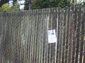
A well kept trail leads up from the parking lot and ends up in the housing development south of the Geohash. Per the google satellite view, I should be able to cut through to the track. Nay, it was not to be. 68 meters from the geohash and 3 fences stood in my way.
I then trekked around to the east - the school's streetfront. Just as I reached the campus, the bell rang to let the kids go. A quick step along the track brought me to the hash point, where I took a few photos. A quick walk back got me to the office in time for an afternoon meeting.
Plus one successful geohash!
Photos
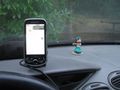
Where I parked that morning
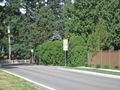
No Shortcuts apparently
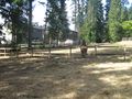
We are in a Rural area
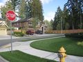
Getting close to the School
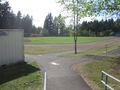
Just off the road, I can see the point
Geohash success!
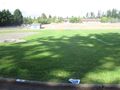
Looking uphill to see the school and field
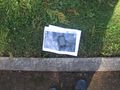
I pinned the sign into the fence - no visitors

A good day to walk and hash!
From the trail my car appears


