Difference between revisions of "2011-10-06 50 8"
From Geohashing
imported>Mampfred ([live picture] Coords reached) |
imported>FippeBot m (Location) |
||
| (3 intermediate revisions by one other user not shown) | |||
| Line 1: | Line 1: | ||
| − | + | {{advert|image=2011-10-06_50_8_marker.jpg}} | |
| − | |||
| − | |||
| − | |||
| − | |||
| − | |||
| − | |||
| − | |||
| − | |||
| − | |||
{{meetup graticule | {{meetup graticule | ||
| lat=50 | | lat=50 | ||
| Line 15: | Line 6: | ||
}} | }} | ||
| − | |||
__NOTOC__ | __NOTOC__ | ||
== Location == | == Location == | ||
| − | + | In a little clearing right next to a foot path in the woods surrounding the [http://de.wikipedia.org/wiki/Jagdschloss_Platte Jagdschloss Platte] (sorry, german only). | |
== Participants == | == Participants == | ||
| − | + | *[[User:Mampfred|Mampfred]] | |
| + | *[[User:QuarterCacher|QuarterCacher]] | ||
== Plans == | == Plans == | ||
| − | + | Mampfred is coming home late from a business trip. Meetup planned for ~8pm, about a 30 minute drive and a bit of walking. | |
== Expedition == | == Expedition == | ||
| − | + | Straight forward, we met up around 8pm and headed out. Our navigation system led us through half of Wiesbaden but we eventually got there and could drive even further than anticipated. The rest was an uneventful 800 meter walk in the dark. We left a marker, took some badly lit photos and headed back. | |
== Tracklog == | == Tracklog == | ||
| − | + | See [http://www.everytrail.com/view_trip.php?trip_id=1320211 here]. | |
== Photos == | == Photos == | ||
| − | |||
| − | |||
| − | |||
<gallery perrow="5"> | <gallery perrow="5"> | ||
| − | + | Image:2011-10-06_50_8_coordinates.jpg | Coordinates ... | |
| − | Image:2011-10-06_50_8_20-51-26-299.jpg | | + | Image:2011-10-06_50_8_reached.jpg | ... reached. |
| + | Image:2011-10-06_50_8_map.jpg | Map view. | ||
| + | Image:2011-10-06_50_8_marker.jpg | Marker we left behind on a tree. | ||
| + | Image:2011-10-06_50_8_20-51-26-299.jpg | Stupid lighting. | ||
</gallery> | </gallery> | ||
== Achievements == | == Achievements == | ||
{{#vardefine:ribbonwidth|800px}} | {{#vardefine:ribbonwidth|800px}} | ||
| − | + | {{Land geohash | |
| + | | latitude = 50 | ||
| + | | longitude = 8 | ||
| + | | date = 2011-10-06 | ||
| + | | name = Mampfred and QuarterCacher | ||
| + | }} | ||
| − | |||
| − | |||
| − | |||
| − | |||
| − | |||
| − | |||
| − | |||
| − | |||
| − | |||
| − | |||
| − | |||
[[Category:Expeditions]] | [[Category:Expeditions]] | ||
| − | |||
[[Category:Expeditions with photos]] | [[Category:Expeditions with photos]] | ||
| − | |||
| − | |||
| − | |||
| − | |||
| − | |||
[[Category:Coordinates reached]] | [[Category:Coordinates reached]] | ||
| − | + | {{location|DE|HE|SWA}} | |
| − | |||
| − | |||
| − | |||
| − | |||
| − | |||
| − | |||
| − | |||
| − | |||
| − | |||
Latest revision as of 01:08, 13 August 2019
| Have you seen our geohashing marker? We'd love to hear from you! Click here to say "hi" and tell us what you've seen!
Curious about what geohashing is? Read more! |  |
| Thu 6 Oct 2011 in 50,8: 50.1432504, 8.2302286 geohashing.info google osm bing/os kml crox |
Location
In a little clearing right next to a foot path in the woods surrounding the Jagdschloss Platte (sorry, german only).
Participants
Plans
Mampfred is coming home late from a business trip. Meetup planned for ~8pm, about a 30 minute drive and a bit of walking.
Expedition
Straight forward, we met up around 8pm and headed out. Our navigation system led us through half of Wiesbaden but we eventually got there and could drive even further than anticipated. The rest was an uneventful 800 meter walk in the dark. We left a marker, took some badly lit photos and headed back.
Tracklog
See here.
Photos
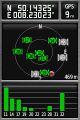
Coordinates ...
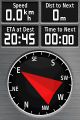
... reached.
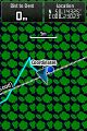
Map view.
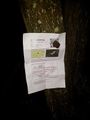
Marker we left behind on a tree.
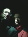
Stupid lighting.


Achievements
Mampfred and QuarterCacher earned the Land geohash achievement
|