Difference between revisions of "2011-10-09 41 -72"
m |
|||
| (2 intermediate revisions by 2 users not shown) | |||
| Line 14: | Line 14: | ||
}} | }} | ||
| − | + | ||
__NOTOC__ | __NOTOC__ | ||
== Location == | == Location == | ||
| Line 20: | Line 20: | ||
== Participants == | == Participants == | ||
| − | Rita | + | |
| + | * Rita - this was Rita's very first geohashing adventure. | ||
| + | * [[User:Asmiller-ke6seh|Seth]] | ||
== Plans == | == Plans == | ||
| − | To park the car on Emanuel Church Road and walk east into the woods using a smart phone's GPS, compass and map to guide us to | + | To park the car on Emanuel Church Road and walk east into the woods using a smart phone's GPS, compass and map to guide us to the geohash point. |
== Expedition == | == Expedition == | ||
| Line 33: | Line 35: | ||
== Photos == | == Photos == | ||
| − | |||
| − | |||
| − | |||
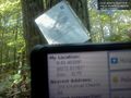
<gallery perrow="5"> | <gallery perrow="5"> | ||
| − | + | Image:2011-10-09_41_-72_18-33-29-224.jpg | The GPS | |
| − | Image:2011-10-09_41_-72_18-33-29-224.jpg | | ||
</gallery> | </gallery> | ||
== Achievements == | == Achievements == | ||
{{#vardefine:ribbonwidth|800px}} | {{#vardefine:ribbonwidth|800px}} | ||
| − | |||
| + | * Land Geohash | ||
| − | |||
| − | |||
| − | |||
| − | |||
| − | |||
| − | |||
| − | |||
| − | |||
[[Category:Expeditions]] | [[Category:Expeditions]] | ||
| − | + | ||
[[Category:Expeditions with photos]] | [[Category:Expeditions with photos]] | ||
| − | |||
| − | |||
| − | |||
| − | |||
| − | |||
[[Category:Coordinates reached]] | [[Category:Coordinates reached]] | ||
| − | + | {{location|US|CT|MI}} | |
| − | |||
| − | |||
| − | |||
| − | |||
| − | |||
| − | |||
| − | |||
| − | |||
| − | |||
Latest revision as of 18:43, 18 March 2022
| Sun 9 Oct 2011 in 41,-72: 41.4032732, -72.6177873 geohashing.info google osm bing/os kml crox |
Location
East of Emanuel Church Road, in the woods behind a private home at the end of a driveway less then a tenth of a mile into the woods where, at the end of the dirt road there are three dead cars. About 10 feet east of a 1980ish green car is a tree with our geohashing poster for today
Participants
- Rita - this was Rita's very first geohashing adventure.
- Seth
Plans
To park the car on Emanuel Church Road and walk east into the woods using a smart phone's GPS, compass and map to guide us to the geohash point.
Expedition
We traveled from home by car to Killington, Emanuel Church Road where we parked and crossed the road, entering into the woods. There where no trails, so we bushwacked as we followed the GPS, correcting direction as we advanced. We came upon a boggy stream which appeared to be too wide to cross without wading into deep mud. Walking a few feet southwards Rita decided that she was up to taking a reasonable risk, followed Seth across the narrowest place, crossing a rotting and mossy log, to a moss covered rock, and onto the other side. We then clambered up to a ridgeline overlooking a valley which descends steeply into a ravine with a small river, or large stream.
Paralleling the stream, traveling northward, we came upon the geohash point. We spotted a long abandoned green automobile. After posting the geohashing poster ("the Internet was here!") we proceeded along the old dirt road, only to discover that it entered the backyard of a private home. We begged the indulgence of one of the property owners and walked the rest of the way out, along their driveway and back up onto Emanuel Church Road, turning left and walking a little more than a tenth of a mile back to the car.
We stopped at Dairy Queen in Kensington on our way back home and had much deserved ice cream sundaes.
Photos
The GPS

Achievements
- Land Geohash