Difference between revisions of "2011-10-16 50 8"
imported>Rincewind (→Photos) |
imported>Mampfred (we were here too ...) |
||
| Line 11: | Line 11: | ||
== Participants == | == Participants == | ||
*[[User:Rincewind|Rincewind]] and Salta | *[[User:Rincewind|Rincewind]] and Salta | ||
| + | *[[User:Mampfred|Mampfred]] | ||
| + | *[[User:LadyBB|LadyBB]] | ||
| + | *[[User:EmmJay|EmmJay]] | ||
== Plans == | == Plans == | ||
| + | === Rincewind and Salta === | ||
Drive to the end of the village, walk a couple of hundred meters. | Drive to the end of the village, walk a couple of hundred meters. | ||
| + | |||
| + | === Mampfred, LadyBB and EmmJay === | ||
| + | We're going to visit dad/granddad and the hash is conveniantly only 10km away from his place. Will take place in the afternoon though. | ||
== Expedition == | == Expedition == | ||
| + | === Rincewind and Salta === | ||
We didn't get a proper satellite fix somehow and so went to the hilltop first. | We didn't get a proper satellite fix somehow and so went to the hilltop first. | ||
When we realized it was just 1100m anyway, we took the parking lot for leisure walkers there and started our search. The weather was really beautiful, so walking seemed rather a treat than a duty, anyway. | When we realized it was just 1100m anyway, we took the parking lot for leisure walkers there and started our search. The weather was really beautiful, so walking seemed rather a treat than a duty, anyway. | ||
| Line 25: | Line 33: | ||
After gathering some impressions, we went into Braunfels' old city (very beautiful, as well) and had coffee and cake. All in all, one of the last sunny autumn days spent as well as could be. Yeah! | After gathering some impressions, we went into Braunfels' old city (very beautiful, as well) and had coffee and cake. All in all, one of the last sunny autumn days spent as well as could be. Yeah! | ||
And hash success, as a matter of fact. :) | And hash success, as a matter of fact. :) | ||
| + | |||
| + | === Mampfred, LadyBB and EmmJay === | ||
| + | We were late. Very late. So we parked as close to the hash as we could, Mampfred took EmmJay in the carrier and we walked up the hill (did I mention that most of the hashes in our area are up a frigging hill?) as fast as we could. We found the hash right next to the trail and had a bit of trouble getting the exact spot probably due to the thick forest. Went on to visit das/granddad and didn't even notice that the guys above had been there before us ;) | ||
| + | |||
| + | == Tracklog == | ||
| + | Mampfred, LadyBB and EmmJay took [http://www.everytrail.com/view_trip.php?trip_id=1329415 this] route. | ||
== Photos == | == Photos == | ||
| + | === Rincewind and Salta === | ||
<gallery perrow="5"> | <gallery perrow="5"> | ||
Image:2011-10-16_50_8_hashwoods.jpg | We weren't as fast as the photo suggests... | Image:2011-10-16_50_8_hashwoods.jpg | We weren't as fast as the photo suggests... | ||
| Line 33: | Line 48: | ||
Image:2011-10-16_50_8_hashcastle.jpg | Schloss Braunfels from the village below. Quite some dimensions... | Image:2011-10-16_50_8_hashcastle.jpg | Schloss Braunfels from the village below. Quite some dimensions... | ||
Image:2011-10-16_50_8_hashcastle2.jpg | A photo from inside the castle. | Image:2011-10-16_50_8_hashcastle2.jpg | A photo from inside the castle. | ||
| + | </gallery> | ||
| + | |||
| + | === Mampfred, LadyBB and EmmJay === | ||
| + | <gallery perrow="5"> | ||
| + | Image:2011-10-16_50_8_mampf_emmjay.jpg | Mampfred and EmmJay (formerly known as +1). | ||
| + | Image:2011-10-16_50_8_ladybb.jpg | LadyBB (formerly known as LadyBB+1) is there too. | ||
| + | Image:2011-10-16_50_8_track.jpg | The trail heading to the hash. | ||
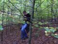
| + | Image:2011-10-16_50_8_mampf_searching.jpg | Must be here somewhere. | ||
| + | Image:2011-10-16_50_8_coords_reached.jpg | Coordinates reached. | ||
| + | Image:2011-10-16_50_8_mampf_grin.jpg | Stupid grin. | ||
| + | Image:2011-10-16_50_8_hash_view.jpg | Look at the hash. | ||
</gallery> | </gallery> | ||
| Line 39: | Line 65: | ||
{{Land geohash | {{Land geohash | ||
| latitude = 50 | | latitude = 50 | ||
| + | | longitude = 8 | ||
| + | | date = 2011-10-16 | ||
| + | | name = Rincewind, Salta, Mampfred, LadyBB and EmmJay | ||
| + | }} | ||
| + | {{Consecutive_geohash | ||
| + | | latitude = 50 | ||
| + | | longitude = 8 | ||
| + | | count = 3 | ||
| + | | date = 2011-10-14 | ||
| + | | name = [[User:Mampfred|Mampfred]] | ||
| + | }} | ||
| + | {{Earliest geohasher | ||
| + | | latitude = 50 | ||
| longitude = 8 | | longitude = 8 | ||
| date = 2011-10-16 | | date = 2011-10-16 | ||
| Line 45: | Line 84: | ||
[[Category:Expeditions]] | [[Category:Expeditions]] | ||
| − | + | [[Category:Expeditions with photos]] | |
[[Category:Coordinates reached]] | [[Category:Coordinates reached]] | ||
Revision as of 07:59, 17 October 2011
| Sun 16 Oct 2011 in 50,8: 50.5873205, 8.3561470 geohashing.info google osm bing/os kml crox |
Location
Outside Ehringshausen in the forest, near a gravel path. Judging from the satellite imagery, quite accessible.
Participants
Plans
Rincewind and Salta
Drive to the end of the village, walk a couple of hundred meters.
Mampfred, LadyBB and EmmJay
We're going to visit dad/granddad and the hash is conveniantly only 10km away from his place. Will take place in the afternoon though.
Expedition
Rincewind and Salta
We didn't get a proper satellite fix somehow and so went to the hilltop first. When we realized it was just 1100m anyway, we took the parking lot for leisure walkers there and started our search. The weather was really beautiful, so walking seemed rather a treat than a duty, anyway.
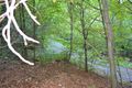
When the forest way didn't go our direction, we went a bit cross-country downhill. We soon found another path that fitted our direction, passed a couple of fish ponds and walked up the hill through the woods. Nearing the coordinates, we crossed the forest again in order to shorten the path. We then did the hash dance and went back on a slightly better route, which didn't force us to any more offroad climbing (the landscape was more or less steep hills, see the nasty accuracy on the satellite fix).
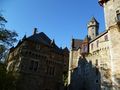
On the way home we made a detour for Castle Braunfels, since we had noticed an indicator sign earlier. We found the castle to be rather huge for a location in the middle of nowhere, and in perfect repair. After gathering some impressions, we went into Braunfels' old city (very beautiful, as well) and had coffee and cake. All in all, one of the last sunny autumn days spent as well as could be. Yeah! And hash success, as a matter of fact. :)
Mampfred, LadyBB and EmmJay
We were late. Very late. So we parked as close to the hash as we could, Mampfred took EmmJay in the carrier and we walked up the hill (did I mention that most of the hashes in our area are up a frigging hill?) as fast as we could. We found the hash right next to the trail and had a bit of trouble getting the exact spot probably due to the thick forest. Went on to visit das/granddad and didn't even notice that the guys above had been there before us ;)
Tracklog
Mampfred, LadyBB and EmmJay took this route.
Photos
Rincewind and Salta
We weren't as fast as the photo suggests...

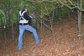
I have to do the "stupid" part, as usually.
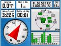
Coordinates reached. Forgot to take a picture of the actual hash point. Oh, well.

Schloss Braunfels from the village below. Quite some dimensions...
A photo from inside the castle.


Mampfred, LadyBB and EmmJay

Mampfred and EmmJay (formerly known as +1).

LadyBB (formerly known as LadyBB+1) is there too.
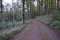
The trail heading to the hash.
Must be here somewhere.
Coordinates reached.

Stupid grin.
Look at the hash.


Achievements
Rincewind, Salta, Mampfred, LadyBB and EmmJay earned the Land geohash achievement
|
Mampfred earned the Consecutive geohash achievement
|
Rincewind and Salta earned the Earliest geohasher achievement
|