Difference between revisions of "2011-10-22 -37 147"
imported>Talex |
m (per Renaming Proposal) |
||
| (14 intermediate revisions by 5 users not shown) | |||
| Line 1: | Line 1: | ||
| − | + | [[Image:2011-10-22_-37_147_09-53-20-777.jpg|thumb|left]] | |
| − | |||
| − | |||
| − | |||
| − | |||
| − | |||
| − | |||
| − | |||
| − | |||
{{meetup graticule | {{meetup graticule | ||
| lat=-37 | | lat=-37 | ||
| Line 14: | Line 6: | ||
}} | }} | ||
| − | + | Success! | |
| + | |||
| + | Oh wait, the geohash droid is giving incorrect readings. Blinded by science! | ||
| + | |||
| + | Oh wait, the geohash droid was right after all, and Carabiner had a bug. (well, sort of). Success! | ||
| + | |||
<!-- edit as necessary --> | <!-- edit as necessary --> | ||
__NOTOC__ | __NOTOC__ | ||
== Location == | == Location == | ||
| − | + | In a paddock, not far from the highway halfway between Bairnsdale and Sale. | |
== Participants == | == Participants == | ||
| − | + | [[User:Stevage|Stevage]], [[User:Talex|Talex]], [[User:Felix Dance|Felix Dance]] | |
| − | == | + | == Expedition == |
| − | + | Steve, tAlex, Felix, and four others, were on a huge two-day bike ride from Bairnsdale to Melbourne. We had 160 km to cover on the Saturday, but still, plenty of time for a geohash right? We forgot to check it in the morning before setting out from Bairnsdale. After an hour or so, we suddenly realised, but couldn't exactly bring the expedition to a grinding halt just for a geohash. An uncomfortable feeling grew - what if the hash was ''right over there''? What if it was a couple of kilometres behind us, rapidly receding into the distance? | |
| − | + | Through the magic of telepathy, Alex and I concocted a plan: I called a snack halt, while 100m up the road Alex sneakily pulled out his phone, and brought up the geohashing app. The happy words were called out "It's just 9 kilometres north of here". Wow...we were heading almost due west, so for the point to be north meant we'd stopped at the ideal moment. | |
| − | + | ||
| + | So, who would come with us to slay the dragon? It all depended on how much unsealed road there was. I squinted at the map, and provided the most accurate estimate available under the circumstances: "Somewhere between zero and nine kilometres of unsealed. Maybe more." This instantly split the group, much to our chagrin. They zoomed off into the distance. Meanwhile we doubled back a couple of hundred metres. | ||
| + | |||
| + | Amazingly, the unsealed road never materialised. Beautiful, narrow, untrafficked, high quality sealed roads were our red carpet. Sulphur-crested cockatoos were our choir. Slightly giddy, we soon found ourselves at a friendly looking paddock fence. No farm houses too near, just an old derelict temporary shelter from decades past. We strode through the wet grass, straight towards where the point was clearly located: in the middle of a dam. Without a word, it was understood we would strip down and dive into the muddy shallows without hesitation. | ||
| + | |||
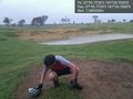
| + | Sadly, the point turned out to be on dry land. But it was a nice spot, under a tree. Quick photos were quickly uploaded, then we jumped back on the bikes and caught up with our friends in Stratford. | ||
| + | |||
| + | From the geohash, we rode approximately 280 kilometres home. I wonder if that's any kind of record? | ||
== Tracklog == | == Tracklog == | ||
| − | + | http://app.strava.com/rides/2080339 | |
| + | |||
| + | (The geohash is around the 47 km mark.) | ||
== Photos == | == Photos == | ||
| − | |||
| − | |||
| − | |||
<gallery perrow="5"> | <gallery perrow="5"> | ||
| Line 47: | Line 50: | ||
<!-- Add any achievement ribbons you earned below, or remove this section --> | <!-- Add any achievement ribbons you earned below, or remove this section --> | ||
| + | {{Graticule unlocked|latitude=-37|longitude=147|date=2011-10-22}} | ||
| + | {{Bicycle geohash|latitude=-37|longitude=147|date=2011-10-22}} | ||
| + | :Well, technically we rode *from* the geohash. But we also rode about 47 km from Bairnsdale to get to it. | ||
| + | {{OpenStreetMap achievement|latitude=-37|longitude=147|date=2011-10-22}} | ||
| − | + | :Added the little road that the geohash is next to, [http://www.openstreetmap.org/?lat=-37.92944&lon=147.34749&zoom=15&layers=M here] | |
| − | |||
| − | |||
| − | |||
| − | |||
| − | |||
| − | |||
| − | |||
| − | |||
[[Category:Expeditions]] | [[Category:Expeditions]] | ||
| − | |||
[[Category:Expeditions with photos]] | [[Category:Expeditions with photos]] | ||
| − | |||
| − | |||
| − | |||
| − | |||
[[Category:Coordinates reached]] | [[Category:Coordinates reached]] | ||
| − | + | {{location|AU|VIC|WE}} | |
| − | |||
| − | |||
| − | |||
| − | |||
| − | |||
| − | |||
| − | |||
| − | |||
| − | |||
Latest revision as of 05:49, 20 March 2024

| Sat 22 Oct 2011 in -37,147: -37.9295437, 147.3459880 geohashing.info google osm bing/os kml crox |
Success!
Oh wait, the geohash droid is giving incorrect readings. Blinded by science!
Oh wait, the geohash droid was right after all, and Carabiner had a bug. (well, sort of). Success!
Location
In a paddock, not far from the highway halfway between Bairnsdale and Sale.
Participants
Expedition
Steve, tAlex, Felix, and four others, were on a huge two-day bike ride from Bairnsdale to Melbourne. We had 160 km to cover on the Saturday, but still, plenty of time for a geohash right? We forgot to check it in the morning before setting out from Bairnsdale. After an hour or so, we suddenly realised, but couldn't exactly bring the expedition to a grinding halt just for a geohash. An uncomfortable feeling grew - what if the hash was right over there? What if it was a couple of kilometres behind us, rapidly receding into the distance?
Through the magic of telepathy, Alex and I concocted a plan: I called a snack halt, while 100m up the road Alex sneakily pulled out his phone, and brought up the geohashing app. The happy words were called out "It's just 9 kilometres north of here". Wow...we were heading almost due west, so for the point to be north meant we'd stopped at the ideal moment.
So, who would come with us to slay the dragon? It all depended on how much unsealed road there was. I squinted at the map, and provided the most accurate estimate available under the circumstances: "Somewhere between zero and nine kilometres of unsealed. Maybe more." This instantly split the group, much to our chagrin. They zoomed off into the distance. Meanwhile we doubled back a couple of hundred metres.
Amazingly, the unsealed road never materialised. Beautiful, narrow, untrafficked, high quality sealed roads were our red carpet. Sulphur-crested cockatoos were our choir. Slightly giddy, we soon found ourselves at a friendly looking paddock fence. No farm houses too near, just an old derelict temporary shelter from decades past. We strode through the wet grass, straight towards where the point was clearly located: in the middle of a dam. Without a word, it was understood we would strip down and dive into the muddy shallows without hesitation.
Sadly, the point turned out to be on dry land. But it was a nice spot, under a tree. Quick photos were quickly uploaded, then we jumped back on the bikes and caught up with our friends in Stratford.
From the geohash, we rode approximately 280 kilometres home. I wonder if that's any kind of record?
Tracklog
http://app.strava.com/rides/2080339
(The geohash is around the 47 km mark.)
Photos
Geohash success @-37.9296,147.3460

Achievements
This user earned the Graticule Unlocked Achievement
|
This user earned the Bicycle geohash achievement
|
- Well, technically we rode *from* the geohash. But we also rode about 47 km from Bairnsdale to get to it.
This user earned the OpenStreetMap achievement
|
- Added the little road that the geohash is next to, here