Difference between revisions of "2011-10-22 43 -87"
imported>RocketMac (→Expedition) |
imported>Eldin (clean up template and check categories.) |
||
| Line 1: | Line 1: | ||
| − | |||
| − | |||
| − | |||
| − | |||
| − | |||
| − | |||
| − | |||
| − | |||
| − | |||
<blockquote>''"Let me put it this way, Mr. Amor. The 9000 series is the most reliable computer ever made. No 9000 computer has ever made a mistake or distorted information. We are all, by any practical definition of the words, foolproof and incapable of error."'' ~HAL, 2001</blockquote> | <blockquote>''"Let me put it this way, Mr. Amor. The 9000 series is the most reliable computer ever made. No 9000 computer has ever made a mistake or distorted information. We are all, by any practical definition of the words, foolproof and incapable of error."'' ~HAL, 2001</blockquote> | ||
| Line 17: | Line 8: | ||
}} | }} | ||
| − | |||
== Location == | == Location == | ||
| − | |||
Just off a small dead-end road in Mequon, WI. | Just off a small dead-end road in Mequon, WI. | ||
== Participants == | == Participants == | ||
| − | |||
*[[User:RocketMac|RocketMac]] | *[[User:RocketMac|RocketMac]] | ||
*MusicGirl - The non-hashing, non-caching wife of RocketMac | *MusicGirl - The non-hashing, non-caching wife of RocketMac | ||
== Plans == | == Plans == | ||
| − | |||
When I looked up the coordinates on Friday, I had mentioned to the wife (MusicGirl) that it might be fun to head up there and see what's there, since it's out of our normal "flight zone" if you will. | When I looked up the coordinates on Friday, I had mentioned to the wife (MusicGirl) that it might be fun to head up there and see what's there, since it's out of our normal "flight zone" if you will. | ||
== Expedition == | == Expedition == | ||
| − | |||
On Saturday morning, I asked MusicGirl what she wanted to do about lunch. She said that she liked me idea of finding my hashpoint and then finding a restaurant nearby to try something new. | On Saturday morning, I asked MusicGirl what she wanted to do about lunch. She said that she liked me idea of finding my hashpoint and then finding a restaurant nearby to try something new. | ||
| Line 56: | Line 42: | ||
== Tracklog == | == Tracklog == | ||
| − | |||
My tracklog is available in [http://coldshadow.com/geohashing/2011-08-22.gpx GPX] and [http://coldshadow.com/geohashing/2011-08-22.kmz KMZ] formats | My tracklog is available in [http://coldshadow.com/geohashing/2011-08-22.gpx GPX] and [http://coldshadow.com/geohashing/2011-08-22.kmz KMZ] formats | ||
== Photos == | == Photos == | ||
| − | |||
| − | |||
| − | |||
<gallery perrow="4"> | <gallery perrow="4"> | ||
Image:2011-10-22 43 -87 01.jpg | Map | Image:2011-10-22 43 -87 01.jpg | Map | ||
| Line 76: | Line 58: | ||
== Achievements == | == Achievements == | ||
{{#vardefine:ribbonwidth|800px}} | {{#vardefine:ribbonwidth|800px}} | ||
| − | + | ||
{{land geohash | {{land geohash | ||
| latitude = 43 | | latitude = 43 | ||
| Line 101: | Line 83: | ||
}} | }} | ||
| − | |||
| − | |||
| − | |||
| − | |||
| − | |||
| − | |||
| − | |||
| − | |||
[[Category:Expeditions]] | [[Category:Expeditions]] | ||
[[Category:Expeditions with photos]] | [[Category:Expeditions with photos]] | ||
| − | + | [[Category:Coordinates not reached]] | |
| − | |||
| − | |||
| − | |||
| − | |||
| − | |||
| − | [[Category:Coordinates reached]] | ||
| − | |||
| − | |||
| − | |||
[[Category:Not reached - Technology]] | [[Category:Not reached - Technology]] | ||
| − | |||
| − | |||
| − | |||
| − | |||
| − | |||
| − | |||
| − | |||
Revision as of 21:06, 12 April 2013
"Let me put it this way, Mr. Amor. The 9000 series is the most reliable computer ever made. No 9000 computer has ever made a mistake or distorted information. We are all, by any practical definition of the words, foolproof and incapable of error." ~HAL, 2001
| Sat 22 Oct 2011 in 43,-87: 43.9295437, -87.3459880 geohashing.info google osm bing/os kml crox |
Contents
Location
Just off a small dead-end road in Mequon, WI.
Participants
- RocketMac
- MusicGirl - The non-hashing, non-caching wife of RocketMac
Plans
When I looked up the coordinates on Friday, I had mentioned to the wife (MusicGirl) that it might be fun to head up there and see what's there, since it's out of our normal "flight zone" if you will.
Expedition
On Saturday morning, I asked MusicGirl what she wanted to do about lunch. She said that she liked me idea of finding my hashpoint and then finding a restaurant nearby to try something new.
My original iPhone geoashing app is refusing to give coordinates for Friday, Saturday, or Sunday; but I can look up coordinates any other day/year. Odd. I took the precaution of loading the waypoint off the day's page into my best GPS app and we head out.
The drive up was relatively uneventful. We pulled up near the hashpoint and MusicGirl politely decided to stay in the car and look for our lunch options.
I got out and walked over to the spot. Every time I go out geohashing, I realize I need to find a better GPS app, one that updates more frequently. After a little zigging and zagging, I confirmed that I had made the spot. I took some pictures and went back to the car.
MusicGirl and I started digging through Yelp! to find lunch options. We found a place called Cafe 1505 nearby. The place was fine, but the pictures on the web site and the descriptions in the menu painted a more glamourous image than reality provided. There was a seafood place that was technically in line of sight that would have counted for a Pub Geohash but it's a seafood place and that would have been a hard sell to MusicGirl.
After that we started our way home. We had to make a couple of shopping runs that are now immortalized in my tracklog, but so be it.
**Error! Does Not Compute!**
As previously mentioned, my geohashing app on my iPhone wasn't giving data for the days covered by Friday's DOW opening, but everything else was fine. I had pulled the hashpoint data straight off the web site.
But when I started creating the expedition page, I had a very different set of coordinates on the map. I checked again and those numbers stuck. I was starting to think I had entered the wrong date into the site this morning, but then I realized I had pulled up those coordinates on the web site on two other occassions with the same result.
I checked my geohashing app and suddenly I had data! Huh!
The only thing I can figure is that the DOW data wasn't available but the site was still hashing the rest of the string. I had *just* seen another expedition page with an alternate point on the map, so I spent some time figuring out this "proposed alternate location" thing and decided to log the journey anyway.
Tracklog
My tracklog is available in GPX and KMZ formats
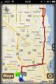
Photos
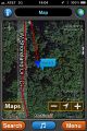
Map
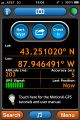
GPS Reading

At the point with MusicGirl in the car back there
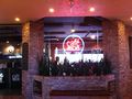
Cafe 1505

RocketMac and MusicGirl at Cafe 1505

Yelp! Checkin
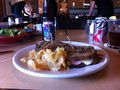
Lunch and Beer
GPS Route


Achievements
RocketMac earned the Land geohash achievement
|
RocketMac earned the Drag-along achievement
|
RocketMac earned the Blinded by Science Consolation Prize
|