Difference between revisions of "2011-10-25 48 9"
imported>Ekorren (Is this a plan?) |
imported>Ekorren (Report and gallery) |
||
| Line 8: | Line 8: | ||
Tübingen - Waldhäuser Ost. Just at the side of a road between lots of large buildings. | Tübingen - Waldhäuser Ost. Just at the side of a road between lots of large buildings. | ||
| + | |||
| + | Waldhäuser Ost ("East of Waldhausen") is a suburb which was mostly built in the 1960s and 1970s, a time when it was considered modern to build concrete cubes that would allow to efficiently pack as many people as possible into one package. Also, to make sure that it's most inconvenient to reach by reasonable transport, such a district had to be built on top of a mountain, far away from any railway, and connected to the city only by large highways. To increase the psychological effect of feeling outcast, people living there should preferrably be such who can't afford a car, like students and poor families. | ||
| + | |||
| + | However, at least they have a decent bus connection nowadays. Before 1984, I wouldn't call it decent, though. | ||
== Participants == | == Participants == | ||
| − | [[User:Ekorren|Ekorren]] | + | [[User:Ekorren|Ekorren]] has been there in the afternoon. |
[[User:Steingesicht|Steingesicht]] might visit the point in the evening. | [[User:Steingesicht|Steingesicht]] might visit the point in the evening. | ||
| − | |||
| − | + | == Expedition by Ekorren == | |
| − | + | These days are kind of hectical... however, the hash was ''so close'' that I simply couldn't skip it. So, after getting the most urgent obligations out of my way, I jumped on the bike and moved upwards. There isn't really more to tell. | |
| + | Since I have been travelling the ''Berliner Ring'' road very many times, by bus, bike and foot, and also the ''Weißdornweg'' a few times, I'm claiming another ''deja vu'' geohash for this. I'm not sure I have proof somewhere, though. | ||
| + | |||
| + | === Gallery === | ||
| + | ''Seems I forgot to disable the macro mode. Sorry for the blurred photos. However, I don't think the area would look much nicer if sharper ;)'' | ||
| + | <gallery> | ||
| + | File:2011-10-25_48_9_e_Hash.JPG|View on hash | ||
| + | File:2011-10-25_48_9_e_GPS.JPG|Coordinates | ||
| + | File:2011-10-25_48_9_e_VFH_1.JPG|Views from hash | ||
| + | File:2011-10-25_48_9_e_VFH_2.JPG | ||
| + | File:2011-10-25_48_9_e_VFH_3.JPG | ||
| + | File:2011-10-25_48_9_e_ACAB.JPG|Sticker almost at hash. Given the experiences of the last 1.5 years, I tend to agree. | ||
| + | </gallery> | ||
| + | == Expedition by Steingesicht == | ||
| − | == Gallery == | + | === Gallery === |
<gallery> | <gallery> | ||
</gallery> | </gallery> | ||
| − | |||
| − | |||
[[Category:Expeditions]] | [[Category:Expeditions]] | ||
[[Category:Expeditions with photos]] | [[Category:Expeditions with photos]] | ||
[[Category:Coordinates reached]] | [[Category:Coordinates reached]] | ||
| − | |||
Revision as of 15:21, 25 October 2011
| Tue 25 Oct 2011 in 48,9: 48.5438548, 9.0579696 geohashing.info google osm bing/os kml crox |
Contents
Location
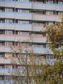
Tübingen - Waldhäuser Ost. Just at the side of a road between lots of large buildings.
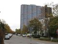
Waldhäuser Ost ("East of Waldhausen") is a suburb which was mostly built in the 1960s and 1970s, a time when it was considered modern to build concrete cubes that would allow to efficiently pack as many people as possible into one package. Also, to make sure that it's most inconvenient to reach by reasonable transport, such a district had to be built on top of a mountain, far away from any railway, and connected to the city only by large highways. To increase the psychological effect of feeling outcast, people living there should preferrably be such who can't afford a car, like students and poor families.
However, at least they have a decent bus connection nowadays. Before 1984, I wouldn't call it decent, though.
Participants
Ekorren has been there in the afternoon.
Steingesicht might visit the point in the evening.
Expedition by Ekorren
These days are kind of hectical... however, the hash was so close that I simply couldn't skip it. So, after getting the most urgent obligations out of my way, I jumped on the bike and moved upwards. There isn't really more to tell.
Since I have been travelling the Berliner Ring road very many times, by bus, bike and foot, and also the Weißdornweg a few times, I'm claiming another deja vu geohash for this. I'm not sure I have proof somewhere, though.
Gallery
Seems I forgot to disable the macro mode. Sorry for the blurred photos. However, I don't think the area would look much nicer if sharper ;)
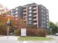
View on hash
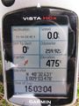
Coordinates
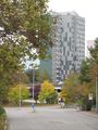
Views from hash

Sticker almost at hash. Given the experiences of the last 1.5 years, I tend to agree.


