Difference between revisions of "2011-10-29 41 -88"
From Geohashing
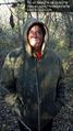
imported>EvilUncleNomo ([live picture] Evil Uncle Nomo [http://www.openstreetmap.org/?lat=41.54961901666667&lon=-88.0635762&zoom=16&layers=B000FTF @41.5496,-88.0636]) |
imported>EvilUncleNomo ([live picture] Wife [http://www.openstreetmap.org/?lat=41.5496189&lon=-88.06357631666667&zoom=16&layers=B000FTF @41.5496,-88.0636]) |
||
| Line 41: | Line 41: | ||
Image:2011-10-29_41_-88_16-11-05-056.jpg | Evil Uncle Nomo [http://www.openstreetmap.org/?lat=41.54961901666667&lon=-88.0635762&zoom=16&layers=B000FTF @41.5496,-88.0636] | Image:2011-10-29_41_-88_16-11-05-056.jpg | Evil Uncle Nomo [http://www.openstreetmap.org/?lat=41.54961901666667&lon=-88.0635762&zoom=16&layers=B000FTF @41.5496,-88.0636] | ||
| + | |||
| + | Image:2011-10-29_41_-88_16-11-37-085.jpg | Wife [http://www.openstreetmap.org/?lat=41.5496189&lon=-88.06357631666667&zoom=16&layers=B000FTF @41.5496,-88.0636] | ||
</gallery> | </gallery> | ||
Revision as of 21:11, 29 October 2011
| Sat 29 Oct 2011 in 41,-88: 41.5496219, -88.0636164 geohashing.info google osm bing/os kml crox |
Location
A patch of woods behind a suburb in Joliet, Illinois, U.S.A.
Participants
- EvilUncleNomo and wife
Plans
- EvilUncleNomo and wife are planning on attempting this geohash Saturday afternoon. Hopefully there will be no swamp hiding in the forest this time.
Expedition
Tracklog
Photos

Failure? Not yet! @41.5504,-88.0630

Evil Uncle Nomo @41.5496,-88.0636
Wife @41.5496,-88.0636


Achievements