Difference between revisions of "2011-10-29 55 13"
imported>Fasanen |
imported>Fasanen (Expedition report) |
||
| Line 1: | Line 1: | ||
| − | |||
| − | |||
| − | |||
| − | |||
| − | |||
| − | |||
| − | |||
| − | |||
| − | |||
{{meetup graticule | {{meetup graticule | ||
| lat=55 | | lat=55 | ||
| Line 14: | Line 5: | ||
}} | }} | ||
| − | |||
__NOTOC__ | __NOTOC__ | ||
== Location == | == Location == | ||
| − | + | 6th hole, Oxie golf course | |
== Participants == | == Participants == | ||
| − | + | * [[User:Fasanen|Fasanen]] & Mr.T | |
| − | |||
| − | |||
| − | |||
== Expedition == | == Expedition == | ||
| − | + | Our main goal today was C4-open, a scale-modelling event and competition held in Malmö. After having seen a tremendous amount of impressing creations we headed back home. The timing (Saturday meet up time) was good as we also happened to pass today’s geohash location; the fairway on the sixth hole of Oxie golf course. | |
| − | + | The fog was heavy and it was chilly as we walked quickly over the course. A lonely golfer was moving like a ghost in the distant as we reached the geohash. We placed a golf ball as a marker and waited a few minutes in case any other geohasher would show up. No one came, so we called it a day and went home to begin assemblying the model we had purchased; a 1/35 Finnish version of a Stumgeschütz III. | |
| − | |||
== Photos == | == Photos == | ||
| − | + | <gallery perrow="4"> | |
| + | Image:201110295513 01.JPG | The tee at the 6th hole at... | ||
| + | Image:201110295513 02.JPG | ...Oxie GK | ||
| + | Image:201110295513 03.JPG | Man made water hazard and Mr.T. | ||
| + | Image:201110295513 04.JPG | The fog was thick. | ||
| + | Image:201110295513 05.JPG | Photogenic clumps of reed. | ||
| + | Image:201110295513 06.JPG | We left a marker. | ||
| + | Image:201110295513 07.png | Proof | ||
| + | </gallery> | ||
== Achievements == | == Achievements == | ||
{{#vardefine:ribbonwidth|800px}} | {{#vardefine:ribbonwidth|800px}} | ||
| − | + | {{land geohash | latitude=55 | longitude=13 | date=2011-10-29 | name=Fasanen & Mr.T}} | |
| + | {{Golf geohash | latitude = 55 | longitude = 13| date = 2011-10-29 | name = [[User:Fasanen|Fasanen]] & Mr.T }} | ||
[[Category:Expeditions]] | [[Category:Expeditions]] | ||
Revision as of 21:17, 14 November 2011
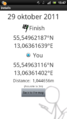
| Sat 29 Oct 2011 in 55,13: 55.5496219, 13.0636164 geohashing.info google osm bing/os kml crox |
Location
6th hole, Oxie golf course
Participants
- Fasanen & Mr.T
Expedition
Our main goal today was C4-open, a scale-modelling event and competition held in Malmö. After having seen a tremendous amount of impressing creations we headed back home. The timing (Saturday meet up time) was good as we also happened to pass today’s geohash location; the fairway on the sixth hole of Oxie golf course.
The fog was heavy and it was chilly as we walked quickly over the course. A lonely golfer was moving like a ghost in the distant as we reached the geohash. We placed a golf ball as a marker and waited a few minutes in case any other geohasher would show up. No one came, so we called it a day and went home to begin assemblying the model we had purchased; a 1/35 Finnish version of a Stumgeschütz III.
Photos
The tee at the 6th hole at...

...Oxie GK
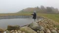
Man made water hazard and Mr.T.
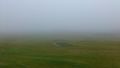
The fog was thick.
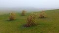
Photogenic clumps of reed.

We left a marker.
Proof


Achievements
Fasanen & Mr.T earned the Land geohash achievement
|
Fasanen & Mr.T earned the Golf Geohash Achievement
|