Difference between revisions of "2011-10-30 -37 148"
imported>Stevage (→Achievements) |
(→Expedition) |
||
| (7 intermediate revisions by 6 users not shown) | |||
| Line 1: | Line 1: | ||
| − | + | [[File:2011 10 30 -37 148 Amigos.JPG|thumb|left|200px]] | |
| − | |||
| − | |||
| − | |||
| − | |||
| − | |||
| − | |||
| − | |||
{{meetup graticule | {{meetup graticule | ||
| lat=-37 | | lat=-37 | ||
| Line 23: | Line 16: | ||
== Expedition == | == Expedition == | ||
| − | After a psychotic mountain biking adventure was mercifully ended by the destruction of my derailleur hanger, we had more time for geohashing. We'd | + | |
| + | After a psychotic mountain biking adventure was mercifully ended by the destruction of my derailleur hanger, we had more time for geohashing. We'd unlocked this graticule a long time ago, before shoving bikes up hill, camping in a structurally unsound | ||
| + | tent, and eating instant mashed potato had wearied us: yesterday. | ||
Driving from the national park we encountered a freshly fallen tree across our path, then a bull too stupid to get off the road, followed by a suicidal kookaburra. We passed through the rather eccentric Seldom Seen Servo, and saw a wombat scurry off the road. | Driving from the national park we encountered a freshly fallen tree across our path, then a bull too stupid to get off the road, followed by a suicidal kookaburra. We passed through the rather eccentric Seldom Seen Servo, and saw a wombat scurry off the road. | ||
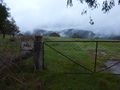
| − | There were two possible routes from the main road: from the north or the south, both quite indirect, and both probably involving four wheel drive tracks. We looked for the first. It ended very quickly in a locked gate. In any case, it was getting late, and the only food option within a thousand kilometres was about to close. Eep | + | There were two possible routes from the main road: from the north or the south, both quite indirect, and both probably involving four wheel drive tracks. We looked for the first. It ended very quickly in a locked gate. In any case, it was getting late, and the only food option within a thousand kilometres was about to close. |
| + | [[File:2011-10-30 -37 148 bull.jpg|thumb|200px|left|Moo....]] | ||
| + | Eep! Dinner at the Buchan Pub first, geohash second. | ||
Full of parmas and lasagne, we resumed our quest. The second approach led for a long way down a nice, minor road, then exploded into a pile of choices. The four wheel drive track in question was not an option for our humble vehicle, so we set off on foot. The point was in some bush, outside a paddock. We crept closer, following a fenceline, trying to minimise the bushbashing. Alex and Steve kept Felix constantly updated on our location, competing to give the most optimistic news. | Full of parmas and lasagne, we resumed our quest. The second approach led for a long way down a nice, minor road, then exploded into a pile of choices. The four wheel drive track in question was not an option for our humble vehicle, so we set off on foot. The point was in some bush, outside a paddock. We crept closer, following a fenceline, trying to minimise the bushbashing. Alex and Steve kept Felix constantly updated on our location, competing to give the most optimistic news. | ||
| Line 37: | Line 34: | ||
== Photos == | == Photos == | ||
| − | + | ||
| − | |||
| − | |||
<gallery perrow="5"> | <gallery perrow="5"> | ||
| Line 54: | Line 49: | ||
== Achievements == | == Achievements == | ||
{{#vardefine:ribbonwidth|800px}} | {{#vardefine:ribbonwidth|800px}} | ||
| − | {{OpenStreetMap | + | |
| − | + | {{Land geohash|latitude=-37|longitude=148|date=2011-10-30}} | |
| + | {{OpenStreetMap achievement|latitude=-37|longitude=148|date=2011-10-30|OSMlink=9709415}} | ||
| + | |||
| Line 61: | Line 58: | ||
[[Category:Expeditions with photos]] | [[Category:Expeditions with photos]] | ||
[[Category:Coordinates reached]] | [[Category:Coordinates reached]] | ||
| + | {{location|AU|VIC|EG}} | ||
Latest revision as of 23:50, 28 April 2024

| Sun 30 Oct 2011 in -37,148: -37.3749477, 148.1264146 geohashing.info google osm bing/os kml crox |
Location
In the bush, near W Tree, southeastern Victoria.
Participants
Expedition
After a psychotic mountain biking adventure was mercifully ended by the destruction of my derailleur hanger, we had more time for geohashing. We'd unlocked this graticule a long time ago, before shoving bikes up hill, camping in a structurally unsound tent, and eating instant mashed potato had wearied us: yesterday.
Driving from the national park we encountered a freshly fallen tree across our path, then a bull too stupid to get off the road, followed by a suicidal kookaburra. We passed through the rather eccentric Seldom Seen Servo, and saw a wombat scurry off the road.
There were two possible routes from the main road: from the north or the south, both quite indirect, and both probably involving four wheel drive tracks. We looked for the first. It ended very quickly in a locked gate. In any case, it was getting late, and the only food option within a thousand kilometres was about to close.

Eep! Dinner at the Buchan Pub first, geohash second.
Full of parmas and lasagne, we resumed our quest. The second approach led for a long way down a nice, minor road, then exploded into a pile of choices. The four wheel drive track in question was not an option for our humble vehicle, so we set off on foot. The point was in some bush, outside a paddock. We crept closer, following a fenceline, trying to minimise the bushbashing. Alex and Steve kept Felix constantly updated on our location, competing to give the most optimistic news.
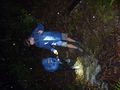
At 250 metres, we began the assault. It wasn't raining, but the vegetation was very, very wet. We tripped, stumbled, hacked, bashed, mashed, crushed, bumbled and crunched our way through bracken, over fallen logs, and around the odd impassable tree. Felix estimated the number of leeches we'd pick up: 12. (I guessed 4. Alex guessed NULL. It was 0.) For once, we made a pretty direct line towards the point. The usual rituals, then we stormed the hell out of there and back to somewhere drier.
Tracklog
Photos

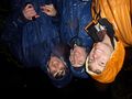
Geohash success, terrible photo but better to follow.
No Shooting!
Crossing a mighty river
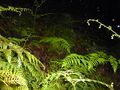
Ferny surroundings
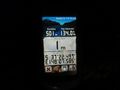
GPS proof
Talex, Stevage and Felix Dance


Achievements
This user earned the Land geohash achievement
|
This user earned the OpenStreetMap achievement
|