Difference between revisions of "2011-10-30 47 8"
imported>TheOneRing (Created page with "{{meetup graticule | lat=47 | lon=8 | date=2011-10-30 }} == Location == The geohash is in a forest near Hunzenschwil (canton Aargau) == Participants == [[User:TheOneRing|TheOne...") |
imported>TheOneRing |
||
| Line 11: | Line 11: | ||
[[User:TheOneRing|TheOneRing]] - by public transport. | [[User:TheOneRing|TheOneRing]] - by public transport. | ||
| − | == The | + | == The Expedition == |
=== TheOneRing === | === TheOneRing === | ||
| − | + | After more than month after the last planned geohash, which was beyond that unsuccessful, I desperately wanted to go. I got the train from Berne to Zofingen and from there to Hunzenschwil. The weather on the way was cloudy, but it looked ok. In Hunzenschwil it was still cloudy but surprisingly warm. | |
| + | |||
| + | The way to the geohash was 1.5 km as the bird flies and by foot it was not much more. After walking across the forest near the geohash I recognised that there also was a forest track; I could have done easier. The surrounding at the geohash was very forest-like: trees, leaves and mushrooms. | ||
| + | |||
| + | After taking the usual photographs I walked back to Hunzenschwil, took more photos and went back to Berne. It was a nice little trip on a nice day. | ||
| + | |||
| + | == Photos == | ||
| + | === TheOneRing === | ||
| + | <gallery perrow="3"> | ||
| + | Image:20111030GPS.jpg|The proof that I reached the right coordinates... | ||
| + | Image:20111030Ticket.jpg|...on the right date | ||
| + | Image:20111030Bahnhof.jpg|The train station of Hunzenschwil | ||
| + | Image:20111030Train.jpg|The train to and from Hunzenschwil | ||
| + | Image:20111030Geohash.jpg|View to the Geohash | ||
| + | Image:20111030Hunzenschwil.jpg|Panoramic view of Hunzenschwil | ||
| + | Image:20111030Me.jpg|Stupid Grin | ||
| + | Image:20111030Surrounding1.jpg|View in the forest... | ||
| + | Image:20111030Surrounding2.jpg|...and along the forest track | ||
| + | </gallery> | ||
| + | |||
| + | == Achievements == | ||
| + | |||
| + | [[Category:Expeditions]] | ||
| + | [[Category:Expeditions with photos]] | ||
| + | [[Category:Coordinates reached]] | ||
Revision as of 16:59, 30 October 2011
| Sun 30 Oct 2011 in 47,8: 47.3749477, 8.1264146 geohashing.info google osm bing/os kml crox |
Contents
Location
The geohash is in a forest near Hunzenschwil (canton Aargau)
Participants
TheOneRing - by public transport.
The Expedition
TheOneRing
After more than month after the last planned geohash, which was beyond that unsuccessful, I desperately wanted to go. I got the train from Berne to Zofingen and from there to Hunzenschwil. The weather on the way was cloudy, but it looked ok. In Hunzenschwil it was still cloudy but surprisingly warm.
The way to the geohash was 1.5 km as the bird flies and by foot it was not much more. After walking across the forest near the geohash I recognised that there also was a forest track; I could have done easier. The surrounding at the geohash was very forest-like: trees, leaves and mushrooms.
After taking the usual photographs I walked back to Hunzenschwil, took more photos and went back to Berne. It was a nice little trip on a nice day.
Photos
TheOneRing
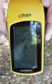
The proof that I reached the right coordinates...
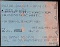
...on the right date
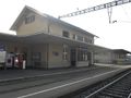
The train station of Hunzenschwil
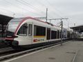
The train to and from Hunzenschwil
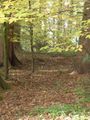
View to the Geohash
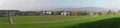
Panoramic view of Hunzenschwil

Stupid Grin
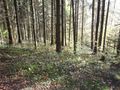
View in the forest...
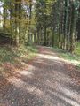
...and along the forest track


