Difference between revisions of "2011-12-13 -38 145"
imported>NWoodruff (→Felix Dance) |
imported>NWoodruff (→Photos) |
||
| Line 32: | Line 32: | ||
Image:Geohash 2011 12 13 -38 145 GPS.JPG|GPS | Image:Geohash 2011 12 13 -38 145 GPS.JPG|GPS | ||
Image:Geohash 2011 12 13 -38 145 Ocean.JPG|Ocean view | Image:Geohash 2011 12 13 -38 145 Ocean.JPG|Ocean view | ||
| − | Image:Geohash 2011 12 13 - | + | Image:Geohash 2011 12 13 -37 145 Kangaroo.JPG|Kangaroo! |
</gallery> | </gallery> | ||
Revision as of 14:09, 9 April 2012
| Tue 13 Dec 2011 in -38,145: -38.6452692, 145.6865925 geohashing.info google osm bing/os kml crox |
Location
In a field overlooking the ocean, near the RACV resort in Inverloch.
Who went
Expedition
Felix Dance
Well annoyingly, I seem to have failed to saved the page after I finished it. I'm going to see if it's still saved in my browser history at work. I just kept clicking Show Preview until I closed down the browser. How annoying.
Just before heading home from work at the desalination plant in Wonthaggi, I noticed that the geohash point for the day was extremely accessible - almost suspiciously so. Riding home with German workmate Nicola, I turned off mysteriously at an intersection outside my now hometown of Inverloch towards the hash. After some navigational issues spawned from the access road on Google Maps in fact being a private driveway, I was bike-clambouring my way up the dunes to an exclusive RACV coastal resort.
After negotiating a caravan park and tying up my bike I scaled a barbed wire fence into the undeveloped bushland of a dry valley. From here I hurtled towards the hash point, with mere metres to go. Sadly, after crossing a recently ploughed field, I found myself confronting a serious barbed wire and triple-electrified fence (and I don't just mean three-phase!). Also threatening the hash were several bulls looking on at me warily from the hash-field, although I judged I could probably be in, at the hash and out in the time they had to charge me.
Using local resources to climb the unfriendly fence without getting electrocuted, I quickly sauntered over to the hash, took some photos and got back to the safe side before the bulls could amass in too great-a-number over the nearby hill. Strutting back to my bike I tried to catch some kangas with my camera, but in the end just cycled off to my friend's birthday dinner party across town.
Here is the Google Maps route I took.
Photos
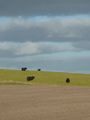
Bulls in the field
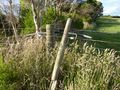
Fence clambouring
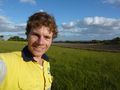
Self-portrait
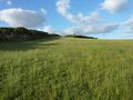
North view
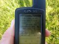
GPS
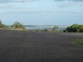
Ocean view
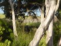
Kangaroo!


