Difference between revisions of "2011-12-17 33 -84"
imported>NWoodruff (Created page with "{{meetup graticule | map=<map lat="33" lon="-84" date="2011-12-17" /> | lat=33 | lon=-84 | date=2011-12-17 | graticule_name=Atlanta | graticule_link=Atlanta, Georgia }} == Grat...") |
imported>FippeBot m (Location) |
||
| (2 intermediate revisions by one other user not shown) | |||
| Line 19: | Line 19: | ||
=== [[User:NWoodruff|NWoodruff]] === | === [[User:NWoodruff|NWoodruff]] === | ||
| + | |||
| + | I drove to this park that was only 12 miles from my home. I noticed on Google maps that it had a bicycle path to ride that was about a mile long. So, I grabbed my bicycle and arrived early to get in a few laps. That is the reason why I also had my bicycle computer in the pictures. | ||
| + | |||
| + | After a few laps, I put my bike back in my truck and walked to the hash spot. I snapped a few pictures and waited till 4pm. I snapped off a few more pictures then my way back to my truck and then home to Norcross. | ||
== Gallery == | == Gallery == | ||
<gallery perrow="3"> | <gallery perrow="3"> | ||
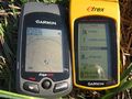
| − | Image:2011121733-84NW01.JPG | | + | Image:2011121733-84NW01.JPG | 0.00 feet to go. The exact spot. |
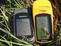
| + | Image:2011121733-84NW02.JPG | Although I was a few minutes early. | ||
| + | Image:2011121733-84NW03.JPG | Looking out towards the street with me sitting on the exact geohash spot waiting for 4pm to roll around. | ||
| + | Image:2011121733-84NW04.JPG | Looking east sitting on the geohash spot. | ||
| + | Image:2011121733-84NW05.JPG | Looking north with me sitting on the geohash spot. | ||
| + | Image:2011121733-84NW06.JPG | Me sitting on the geohash spot with a Stupid Grin™ in dire need of a shave and a hair cut. | ||
| + | Image:2011121733-84NW07.JPG | Ah... Exactly at 4pm. | ||
| + | Image:2011121733-84NW08.JPG | Yep, still at the hash spot. | ||
| + | Image:2011121733-84NW09.JPG | The entrance sign to Alexander Park. | ||
| + | Image:2011121733-84NW10.JPG | Where I parked my truck. | ||
</gallery> | </gallery> | ||
| Line 30: | Line 43: | ||
[[Category:Expeditions with photos]] | [[Category:Expeditions with photos]] | ||
[[Category:Coordinates reached]] | [[Category:Coordinates reached]] | ||
| + | {{location|US|GA|GW}} | ||
Latest revision as of 01:45, 13 August 2019
| Sat 17 Dec 2011 in Atlanta: 33.9144076, -84.0034926 geohashing.info google osm bing/os kml crox |
Graticule
About
In the middle of Alexander Park in Lawrenceville.
Expedition
NWoodruff
I drove to this park that was only 12 miles from my home. I noticed on Google maps that it had a bicycle path to ride that was about a mile long. So, I grabbed my bicycle and arrived early to get in a few laps. That is the reason why I also had my bicycle computer in the pictures.
After a few laps, I put my bike back in my truck and walked to the hash spot. I snapped a few pictures and waited till 4pm. I snapped off a few more pictures then my way back to my truck and then home to Norcross.
Gallery
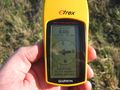
0.00 feet to go. The exact spot.
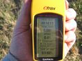
Although I was a few minutes early.
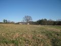
Looking out towards the street with me sitting on the exact geohash spot waiting for 4pm to roll around.
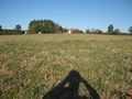
Looking east sitting on the geohash spot.

Looking north with me sitting on the geohash spot.
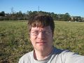
Me sitting on the geohash spot with a Stupid Grin™ in dire need of a shave and a hair cut.
Ah... Exactly at 4pm.
Yep, still at the hash spot.
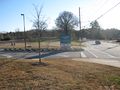
The entrance sign to Alexander Park.
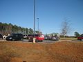
Where I parked my truck.


