Difference between revisions of "2011-12-27 -36 149"
From Geohashing
imported>Jiml m (Result codes look right) |
imported>Eldin (add achievement ribbons) |
||
| Line 50: | Line 50: | ||
<!-- Add any achievement ribbons you earned below, or remove this section --> | <!-- Add any achievement ribbons you earned below, or remove this section --> | ||
| − | + | {{Land geohash | latitude = -36 | longitude = 147 | date = 2011-12-27 | name = [[User:Talex|Talex]]}} | |
| + | {{Virgin graticule | latitude = -36 | longitude = 147 | date = 2011-12-27 | name = [[User:Talex|Talex]]}} | ||
Revision as of 07:38, 3 July 2013
| Tue 27 Dec 2011 in -36,149: -36.6897030, 149.9732629 geohashing.info google osm bing/os kml crox |
Location
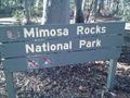
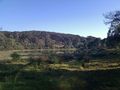
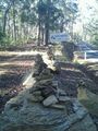
In spotted gum forest in the Mimosa Rocks National Park north of Mogareeka
Participants
Expedition
I had been staying in Tathra for family Christmas and couldn't believe my luck when there was a hash only 5.5km from town. As we were driving back home that day, I got up early and walked 6.5km there and back before 9am. -Talex -Talex
- Coordinates reached! -- Talex @-36.6897,149.9732 07:59, 27 December 2011 (GMT+10:00)
Photos
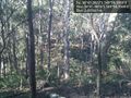
View from hash point of spotted gun forest @-36.6897,149.9732
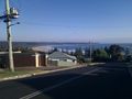
Early morning sea views


Achievements
Talex earned the Land geohash achievement
|