Difference between revisions of "2011-12-27 -36 149"
From Geohashing
imported>Talex (An expedition message sent via Geohash Droid for Android.) |
m (per Renaming Proposal) |
||
| (16 intermediate revisions by 6 users not shown) | |||
| Line 1: | Line 1: | ||
| − | |||
<!-- If you did not specify these parameters in the template, please substitute appropriate values for IMAGE, LAT, LON, and DATE (YYYY-MM-DD format) | <!-- If you did not specify these parameters in the template, please substitute appropriate values for IMAGE, LAT, LON, and DATE (YYYY-MM-DD format) | ||
| Line 15: | Line 14: | ||
}} | }} | ||
| − | + | ||
__NOTOC__ | __NOTOC__ | ||
== Location == | == Location == | ||
| − | + | In spotted gum forest in the Mimosa Rocks National Park north of Mogareeka | |
== Participants == | == Participants == | ||
| − | + | * [[User:Talex|Talex]] | |
| − | |||
| − | |||
== Expedition == | == Expedition == | ||
| − | + | I had been staying in Tathra for family Christmas and couldn't believe my luck when there was a hash only 5.5km from town. As we were driving back home that day, I got up early and walked 6.5km there and back before 9am. -[[User:Talex|Talex]] -Talex | |
| − | == | + | *Coordinates reached! -- [[User:Talex|Talex]] [http://www.openstreetmap.org/?lat=-36.68969376&lon=149.97324353&zoom=16&layers=B000FTF @-36.6897,149.9732] 07:59, 27 December 2011 (GMT+10:00) |
| − | |||
== Photos == | == Photos == | ||
| − | + | ||
| − | + | ||
| − | |||
<gallery perrow="5"> | <gallery perrow="5"> | ||
| + | |||
| + | Image:2011-12-27_-36_149_08-00-41-019.jpg | View from hash point of spotted gun forest [http://www.openstreetmap.org/?lat=-36.68969322&lon=149.97324339&zoom=16&layers=B000FTF @-36.6897,149.9732] | ||
| + | |||
| + | Image:2011-12-27_-36_149_08-02-26-264.jpg | [http://www.openstreetmap.org/?lat=-36.68969180&lon=149.97324338&zoom=16&layers=B000FTF @-36.6897,149.9732] | ||
| + | |||
| + | Image:2011-12-27_-36_149_09-22-44-859.jpg | Early morning sea views | ||
| + | |||
| + | Image:2011-12-27_-36_149_09-23-55-728.jpg | | ||
| + | |||
| + | Image:2011-12-27_-36_149_09-25-43-289.jpg | | ||
| + | |||
| + | Image:2011-12-27_-36_149_09-26-47-349.jpg | | ||
</gallery> | </gallery> | ||
| Line 43: | Line 50: | ||
<!-- Add any achievement ribbons you earned below, or remove this section --> | <!-- Add any achievement ribbons you earned below, or remove this section --> | ||
| + | {{Land geohash | latitude = -36 | longitude = 149 | date = 2011-12-27 | name = [[User:Talex|Talex]]}} | ||
| + | {{Graticule unlocked | latitude = -36 | longitude = 149 | date = 2011-12-27 | name = [[User:Talex|Talex]]}} | ||
| − | |||
| − | |||
| − | |||
| − | |||
| − | |||
| − | |||
| − | |||
| − | |||
| − | |||
[[Category:Expeditions]] | [[Category:Expeditions]] | ||
| − | |||
[[Category:Expeditions with photos]] | [[Category:Expeditions with photos]] | ||
| − | |||
| − | |||
| − | |||
| − | |||
| − | |||
[[Category:Coordinates reached]] | [[Category:Coordinates reached]] | ||
| − | + | {{location|AU|NSW|BV}} | |
| − | |||
| − | |||
| − | |||
| − | |||
| − | |||
| − | |||
| − | |||
| − | |||
| − | |||
Latest revision as of 05:47, 20 March 2024
| Tue 27 Dec 2011 in -36,149: -36.6897030, 149.9732629 geohashing.info google osm bing/os kml crox |
Location
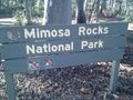
In spotted gum forest in the Mimosa Rocks National Park north of Mogareeka
Participants
Expedition
I had been staying in Tathra for family Christmas and couldn't believe my luck when there was a hash only 5.5km from town. As we were driving back home that day, I got up early and walked 6.5km there and back before 9am. -Talex -Talex
- Coordinates reached! -- Talex @-36.6897,149.9732 07:59, 27 December 2011 (GMT+10:00)
Photos

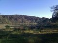
View from hash point of spotted gun forest @-36.6897,149.9732

Early morning sea views


Achievements
Talex earned the Land geohash achievement
|
Talex earned the Graticule Unlocked Achievement
|