Difference between revisions of "2011-12-27 57 11"
From Geohashing
imported>Cjk (→Achievements) |
imported>FippeBot m (Location) |
||
| (2 intermediate revisions by 2 users not shown) | |||
| Line 13: | Line 13: | ||
== Expedition == | == Expedition == | ||
| − | I checked the geohash for the day by chance, and by blinding luck the spot was a few hundred meters from my [https://maps.google.com/maps?q=57.69069,+11.97300+(Old+ | + | I checked the geohash for the day by chance, and by blinding luck the spot was a few hundred meters from my [https://maps.google.com/maps?q=57.69069,+11.97300+(Old+Apartment)&hl=en&ll=57.69079,11.972995&spn=0.0007,0.001725&sll=57.690691,11.972995&sspn=0.0007,0.001725&vpsrc=6&t=h&z=19&iwloc=A old apartment] and even closer to the entrance of my old University, just on the grassy part between the Student Union Building and the tram stop at Chalmers Technical University. |
So I hopped in my car and drove there and took some pictures. Being this close to the winter solstice means the sun has gone down before 1600 so they are a bit dark so I had to use whatever lighting there was, i.e. the illumination of the big tree there. | So I hopped in my car and drove there and took some pictures. Being this close to the winter solstice means the sun has gone down before 1600 so they are a bit dark so I had to use whatever lighting there was, i.e. the illumination of the big tree there. | ||
| Line 20: | Line 20: | ||
{{#vardefine:ribbonwidth|800px}} | {{#vardefine:ribbonwidth|800px}} | ||
{{land geohash | latitude = 57 | longitude = 11 | date = 2011-12-27 | name = [[User:Cjk|Carl-Johan]]}} | {{land geohash | latitude = 57 | longitude = 11 | date = 2011-12-27 | name = [[User:Cjk|Carl-Johan]]}} | ||
| − | And the geohash was less than 150m from my [https://maps.google.com/maps?saddr=57.69069,+11.97300&daddr=57.6897030,+11.9732629&hl=en&sll=57.69079,11.972995&sspn=0.0007,0.001725&geocode=FUJKcAMdiLG2AA%3BFWdGcAMdj7K2AA&vpsrc=0&dirflg=w&mra=ltm&t=h&z=18 old | + | And the geohash was less than 150m from my [https://maps.google.com/maps?saddr=57.69069,+11.97300&daddr=57.6897030,+11.9732629&hl=en&sll=57.69079,11.972995&sspn=0.0007,0.001725&geocode=FUJKcAMdiLG2AA%3BFWdGcAMdj7K2AA&vpsrc=0&dirflg=w&mra=ltm&t=h&z=18 old apartment]. |
| − | {{couch potato geohash | latitude = 57 | longitude = 11 | date = 2011-12-27 | name = Cjk | honor = true }} | + | {{couch potato geohash | latitude = 57 | longitude = 11 | date = 2011-12-27 | name = [[User:Cjk|Carl-Johan]] | honor = true }} |
== Photos == | == Photos == | ||
| Line 34: | Line 34: | ||
[[Category:Coordinates reached]] | [[Category:Coordinates reached]] | ||
[[Category:Expeditions with photos]] | [[Category:Expeditions with photos]] | ||
| + | {{location|SE|O}} | ||
Latest revision as of 01:53, 13 August 2019

| Tue 27 Dec 2011 in 57,11: 57.6897030, 11.9732629 geohashing.info google osm bing/os kml crox |
Participants
Expedition
I checked the geohash for the day by chance, and by blinding luck the spot was a few hundred meters from my old apartment and even closer to the entrance of my old University, just on the grassy part between the Student Union Building and the tram stop at Chalmers Technical University.
So I hopped in my car and drove there and took some pictures. Being this close to the winter solstice means the sun has gone down before 1600 so they are a bit dark so I had to use whatever lighting there was, i.e. the illumination of the big tree there.
Achievements
Carl-Johan earned the Land geohash achievement
|
And the geohash was less than 150m from my old apartment.

Carl-Johan earned the Couch Potato Geohash Honorable Mention
by living near the (57, 11) geohash on 2011-12-27.
Photos

Me at the tree
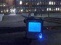
GPS in car meters away
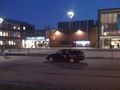
My car and entrance to Chalmers
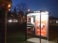
Hash in front of that tree


