Difference between revisions of "2011-12-29 42 -87"
imported>RocketMac (→Achievements) |
imported>Eldin m (clean up template and check categories.) |
||
| Line 1: | Line 1: | ||
| − | |||
| − | |||
| − | |||
| − | |||
| − | |||
| − | |||
| − | |||
| − | |||
| − | |||
{{meetup graticule | {{meetup graticule | ||
| lat=42 | | lat=42 | ||
| Line 14: | Line 5: | ||
}} | }} | ||
| − | |||
== Location == | == Location == | ||
| − | |||
An industrial park South of the airport. | An industrial park South of the airport. | ||
== Participants == | == Participants == | ||
| − | |||
* [[User:RocketMac|RocketMac]] | * [[User:RocketMac|RocketMac]] | ||
* [[User:Reschultzed|Reschultzed]] | * [[User:Reschultzed|Reschultzed]] | ||
== Plans == | == Plans == | ||
| − | |||
===Reschultzed=== | ===Reschultzed=== | ||
| Line 37: | Line 24: | ||
== Expedition == | == Expedition == | ||
| − | |||
===Reschultzed=== | ===Reschultzed=== | ||
| Line 53: | Line 39: | ||
<!-- | <!-- | ||
== Tracklog == | == Tracklog == | ||
| − | |||
<!-- RocketMac's log is available in [http://coldshadow.com/geohashing/2011-12-29.gpx GPX] and [http://coldshadow.com/geohashing/2011-12-29.kmz KMZ] formats --> | <!-- RocketMac's log is available in [http://coldshadow.com/geohashing/2011-12-29.gpx GPX] and [http://coldshadow.com/geohashing/2011-12-29.kmz KMZ] formats --> | ||
== Photos == | == Photos == | ||
| − | |||
| − | |||
| − | |||
===Reschultzed=== | ===Reschultzed=== | ||
| Line 80: | Line 62: | ||
== Achievements == | == Achievements == | ||
{{#vardefine:ribbonwidth|800px}} | {{#vardefine:ribbonwidth|800px}} | ||
| − | |||
===Reschultzed=== | ===Reschultzed=== | ||
{{land geohash | {{land geohash | ||
| Line 119: | Line 100: | ||
| − | |||
| − | |||
| − | |||
| − | |||
| − | |||
| − | |||
| − | |||
| − | |||
[[Category:Expeditions]] | [[Category:Expeditions]] | ||
[[Category:Expeditions with photos]] | [[Category:Expeditions with photos]] | ||
| − | |||
| − | |||
| − | |||
| − | |||
| − | |||
| − | |||
[[Category:Coordinates reached]] | [[Category:Coordinates reached]] | ||
| − | |||
| − | |||
| − | |||
| − | |||
| − | |||
| − | |||
| − | |||
| − | |||
| − | |||
| − | |||
| − | |||
Revision as of 15:45, 15 April 2013
| Thu 29 Dec 2011 in 42,-87: 42.9100365, -87.9207192 geohashing.info google osm bing/os kml crox |
Contents
Location
An industrial park South of the airport.
Participants
Plans
Reschultzed
My family and I went to the Wisconsin Dells for vacation this year. There was a geohash (2011-12-27 42 -87) which was fairly close (3.5 miles) to our route on Interstate 94. We tried to reach it on the way up, but it was over a mile away from any road. The hash point sat in what we assumed to be marshy swampland surrounding a stream. We decided not to seek it out further, because it was in a very large field of corn. After our stay, I decided to see if the geohash in the Madison graticule at my last opportunity for Wi-Fi, but it was not near the Dells. In fact, it was in the northwestern corner, and I live in the northwestern corner of the Kenoha graticule. Figuring it was a good idea to check the day's geohash for my home graticule, I found it really was worth it, as the geohash was less than one mile away from the Interstate, in a small industrial park. Unfortunately, my Garmin etrex, the only GPS I have that provides my current coordinates, is not working and has no batteries. My goal was to make it to the geohash and prove it (however possible).
RocketMac
Tonight is my wife's office holiday party and she has graciously excused me from having to go. Instead, I'll be on doggy duty, so I plan to swing home and grab the "kids" and drive on down.
Expedition
Reschultzed
We took I-894/I-43 to I-94, and got off at Exit 320. From Rawson Avenue, we turned on Sixth. At first, we drove too far south, and we had to turn around and travel up the road a bit. I got out and my dad took a picture of me very close to the spot. Since I had no GPS, I settled on a picture of the street sign at the nearest intersection (Sixth and Marquette). Hopefully, this should be enough to prove that I was, in fact, there...
RocketMac
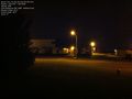
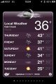
After work I punched everything into my GPS and off I went. Pretty straightforward. I got to the spot and took a few pictures, including one with an app that embeds the GPS data right on the picture. Sadly, I can't make it work for the front-facing camera nor could I get a decent pic reaching my finger around to the front. It was cold! Granted it was warmer that it should be this time of year, but still colder than I like.
My GPS app still doesn't update frequently enough, so I have to wander all around to get it to show that I was at the spot exactly. In this weather, I finally was inspired enough to write them and ask them to make that better. I already received a reply that it would be looked at, so that's cool!
On my way home, I stopped to check for nearby geocaches and found one close to where I stopped. A Scout Is... Brave is at a wonderful monument to our armed forces and those that have died. I was glad I checked.
Photos
Reschultzed
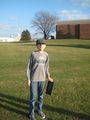
Reschultzed, with Stupid Grin™
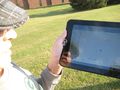
Reschultzed again, with the tablet
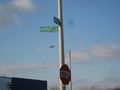
Reschultzed's only proof of visit


RocketMac

RocketMac's Stupid Grin
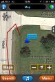
GPS reading
Camera of lit area with embedded GPS data
I'm not saying I was cold, but...
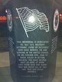
From the nearby geocache


Achievements
Reschultzed
Reschultzed earned the Land geohash achievement
|
Reschultzed earned the Drag-along achievement
|
RocketMac
RocketMac earned the Land geohash achievement
|
RocketMac earned the Hash collision honorable mention
|