Difference between revisions of "2012-01-06 50 8"
imported>QuarterCacher (An expedition message sent via Geohash Droid for Android.) |
imported>FippeBot m (Location) |
||
| (2 intermediate revisions by 2 users not shown) | |||
| Line 1: | Line 1: | ||
| − | |||
| − | |||
| − | |||
| − | |||
| − | |||
| − | |||
| − | |||
| − | |||
| − | |||
| − | |||
{{meetup graticule | {{meetup graticule | ||
| lat=50 | | lat=50 | ||
| Line 15: | Line 5: | ||
}} | }} | ||
| − | |||
__NOTOC__ | __NOTOC__ | ||
== Location == | == Location == | ||
| − | + | In the woods between Dombach, Riedelbach and Steinfischbach. | |
== Participants == | == Participants == | ||
| − | + | * [[User:QuarterCacher|QuarterCacher]] | |
| + | * [[User:Mampfred|Mampfred]] | ||
== Plans == | == Plans == | ||
| − | + | After a couple of weeks w/o hashing we both decided that it would be a good idea to do some friday-night hashing again. Looks like it's a 25 minute drive followed by ~ 2.5km walking to the hash. | |
== Expedition == | == Expedition == | ||
| − | + | We started off around 4:30 pm and got to a nearby parking lot when it was about to get dark. The usual after-work hashing situation really :) | |
| + | |||
| + | Thanks to Open Streetmaps on our GPS devices we quickly located the shortest path to the hash and started walking. Nothing exciting on the way, we found the hash 50 meters into the woods, took some photos and headed back. | ||
| + | |||
| + | A nice friday-night walk really, not too cold, about 5 km in total. Amazing what you regard as being a fun friday night out when you get older ;) | ||
| + | |||
| + | Fun fact: This hash did not follow my general rule that for hashing in our area you always have to climb a hill. Looking at the track log the hash was near the bottom of a river valley and for a change we had to climb the hill on the way back (which QuarterCacher let me know quite noisily during the climb ;). | ||
== Tracklog == | == Tracklog == | ||
| − | + | See [http://www.everytrail.com/view_trip.php?trip_id=1409367 here]. | |
== Photos == | == Photos == | ||
| − | |||
| − | |||
| − | |||
<gallery perrow="5"> | <gallery perrow="5"> | ||
| + | Image:2012-01-06_50_8_parking.jpg | Parking in the near dark | ||
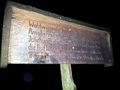
| + | Image:2012-01-06_50_8_coordinates.jpg | Coordinates ... | ||
| + | Image:2012-01-06_50_8_reached.jpg |... reached. | ||
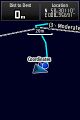
| + | Image:2012-01-06_50_8_map.jpg | ||
| + | Image:2012-01-06_50_8_17-49-47-725.jpg | Live grin | ||
| + | Image:2012-01-06_50_8_grin.jpg | And a sharper grin | ||
| + | Image:2012-01-06_50_8_Waldwiesental_Rossbach.jpg | Apparently we were wandering the Waldwiesental Rossbach | ||
</gallery> | </gallery> | ||
== Achievements == | == Achievements == | ||
{{#vardefine:ribbonwidth|800px}} | {{#vardefine:ribbonwidth|800px}} | ||
| − | + | * Land | |
| − | |||
| − | |||
| − | |||
| − | |||
| − | |||
| − | |||
| − | |||
| − | |||
| − | |||
| − | |||
| − | |||
[[Category:Expeditions]] | [[Category:Expeditions]] | ||
| − | |||
[[Category:Expeditions with photos]] | [[Category:Expeditions with photos]] | ||
| − | |||
| − | |||
| − | |||
| − | |||
| − | |||
[[Category:Coordinates reached]] | [[Category:Coordinates reached]] | ||
| − | + | {{location|DE|HE|HG}} | |
| − | |||
| − | |||
| − | |||
| − | |||
| − | |||
| − | |||
| − | |||
| − | |||
| − | |||
Latest revision as of 01:58, 13 August 2019
| Fri 6 Jan 2012 in 50,8: 50.3011014, 8.3569190 geohashing.info google osm bing/os kml crox |
Location
In the woods between Dombach, Riedelbach and Steinfischbach.
Participants
Plans
After a couple of weeks w/o hashing we both decided that it would be a good idea to do some friday-night hashing again. Looks like it's a 25 minute drive followed by ~ 2.5km walking to the hash.
Expedition
We started off around 4:30 pm and got to a nearby parking lot when it was about to get dark. The usual after-work hashing situation really :)
Thanks to Open Streetmaps on our GPS devices we quickly located the shortest path to the hash and started walking. Nothing exciting on the way, we found the hash 50 meters into the woods, took some photos and headed back.
A nice friday-night walk really, not too cold, about 5 km in total. Amazing what you regard as being a fun friday night out when you get older ;)
Fun fact: This hash did not follow my general rule that for hashing in our area you always have to climb a hill. Looking at the track log the hash was near the bottom of a river valley and for a change we had to climb the hill on the way back (which QuarterCacher let me know quite noisily during the climb ;).
Tracklog
See here.
Photos
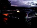
Parking in the near dark
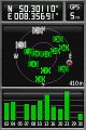
Coordinates ...

... reached.
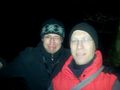
Live grin
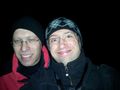
And a sharper grin
Apparently we were wandering the Waldwiesental Rossbach


Achievements
- Land