Difference between revisions of "2012-01-11 48 9"
imported>Steingesicht (→Expedition) |
imported>FippeBot m (Location) |
||
| (4 intermediate revisions by 2 users not shown) | |||
| Line 1: | Line 1: | ||
| − | |||
<!-- If you did not specify these parameters in the template, please substitute appropriate values for IMAGE, LAT, LON, and DATE (YYYY-MM-DD format) | <!-- If you did not specify these parameters in the template, please substitute appropriate values for IMAGE, LAT, LON, and DATE (YYYY-MM-DD format) | ||
| Line 15: | Line 14: | ||
}} | }} | ||
| − | + | ||
__NOTOC__ | __NOTOC__ | ||
== Location == | == Location == | ||
| − | + | ||
An open space with a paved ground between the Bahnhofstrasse and the Aich creek in Waldenbuch. Surrounded by some pittoresk non-residential buildings. | An open space with a paved ground between the Bahnhofstrasse and the Aich creek in Waldenbuch. Surrounded by some pittoresk non-residential buildings. | ||
Some interesting facts about the location: | Some interesting facts about the location: | ||
| + | |||
The Bahnhofstrasse (engl. Train Station Road) is build at the old railway track from [http://www.vergessene-bahnen.de/Ex318a_1.htm Leinfelden to Waldenbuch]. The railroad line was in service from 1928 to 1956. The tracks where removed until 1972. Today You can walk or bike on the old railroad bed. The last kilometer of the old track is the Bahnhofstrasse in Waldenbuch - but without a train station. | The Bahnhofstrasse (engl. Train Station Road) is build at the old railway track from [http://www.vergessene-bahnen.de/Ex318a_1.htm Leinfelden to Waldenbuch]. The railroad line was in service from 1928 to 1956. The tracks where removed until 1972. Today You can walk or bike on the old railroad bed. The last kilometer of the old track is the Bahnhofstrasse in Waldenbuch - but without a train station. | ||
| Line 27: | Line 27: | ||
== Participants == | == Participants == | ||
| − | + | ||
| − | [[User:Steingesicht|Steingesicht]] was there at exact 17.00 local time | + | * [[User:Steingesicht|Steingesicht]] was there at exact 17.00 local time |
== Plans == | == Plans == | ||
| − | + | ||
The expedition was done as planned. | The expedition was done as planned. | ||
== Expedition == | == Expedition == | ||
| − | + | ||
There was nothing special in this expedition, so I added some facts about the location above. | There was nothing special in this expedition, so I added some facts about the location above. | ||
| Line 42: | Line 42: | ||
All things considered, it was a nice after work walk with fresh air. | All things considered, it was a nice after work walk with fresh air. | ||
| − | --[[User:Steingesicht|Steingesicht]] 17:17, 11 January 2012 (EST) | + | --[[User:Steingesicht|Steingesicht]] 17:17, 11 January 2012 (EST) |
| + | |||
| − | |||
| − | |||
| − | |||
== Photos == | == Photos == | ||
| − | + | ||
| − | |||
| − | |||
<gallery perrow="5"> | <gallery perrow="5"> | ||
| + | Image:2012 01 11 48 9 hash point-1.jpeg | proof | ||
| + | Image:2012 01 11 48 9 hash point-2.jpeg | the hashpoint | ||
| + | Image:2012 01 11 48 9 view to hash point.jpeg | view from the street | ||
| + | Image:2012 01 11 48 9 christmas tree.jpeg | someone left chrismas trees near the hash point | ||
| + | Image:2012 01 11 48 9 Bahnhofstrasse-1.jpeg | Bahnhofstrasse | ||
| + | Image:2012 01 11 48 9 Bahnhofstrasse-2.jpeg | Bahnhofstrasse | ||
| + | Image:2012 01 11 48 9 Aich river-1.jpeg | river Aich | ||
| + | Image:2012 01 11 48 9 Aich river-2.jpeg | river Aich | ||
</gallery> | </gallery> | ||
| Line 58: | Line 62: | ||
{{#vardefine:ribbonwidth|800px}} | {{#vardefine:ribbonwidth|800px}} | ||
<!-- Add any achievement ribbons you earned below, or remove this section --> | <!-- Add any achievement ribbons you earned below, or remove this section --> | ||
| − | |||
| − | |||
| − | |||
| − | + | {{land geohash | latitude = 48 | longitude = 9 | date = 2012-01-11 | name = Steingesicht}} | |
| − | |||
| Line 69: | Line 69: | ||
[[Category:Coordinates reached]] | [[Category:Coordinates reached]] | ||
[[Category:Expeditions with photos]] | [[Category:Expeditions with photos]] | ||
| − | + | {{location|DE|BW|BB}} | |
| − | |||
| − | |||
| − | |||
| − | |||
| − | |||
| − | |||
| − | |||
| − | |||
Latest revision as of 02:01, 13 August 2019
| Wed 11 Jan 2012 in 48,9: 48.6358341, 9.1434326 geohashing.info google osm bing/os kml crox |
Location
An open space with a paved ground between the Bahnhofstrasse and the Aich creek in Waldenbuch. Surrounded by some pittoresk non-residential buildings.
Some interesting facts about the location:
The Bahnhofstrasse (engl. Train Station Road) is build at the old railway track from Leinfelden to Waldenbuch. The railroad line was in service from 1928 to 1956. The tracks where removed until 1972. Today You can walk or bike on the old railroad bed. The last kilometer of the old track is the Bahnhofstrasse in Waldenbuch - but without a train station.
The small river Aich is almost 30km long and goes from the Schönbuch forest to the river Neckar. It is mostly surrounded by an very lovely nature.
Participants
- Steingesicht was there at exact 17.00 local time
Plans
The expedition was done as planned.
Expedition
There was nothing special in this expedition, so I added some facts about the location above.
I went by car to a parking lot at the nearby supermarket. Then visited the hash point and walked around a little. After that i did a little walk to a close geocache GCP6HK.
All things considered, it was a nice after work walk with fresh air. --Steingesicht 17:17, 11 January 2012 (EST)
Photos
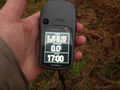
proof
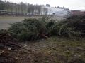
the hashpoint
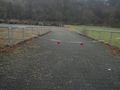
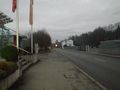
view from the street
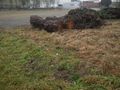
someone left chrismas trees near the hash point
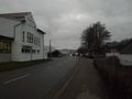
Bahnhofstrasse
Bahnhofstrasse
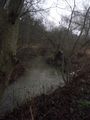
river Aich
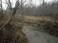
river Aich


Achievements
Steingesicht earned the Land geohash achievement
|