Difference between revisions of "2012-01-11 51 -1"
imported>Randomguy3 (Created page with "{{subst:Expedition |lat = 51 |lon = -1 |date = 2012-01-11 }} {{meetup graticule | lat=51 | lon=-1 | date=2012-01-11 | graticule_name=Swindon | graticule_link=Swindon, United Kin...") |
imported>FippeBot m (Location) |
||
| (3 intermediate revisions by 3 users not shown) | |||
| Line 1: | Line 1: | ||
| − | |||
| − | |||
| − | |||
| − | |||
| − | |||
| − | |||
| − | |||
| − | |||
| − | |||
| − | |||
| − | |||
| − | |||
| − | |||
| − | |||
| − | |||
| − | |||
| − | |||
| − | |||
| − | |||
| − | |||
| − | |||
| − | |||
| − | |||
| − | |||
| − | |||
| − | |||
| − | |||
| − | |||
| − | |||
| − | |||
| − | |||
| − | |||
| − | |||
| − | |||
| − | |||
| − | |||
| − | |||
| − | |||
| − | |||
| − | |||
| − | |||
| − | |||
| − | |||
| − | |||
| − | |||
| − | |||
| − | |||
| − | |||
| − | |||
| − | |||
| − | |||
| − | |||
| − | |||
| − | |||
| − | |||
| − | |||
| − | |||
| − | |||
| − | |||
| − | |||
| − | |||
| − | |||
| − | |||
| − | |||
| − | |||
| − | |||
| − | |||
| − | |||
| − | |||
| − | |||
| − | |||
| − | |||
| − | |||
| − | |||
| − | |||
| − | |||
{{meetup graticule | {{meetup graticule | ||
| lat=51 | | lat=51 | ||
| Line 91: | Line 15: | ||
* [[User:Randomguy3|Alex]] | * [[User:Randomguy3|Alex]] | ||
| − | * Joe | + | * [[User:jophish|Joe]] |
== Expedition == | == Expedition == | ||
| Line 113: | Line 37: | ||
</gallery> | </gallery> | ||
| + | == Achievements == | ||
| + | |||
| + | * Land Geohash | ||
| + | * Bike Geohash? | ||
| + | * Drag-along? | ||
| + | |||
| + | |||
| + | [[Category:Expeditions]] | ||
[[Category:Expeditions with photos]] | [[Category:Expeditions with photos]] | ||
[[Category:Coordinates reached]] | [[Category:Coordinates reached]] | ||
| + | {{location|GB|ENG|OXF}} | ||
Latest revision as of 02:01, 13 August 2019
| Wed 11 Jan 2012 in Swindon: 51.6358341, -1.1434326 geohashing.info google osm bing/os kml crox |
Location
A field in Shillingford, about 16 km south of Oxford.
Participants
Expedition
Since Shillingford isn't too far from Oxford, where Joe goes to University, he decided that it would be nice to cycle to the location. The only person he managed to recruit was Alex, who suggested aiming to have lunch at the site.
The cycle there was largely uneventful, although most of the road wasn't very nice to cycle along. Reaching the right part of the field was straightforward, if a little muddy. We decided that it would be better to find somewhere nearby for lunch, rather than trying to eat it in the middle of a muddy field.
Having eaten lunch, we decided that it would be nicer to cycle back along the river Thames (possibly taking a shortcut to avoid the Abingdon loop). With this in mind, we headed across the main road, looking for the bridleway and/or towpath. This turned out to be trickier than we thought. We found *a* bridleway, but it just sent us around in a loop. A rather muddy loop. That ended with Alex getting a flat tyre.
Having failed to get hold of anyone with motorised transport, they resolved to try to catch a bus (and trust to the kindness of the driver to let them bring their bikes on board). They found a stop on the A4047 going in the right direction, but failed to flag down the first bus successfully. The second (half an hour later) stopped for them, though, and they made it back to Oxford in one piece.
Of course, Alex then had a half-hour trek home with a flat tyre, trying to keep the weight off the back wheel...
Photos
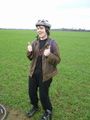
Joe
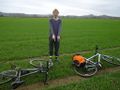
Alex
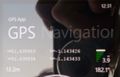
GPS


Achievements
- Land Geohash
- Bike Geohash?
- Drag-along?