Difference between revisions of "2012-01-13 58 15"
imported>Cjk ([live picture] Me and hot snakes [http://www.openstreetmap.org/?lat=58.92618004&lon=15.83823049&zoom=16&layers=B000FTF @58.9262,15.8382]) |
imported>FippeBot m (Location) |
||
| (21 intermediate revisions by 4 users not shown) | |||
| Line 1: | Line 1: | ||
| + | [[Image:{{{image|2012-01-13_58_15_00-52-42-207.jpg}}}|thumb|left]] | ||
| − | |||
| − | |||
| − | |||
| − | |||
| − | |||
| − | |||
| − | |||
| − | |||
{{meetup graticule | {{meetup graticule | ||
| lat=58 | | lat=58 | ||
| Line 15: | Line 8: | ||
}} | }} | ||
| − | + | ||
__NOTOC__ | __NOTOC__ | ||
== Location == | == Location == | ||
| − | + | ||
| + | In the woods near a lake fairly close to a logging road. | ||
== Participants == | == Participants == | ||
| − | + | ||
| + | * [[User:Cjk|Carl-Johan]] | ||
== Plans == | == Plans == | ||
| − | + | ||
| + | To continue from [[2012-01-13 58 16]] to this one and then onward to [[2012-01-13 59 15]]. | ||
| + | The westward drive was going to be on small roads towards Katrineholm. | ||
| + | |||
| + | I reached these 4 of my planned graticules. | ||
| + | |||
| + | *[[2012-01-13 58 17]] | ||
| + | *[[2012-01-13 58 16]] | ||
| + | *[[2012-01-13 58 15]] | ||
| + | *[[2012-01-13 59 15]] | ||
== Expedition == | == Expedition == | ||
| − | |||
| + | Turned back on 53 and drove 2 km to the road I was going to take. It was a fairly dodgy gravel road. And now came the Class 1 blizzard that SMHI (Swedish Meteorological and Hydrological Institute) had warned about. But I have good studded tires so onwards. Then onto a bigger road to Katrineholm and onto the small road leading round Tisnaren, the lake. | ||
| − | *At the hash -- [[User:Cjk| | + | This was very very winding, and for the first time I lost grip in my front tires in a very slow corner and started understeering a bit. Nothing serious though. That corner was very close to the lake, like 20 meters and the humid air had frozen over on the road surface. Found the logging road and turned into the woods. Reached the end of the line and started walking. |
| − | + | ||
| − | + | The sky was just all gray so my internal compass wasn't perfect. Therefore it was hard trying to find the perfect line towards the geohash. But up a tiny hill and I found it. | |
| + | |||
| + | Took some pictures and made a nice xkcd with sticks. The loggers had sawed off tons of pine branches while thinning out the forest so there was ample a branch to choose from. | ||
| + | |||
| + | Headed back to car and ate some chocolate and soldiered on toward [[2012-01-13 59 15]]. | ||
| + | |||
| + | *At the hash -- [[User:Cjk|Carl-Johan]] [http://www.openstreetmap.org/?lat=58.92615716&lon=15.83824399&zoom=16&layers=B000FTF @58.9262,15.8382] 08:32, 13 January 2012 (EST) | ||
== Photos == | == Photos == | ||
| − | + | ||
| − | |||
| − | |||
<gallery perrow="5"> | <gallery perrow="5"> | ||
| + | Image:2012-01-13_59_15_00-33-34-114.jpg | Blizzard | ||
| + | Image:2012-01-13_58_15_00-35-23-006.jpg | More blizzard | ||
| + | Image:2012-01-13_58_15_00-36-02-587.jpg | End of line | ||
| + | Image:2012-01-13_58_15_00-36-48-066.jpg | Logging tracks | ||
Image:2012-01-13_58_15_14-36-32-865.jpg | Me and hot snakes [http://www.openstreetmap.org/?lat=58.92618004&lon=15.83823049&zoom=16&layers=B000FTF @58.9262,15.8382] | Image:2012-01-13_58_15_14-36-32-865.jpg | Me and hot snakes [http://www.openstreetmap.org/?lat=58.92618004&lon=15.83823049&zoom=16&layers=B000FTF @58.9262,15.8382] | ||
| + | Image:2012-01-13_58_15_14-37-00-013.jpg | Me and hash [http://www.openstreetmap.org/?lat=58.92615443&lon=15.83834164&zoom=16&layers=B000FTF @58.9262,15.8383] | ||
| + | Image:2012-01-13_58_15_14-37-32-384.jpg | Emptiness [http://www.openstreetmap.org/?lat=58.92615736&lon=15.83838891&zoom=16&layers=B000FTF @58.9262,15.8384] | ||
| + | Image:2012-01-13_58_15_14-37-54-583.jpg | Marker [http://www.openstreetmap.org/?lat=58.92617618&lon=15.83832622&zoom=16&layers=B000FTF @58.9262,15.8383] | ||
| + | Image:2012-01-13_58_15_00-37-58-998.jpg | The spot | ||
| + | Image:2012-01-13_58_15_00-52-42-207.jpg | | ||
</gallery> | </gallery> | ||
== Achievements == | == Achievements == | ||
{{#vardefine:ribbonwidth|800px}} | {{#vardefine:ribbonwidth|800px}} | ||
| − | |||
| − | |||
| − | |||
| − | |||
| − | |||
| − | |||
| − | + | {{land geohash | latitude = 58 | longitude = 15 | date = 2012-01-13 | name = Carl-Johan | image = 2012-01-13_58_15_14-37-00-013.jpg }} | |
| − | + | {{Frozen Geohash | latitude = 58 | longitude = 15 | date = 2012-01-13 | | name = Carl-Johan | image = 2012-01-13_58_15_00-36-48-066.jpg }} | |
| − | + | {{Minesweeper geohash | graticule = Norrköping, Sweden | ranknumber = 4 | w = true | ne = true | e = true | nw = true| name = Carl-Johan }} | |
| − | -- | + | {{Multihash2 | count = 4 | date = 2012-01-13 | name = Carl-Johan | }} |
| + | {{police geohash | latitude = 58 | longitude = 16 | date = 2012-01-13 | encounter = riding behind cop car on freeway | name = Carl-Johan | image = 2012-01-13_58_16_02-56-13-803.jpg }} | ||
| − | |||
[[Category:Expeditions]] | [[Category:Expeditions]] | ||
| − | |||
[[Category:Expeditions with photos]] | [[Category:Expeditions with photos]] | ||
| − | + | ||
| − | |||
| − | |||
| − | |||
| − | |||
[[Category:Coordinates reached]] | [[Category:Coordinates reached]] | ||
| − | + | {{location|SE|E}} | |
| − | |||
| − | |||
| − | |||
| − | |||
| − | |||
| − | |||
| − | |||
| − | |||
| − | |||
Latest revision as of 02:03, 13 August 2019

| Fri 13 Jan 2012 in 58,15: 58.9261262, 15.8381610 geohashing.info google osm bing/os kml crox |
Location
In the woods near a lake fairly close to a logging road.
Participants
Plans
To continue from 2012-01-13 58 16 to this one and then onward to 2012-01-13 59 15. The westward drive was going to be on small roads towards Katrineholm.
I reached these 4 of my planned graticules.
Expedition
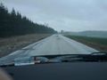
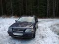
Turned back on 53 and drove 2 km to the road I was going to take. It was a fairly dodgy gravel road. And now came the Class 1 blizzard that SMHI (Swedish Meteorological and Hydrological Institute) had warned about. But I have good studded tires so onwards. Then onto a bigger road to Katrineholm and onto the small road leading round Tisnaren, the lake.
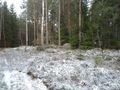
This was very very winding, and for the first time I lost grip in my front tires in a very slow corner and started understeering a bit. Nothing serious though. That corner was very close to the lake, like 20 meters and the humid air had frozen over on the road surface. Found the logging road and turned into the woods. Reached the end of the line and started walking.
The sky was just all gray so my internal compass wasn't perfect. Therefore it was hard trying to find the perfect line towards the geohash. But up a tiny hill and I found it.
Took some pictures and made a nice xkcd with sticks. The loggers had sawed off tons of pine branches while thinning out the forest so there was ample a branch to choose from.
Headed back to car and ate some chocolate and soldiered on toward 2012-01-13 59 15.
- At the hash -- Carl-Johan @58.9262,15.8382 08:32, 13 January 2012 (EST)
Photos

Blizzard
More blizzard
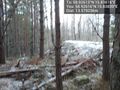
End of line
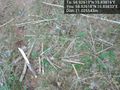
Logging tracks
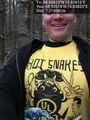
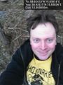
Me and hot snakes @58.9262,15.8382
Me and hash @58.9262,15.8383
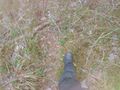
Emptiness @58.9262,15.8384
Marker @58.9262,15.8383
The spot


Achievements
Carl-Johan earned the Land geohash achievement
|

Carl-Johan achieved level 4 of the Minesweeper Geohash achievement
|
Carl-Johan earned the Multihash Achievement
|
Carl-Johan earned the Police Geohash Achievement
|