Difference between revisions of "2012-01-13 58 16"
imported>Cjk ([live picture] Sköt [http://www.openstreetmap.org/?lat=58.92609211&lon=16.83818433&zoom=16&layers=B000FTF @58.9261,16.8382]) |
m (per Renaming Proposal) |
||
| (31 intermediate revisions by 4 users not shown) | |||
| Line 1: | Line 1: | ||
| + | [[Image:{{{image|2012-01-13_58_16_13-27-31-498.jpg}}}|thumb|left]] | ||
| − | |||
| − | |||
| − | |||
| − | |||
| − | |||
| − | |||
| − | |||
| − | |||
{{meetup graticule | {{meetup graticule | ||
| lat=58 | | lat=58 | ||
| Line 19: | Line 12: | ||
== Location == | == Location == | ||
<!-- where you've surveyed the hash to be --> | <!-- where you've surveyed the hash to be --> | ||
| + | In a frozen field north of Nyköping. | ||
== Participants == | == Participants == | ||
<!-- who attended --> | <!-- who attended --> | ||
| + | [[User:Cjk|Carl-Johan]] | ||
== Plans == | == Plans == | ||
<!-- what were the original plans --> | <!-- what were the original plans --> | ||
| + | To continue the multihash from [[2012-01-13 58 17]] and then speed on to [[2012-01-13 58 15]]. Also to get the Virgin Graticule of Norrköping, Sweden! | ||
| + | |||
| + | I reached these 4 of my planned graticules. | ||
| + | |||
| + | *[[2012-01-13 58 17]] | ||
| + | *[[2012-01-13 58 16]] | ||
| + | *[[2012-01-13 58 15]] | ||
| + | *[[2012-01-13 59 15]] | ||
== Expedition == | == Expedition == | ||
<!-- how it all turned out. your narrative goes here. --> | <!-- how it all turned out. your narrative goes here. --> | ||
| + | From Nynäshamn I hade to do a Russian И up to Södertälje because of the Baltic preventing any travel by anything by boat West of Nynäshamn. The first road, 225 I think, is very twisty and it started to snow a bit as well. Then on the E4 down to Nyköping. Caught up with a police car, wonder if I can get an achievement for that? Then north onto the 53. Passed the hash and found a place to park. Right on the road was a piece of metal from a tractor or something like that. Picked it up and walked toward the hash. Also found a mudflap from a truck. That'll be my makeshift marker. | ||
| − | + | The field had been waterlogged and this had of course frozen over. The ice was thick enough so it didn't break when I walked on it. Marked the spot with my loot and took some pictures and a panorama. It started snowing again. Now due West to [[2012-01-13 58 15]]! | |
| − | |||
== Photos == | == Photos == | ||
| Line 38: | Line 41: | ||
<gallery perrow="5"> | <gallery perrow="5"> | ||
| − | Image:2012-01-13_58_16_13-26-42-082.jpg | | + | |
| + | |||
| + | Image:2012-01-13_58_16_22-56-46-467.jpg | Starting to snow | ||
| + | |||
| + | Image:2012-01-13_58_16_22-57-31-662.jpg | More snow on 225 | ||
| + | |||
| + | Image:2012-01-13_58_16_02-56-13-803.jpg | Cops | ||
| + | |||
| + | Image:2012-01-13_58_16_22-58-20-909.jpg | From car | ||
| + | |||
| + | Image:2012-01-13_58_16_23-00-36-447.jpg | Me at car | ||
| + | |||
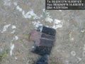
| + | Image:2012-01-13_58_16_23-01-53-977.jpg | Part of a tractor in middle of road. | ||
| + | |||
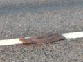
| + | Image:2012-01-13_58_16_13-26-42-082.jpg | Stuff marks the spot. [http://www.openstreetmap.org/?lat=58.92609211&lon=16.83818433&zoom=16&layers=B000FTF @58.9261,16.8382] | ||
| + | |||
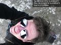
| + | Image:2012-01-13_58_16_13-27-31-498.jpg | Me and [https://www.youtube.com/watch?v=4_PK6550hFY OXES] [http://www.openstreetmap.org/?lat=58.92610016&lon=16.83815089&zoom=16&layers=B000FTF @58.9261,16.8382] | ||
| + | |||
| + | Image:2012-01-13_58_16_13-28-05-928.jpg | From above [http://www.openstreetmap.org/?lat=58.92609052&lon=16.83824393&zoom=16&layers=B000FTF @58.9261,16.8382] | ||
| + | |||
| + | Image:2012-01-13_58_16_23-02-56-297.jpg | Panorama 1 | ||
| + | |||
| + | Image:2012-01-13_58_16_23-03-51-568.jpg | Panorama 2 | ||
| + | |||
| + | Image:2012-01-13_58_16_23-04-39-743.jpg | Spot | ||
| + | |||
| + | Image:2012-01-13_58_16_23-05-26-376.jpg | Different angle, note ice | ||
| + | |||
| + | Image:2012-01-13_58_16_23-06-03-148.jpg | Car | ||
</gallery> | </gallery> | ||
| Line 44: | Line 75: | ||
{{#vardefine:ribbonwidth|800px}} | {{#vardefine:ribbonwidth|800px}} | ||
<!-- Add any achievement ribbons you earned below, or remove this section --> | <!-- Add any achievement ribbons you earned below, or remove this section --> | ||
| + | {{land geohash | latitude = 58 | longitude = 16 | date = 2012-01-13 | name = Carl-Johan | image = 2012-01-13_58_16_13-28-05-928.jpg }} | ||
| + | {{Frozen Geohash | latitude = 58 | longitude = 16 | date = 2012-01-13 | | name = Carl-Johan | image = 2012-01-13_58_16_23-04-39-743.jpg }} | ||
| + | {{Minesweeper geohash | graticule = Norrköping, Sweden | ranknumber = 4 | w = true | ne = true | e = true | nw = true| name = Carl-Johan }} | ||
| + | {{Multihash2 | count = 4 | date = 2012-01-13 | name = Carl-Johan | }} | ||
| + | {{police geohash | latitude = 58 | longitude = 16 | date = 2012-01-13 | encounter = riding behind cop car on freeway | name = Carl-Johan | image = 2012-01-13_58_16_02-56-13-803.jpg }} | ||
| + | {{Graticule unlocked | latitude = 58 | longitude = 16 | date = 2012-01-13 | name = [[User:Cjk|Carl-Johan]] | image = 2012-01-13_58_16_13-27-31-498.jpg }} | ||
| − | |||
| − | |||
| − | |||
| − | |||
| − | |||
| − | |||
| − | |||
| − | |||
| − | |||
| − | |||
| − | |||
[[Category:Expeditions]] | [[Category:Expeditions]] | ||
| − | |||
[[Category:Expeditions with photos]] | [[Category:Expeditions with photos]] | ||
| − | |||
| − | |||
| − | |||
| − | |||
| − | |||
[[Category:Coordinates reached]] | [[Category:Coordinates reached]] | ||
| − | + | {{location|SE|D}} | |
| − | |||
| − | |||
| − | |||
| − | |||
| − | |||
| − | |||
| − | |||
| − | |||
| − | |||
Latest revision as of 05:47, 20 March 2024

| Fri 13 Jan 2012 in 58,16: 58.9261262, 16.8381610 geohashing.info google osm bing/os kml crox |
Location
In a frozen field north of Nyköping.
Participants
Plans
To continue the multihash from 2012-01-13 58 17 and then speed on to 2012-01-13 58 15. Also to get the Virgin Graticule of Norrköping, Sweden!
I reached these 4 of my planned graticules.
Expedition
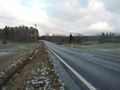
From Nynäshamn I hade to do a Russian И up to Södertälje because of the Baltic preventing any travel by anything by boat West of Nynäshamn. The first road, 225 I think, is very twisty and it started to snow a bit as well. Then on the E4 down to Nyköping. Caught up with a police car, wonder if I can get an achievement for that? Then north onto the 53. Passed the hash and found a place to park. Right on the road was a piece of metal from a tractor or something like that. Picked it up and walked toward the hash. Also found a mudflap from a truck. That'll be my makeshift marker.
The field had been waterlogged and this had of course frozen over. The ice was thick enough so it didn't break when I walked on it. Marked the spot with my loot and took some pictures and a panorama. It started snowing again. Now due West to 2012-01-13 58 15!
Photos
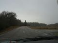
Starting to snow
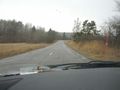
More snow on 225
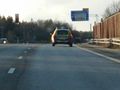
Cops
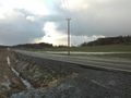
From car

Me at car
Part of a tractor in middle of road.
Stuff marks the spot. @58.9261,16.8382

Me and OXES @58.9261,16.8382
From above @58.9261,16.8382
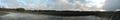
Panorama 1
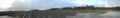
Panorama 2
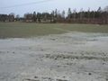
Spot
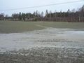
Different angle, note ice
Car


Achievements
Carl-Johan earned the Land geohash achievement
|

Carl-Johan achieved level 4 of the Minesweeper Geohash achievement
|
Carl-Johan earned the Multihash Achievement
|
Carl-Johan earned the Police Geohash Achievement
|
Carl-Johan earned the Graticule Unlocked Achievement
|