Difference between revisions of "2012-01-14 49 7"
imported>Ekorren (template only by now, more to be added later) |
imported>FippeBot m (Location) |
||
| (3 intermediate revisions by one other user not shown) | |||
| Line 1: | Line 1: | ||
{{meetup graticule | {{meetup graticule | ||
| − | | lat= | + | | lat=49 |
| − | | lon= | + | | lon=7 |
| date=2012-01-14 | | date=2012-01-14 | ||
}} | }} | ||
| Line 7: | Line 7: | ||
== Location == | == Location == | ||
| − | A field | + | A field near the hamlet of ''Schernau'', which belongs to ''Martinshöhe''. |
== Participants == | == Participants == | ||
| Line 19: | Line 19: | ||
== Gallery == | == Gallery == | ||
| − | |||
<gallery> | <gallery> | ||
| + | File:2012-01-14_49_7_train.JPG|The train to Bruchmühlbach-Miesau | ||
| + | File:2012-01-14_49_7_road_up.JPG|This way up | ||
| + | File:2012-01-14_49_7_direction_up.JPG | ||
| + | File:2012-01-14_49_7_Schernau_sign.JPG|Reaching Schernau, a hamlet that's now an old people's home and provides access to the hash. | ||
| + | File:2012-01-14_49_7_phonebox_1.JPG|A phonebox that's at least 35 years old - probably much older. They are extremely rare now. | ||
| + | File:2012-01-14_49_7_phonebox_2.JPG | ||
| + | File:2012-01-14_49_7_phonebox_3.JPG|The phone inside seems to be the only thing significantly newer... | ||
| + | File:2012-01-14_49_7_phonelist.JPG|... even this holder for a list of city codes is original... | ||
| + | File:2012-01-14_49_7_phonelist_closeup.JPG|... and the list? Is from before the GDR buy-out, listing Western Berlin only! | ||
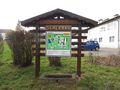
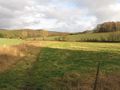
| + | File:2012-01-14_49_7_Hashfield.JPG|The hashfield | ||
| + | File:2012-01-14_49_7_GPS.JPG|Coordinates reached | ||
| + | File:2012-01-14_49_7_VFH_church.JPG|View from hash | ||
| + | File:2012-01-14_49_7_Schernau_panorama.JPG|View back to Schernau, with the hash somewhere behind the village | ||
| + | File:2012-01-14_49_7_Martinshoehe_church.JPG|Church of Martinshöhe | ||
| + | File:2012-01-14_49_7_Martin.JPG|Name patron | ||
| + | File:2012-01-14_49_7_windmills.JPG|Random impression along the way | ||
</gallery> | </gallery> | ||
| Line 27: | Line 42: | ||
[[Category:Expeditions with photos]] | [[Category:Expeditions with photos]] | ||
[[Category:Coordinates reached]] | [[Category:Coordinates reached]] | ||
| + | {{location|DE|RP|KL}} | ||
Latest revision as of 02:03, 13 August 2019
| Sat 14 Jan 2012 in 49,7: 49.3745879, 7.4805336 geohashing.info google osm bing/os kml crox |
Contents
Location
A field near the hamlet of Schernau, which belongs to Martinshöhe.
Participants
Expedition
Took a train from Heidelberg to Bruchmühlbach-Miesau, made my way up the hills to the hash and continued by bike to Homburg (Saar), from where I took a train back to Heidelberg.
Gallery
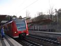
The train to Bruchmühlbach-Miesau
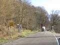
This way up
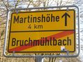
Reaching Schernau, a hamlet that's now an old people's home and provides access to the hash.
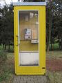
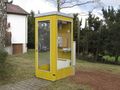
A phonebox that's at least 35 years old - probably much older. They are extremely rare now.
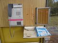
The phone inside seems to be the only thing significantly newer...
... even this holder for a list of city codes is original...
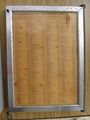
... and the list? Is from before the GDR buy-out, listing Western Berlin only!
The hashfield
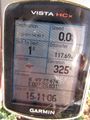
Coordinates reached
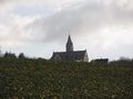
View from hash
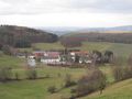
View back to Schernau, with the hash somewhere behind the village
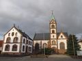
Church of Martinshöhe
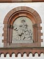
Name patron

Random impression along the way


