Difference between revisions of "2012-01-15 1 103"
imported>Cyazlars (Created page with "{{subst:Expedition |lat = 1 |lon = 103 |date = 2012-01-15 }}") |
imported>FippeBot m (Location) |
||
| (2 intermediate revisions by one other user not shown) | |||
| Line 1: | Line 1: | ||
| − | |||
| − | |||
| − | |||
| − | |||
| − | |||
| − | |||
| − | |||
| − | |||
| − | |||
| − | |||
{{meetup graticule | {{meetup graticule | ||
| lat=1 | | lat=1 | ||
| Line 15: | Line 5: | ||
}} | }} | ||
| − | |||
| − | |||
== Location == | == Location == | ||
| − | + | Open field along Jalan Timah, Pasir Gudang, Johor. | |
== Participants == | == Participants == | ||
| − | + | [[User:Cyazlars|Cyazlars]] + mum | |
== Plans == | == Plans == | ||
| − | + | We'll be leaving around 10am, crossing the Malaysian border and catching a bus to Pasir Gudang from JB Sentral/Larkin/wherever, really. At Pasir Gudang we're just going to wing it, as long as we get there. Possible routes include walking about an hour to the hashpoint or taking a cab. If there's a bus, all the better! And along the way pray hard that the open field isn't on private property... | |
== Expedition == | == Expedition == | ||
| − | + | My mum and I set out early in the morning around 10+ am, taking the bus AC7 all the way through Woodlands Checkpoint to the Johor CIQ complex. There we waited for bus service 224 that would take us to Pasir Gudang. Upon boarding the bus, I fell asleep and didn't wake up despite the driver's mad driving. We arrived at Pasir Gudang Bus Terminal around noon and decided to postpone walking to the hashpoint, instead walking around the local mall and having lunch first. It felt rather quiet for a Sunday. | |
| − | + | After lunch, we started walking to the hashpoint. It was looking rather promising until we reached the junction barely 50m away from the bus terminal. The very nicely paved sidewalk stopped abruptly and from then on there was absolutely no pedestrian walkway along the roads. We debated about the feasibility of walking on the grass alongside. Nope. So we turned back and got into a cab that took us all the way to the hashpoint. The elderly driver was a little puzzled about our destination, and even more puzzled still when he saw that it was simply an open field in the middle of the industrial district. My mum simply hand-waved it away by telling him it was one of my eccentricities. | |
| − | |||
| + | On the Google map it was hard to tell whether the area was fenced up or not, since the shadow that ran around the field could've been anything, really. I suspected that it was a fence, but when we reached the hashpoint I was immensely relieved to see that it was in fact an open football field. The dark shadow on the map was actually a really, really deep drain, the depth being almost equal to my height (1.54m). I carefully hopped over the drain and took pictures of the hashpoint. Border Geohash achieved! | ||
| + | |||
| + | On the way back we happened to board the same bus driven by the same driver. Mad driving all the way back, too... | ||
== Photos == | == Photos == | ||
| − | < | + | <gallery perrow="4"> |
| − | Image: | + | Image:2012_01_15_1_103_ciq.jpg | Waiting for the bus at JB Sentral |
| − | + | Image:2012_01_15_1_103_pgterminal.jpg | Pasir Gudang Bus Terminal | |
| − | + | Image:2012_01_15_1_103_pgterminal2.jpg | Before we tried to walk... | |
| + | Image:2012_01_15_1_103_taxi.jpg | Waiting taxi | ||
| + | Image:2012_01_15_1_103_hash1.jpg | Open field | ||
| + | Image:2012_01_15_1_103_hash2.jpg | Rickety bridge I didn't use | ||
| + | Image:2012_01_15_1_103_hash3.jpg | Shed | ||
| + | Image:2012_01_15_1_103_map.png| Map of hashpoint | ||
| + | Image:2012_01_15_1_103_me.jpg | Hashpoint reached! | ||
| + | Image:2012_01_15_1_103_time.jpg | Proof of date/time | ||
| + | Image:2012_01_15_1_103_passport.jpg | Proof of border crossing | ||
</gallery> | </gallery> | ||
== Achievements == | == Achievements == | ||
| − | {{ | + | {{Border geohash achievement |
| − | + | | latitude = 1 | |
| + | | longitude = 103 | ||
| + | | date = 2012-01-15 | ||
| + | | country1 = Singapore | ||
| + | | country2 = Malaysia | ||
| + | | name = Cyazlars | ||
| + | }} | ||
| − | + | [[Category:Coordinates reached]] | |
| − | |||
| − | |||
| − | [[Category: | ||
| − | |||
| − | |||
| − | |||
| − | |||
| − | |||
| − | |||
| − | |||
[[Category:Expeditions]] | [[Category:Expeditions]] | ||
| − | |||
[[Category:Expeditions with photos]] | [[Category:Expeditions with photos]] | ||
| − | |||
[[Category:Expedition without GPS]] | [[Category:Expedition without GPS]] | ||
| − | + | {{location|MY|01}} | |
| − | |||
| − | |||
| − | |||
| − | |||
| − | |||
| − | |||
| − | |||
| − | |||
| − | |||
| − | |||
| − | |||
| − | |||
| − | |||
Latest revision as of 02:04, 13 August 2019
| Sun 15 Jan 2012 in 1,103: 1.4493384, 103.9166824 geohashing.info google osm bing/os kml crox |
Location
Open field along Jalan Timah, Pasir Gudang, Johor.
Participants
Cyazlars + mum
Plans
We'll be leaving around 10am, crossing the Malaysian border and catching a bus to Pasir Gudang from JB Sentral/Larkin/wherever, really. At Pasir Gudang we're just going to wing it, as long as we get there. Possible routes include walking about an hour to the hashpoint or taking a cab. If there's a bus, all the better! And along the way pray hard that the open field isn't on private property...
Expedition
My mum and I set out early in the morning around 10+ am, taking the bus AC7 all the way through Woodlands Checkpoint to the Johor CIQ complex. There we waited for bus service 224 that would take us to Pasir Gudang. Upon boarding the bus, I fell asleep and didn't wake up despite the driver's mad driving. We arrived at Pasir Gudang Bus Terminal around noon and decided to postpone walking to the hashpoint, instead walking around the local mall and having lunch first. It felt rather quiet for a Sunday.
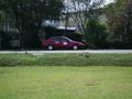
After lunch, we started walking to the hashpoint. It was looking rather promising until we reached the junction barely 50m away from the bus terminal. The very nicely paved sidewalk stopped abruptly and from then on there was absolutely no pedestrian walkway along the roads. We debated about the feasibility of walking on the grass alongside. Nope. So we turned back and got into a cab that took us all the way to the hashpoint. The elderly driver was a little puzzled about our destination, and even more puzzled still when he saw that it was simply an open field in the middle of the industrial district. My mum simply hand-waved it away by telling him it was one of my eccentricities.
On the Google map it was hard to tell whether the area was fenced up or not, since the shadow that ran around the field could've been anything, really. I suspected that it was a fence, but when we reached the hashpoint I was immensely relieved to see that it was in fact an open football field. The dark shadow on the map was actually a really, really deep drain, the depth being almost equal to my height (1.54m). I carefully hopped over the drain and took pictures of the hashpoint. Border Geohash achieved!
On the way back we happened to board the same bus driven by the same driver. Mad driving all the way back, too...
Photos
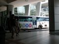
Waiting for the bus at JB Sentral
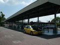
Pasir Gudang Bus Terminal
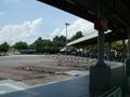
Before we tried to walk...
Waiting taxi
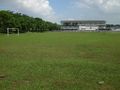
Open field
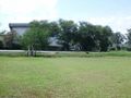
Rickety bridge I didn't use
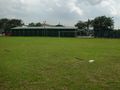
Shed
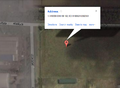
Map of hashpoint
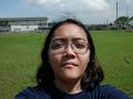
Hashpoint reached!
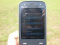
Proof of date/time
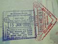
Proof of border crossing


Achievements
Cyazlars earned the Border geohash achievement
|