Difference between revisions of "2012-01-15 49 8"
imported>Jiml m (Fix result code) |
imported>Karl 77 (→Photos: Added 2 pictures) |
||
| Line 27: | Line 27: | ||
<gallery> | <gallery> | ||
| − | File:2012-01-16_49_8-electric_fence.jpg|This fence prevents wild animals leaving the woods. TdL dared to touch it and actually got a little shock | + | File:2012-01-15 49 8-cutout.JPG|View from the cutout on the Neckar |
| + | File:2012-01-16_49_8-electric_fence.jpg|This fence prevents wild animals leaving the woods. TdL dared to touch it and actually got a little shock | ||
File:2012-01-16_49_8-MNIMB.jpg|Mother nature is our bitch! | File:2012-01-16_49_8-MNIMB.jpg|Mother nature is our bitch! | ||
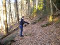
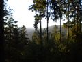
| + | File:2012-01-15_49_8_Hill.JPG|This is where we went up | ||
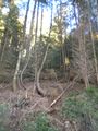
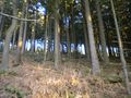
File:2012-01-16_49_8-Hashpoint_1.jpg|View to the hashpoint 1 | File:2012-01-16_49_8-Hashpoint_1.jpg|View to the hashpoint 1 | ||
File:2012-01-16_49_8-Hashpoint_2.jpg|View to the hashpoint 2 | File:2012-01-16_49_8-Hashpoint_2.jpg|View to the hashpoint 2 | ||
Revision as of 14:13, 27 January 2012
| Mon 16 Jan 2012 in 49,8: 49.7879038, 8.6086046 geohashing.info google osm bing/os kml crox |
Contents
Location
In the woods near Hirschhorn
Participants
and
Expedition
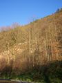
Karl_77 and TdL took the car to Hirschhorn as getting to the hash point with public transportation would have been too difficult. They parked at a little cutout near the hash point and decided to walk the remaining 200 m. It was very, very steep so they had to climb up the hill, which was pretty exhausting. It was a complex terrain featuring varoius difficult sections. Finally, Karl_77 and TdL reached the hashpoint which was in the middle of the woods on a hillside. The altitude difference from the parking place was about 120m. They took a few pictures and tried to get down before sunset. The way back was difficult as well but they found a little path and a nice shortcut over a meadow. It was a pretty exciting expedition which required some advanced climbing abilities. On the way back, the battery of Karl_77's mobile phone ran empty, so the Tracklog is incomplete.
Tracklog
http://www.everytrail.com/view_trip.php?trip_id=1420070
Photos
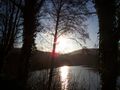
View from the cutout on the Neckar
This fence prevents wild animals leaving the woods. TdL dared to touch it and actually got a little shock
Mother nature is our bitch!
This is where we went up
View to the hashpoint 1
View to the hashpoint 2
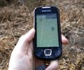
Coordinates reached

TdL's stupid grin at the hashpoint


