Difference between revisions of "2012-01-20 43 27"
From Geohashing
imported>Kisolre (→Participants) |
m |
||
| (3 intermediate revisions by 2 users not shown) | |||
| Line 1: | Line 1: | ||
| − | + | [[Image:2012-01-20_43_27_12-34-20-345.jpg|thumb|left]] | |
| − | |||
| − | |||
| − | |||
| − | |||
| − | |||
| − | |||
| − | |||
| − | |||
{{meetup graticule | {{meetup graticule | ||
| lat=43 | | lat=43 | ||
| Line 26: | Line 18: | ||
== Plans == | == Plans == | ||
<!-- what were the original plans --> | <!-- what were the original plans --> | ||
| + | Today I checked where is the nearest hash and since it was in the city and I had plans to go to some other places I decided to go visit :) | ||
== Expedition == | == Expedition == | ||
<!-- how it all turned out. your narrative goes here. --> | <!-- how it all turned out. your narrative goes here. --> | ||
| − | + | Nothing fancy. Just drove there, took some pictures and returned home. | |
| − | + | On the sat picture you see the courts but in reality they were covered with inflatable bubbles so to be usable in the winter. | |
| − | |||
| − | |||
| − | |||
== Photos == | == Photos == | ||
| Line 40: | Line 30: | ||
--> | --> | ||
<gallery perrow="5"> | <gallery perrow="5"> | ||
| − | |||
| − | |||
| − | |||
Image:2012-01-20_43_27_12-32-43-352.jpg | Geohash card. [http://www.openstreetmap.org/?lat=43.21270000&lon=27.94960000&zoom=16&layers=B000FTF @43.2127,27.9496] | Image:2012-01-20_43_27_12-32-43-352.jpg | Geohash card. [http://www.openstreetmap.org/?lat=43.21270000&lon=27.94960000&zoom=16&layers=B000FTF @43.2127,27.9496] | ||
| Line 55: | Line 42: | ||
</gallery> | </gallery> | ||
| − | |||
| − | |||
| − | |||
| − | |||
| − | |||
| − | |||
| − | |||
| − | |||
| − | |||
| − | |||
| − | |||
| − | |||
| − | |||
| − | |||
| − | |||
[[Category:Expeditions]] | [[Category:Expeditions]] | ||
| − | + | [[Category:Expeditions with photos]] | |
| − | [[Category:Expeditions with photos]] | ||
| − | |||
| − | |||
| − | |||
| − | |||
| − | |||
[[Category:Coordinates reached]] | [[Category:Coordinates reached]] | ||
| − | + | {{location|BG|B}} | |
| − | |||
| − | |||
| − | |||
| − | |||
| − | |||
| − | |||
| − | |||
| − | |||
| − | |||
Latest revision as of 09:33, 22 September 2021

| Fri 20 Jan 2012 in 43,27: 43.2124778, 27.9495324 geohashing.info google osm bing/os kml crox |
Location
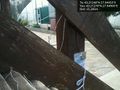
Just at the entrance of a tennis court in Varna.
Participants
Plans
Today I checked where is the nearest hash and since it was in the city and I had plans to go to some other places I decided to go visit :)
Expedition
Nothing fancy. Just drove there, took some pictures and returned home. On the sat picture you see the courts but in reality they were covered with inflatable bubbles so to be usable in the winter.
Photos
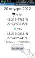
Geohash card. @43.2127,27.9496
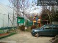
Playground. @43.2127,27.9496

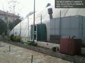
Obligatory :) @43.2127,27.9496
The hash... @43.2125,27.9494
Proof. @43.2134,27.9493


