Difference between revisions of "2012-01-20 58 12"
imported>Cjk ([retro picture] Trying to find the way back) |
imported>Cjk |
||
| Line 1: | Line 1: | ||
| − | |||
| − | [[Image:{{{image| | + | [[Image:{{{image|}}}|thumb|left]] |
| − | |||
| − | |||
| − | |||
| − | |||
| − | |||
{{meetup graticule | {{meetup graticule | ||
| lat=58 | | lat=58 | ||
| Line 20: | Line 14: | ||
== Participants == | == Participants == | ||
| − | + | <!-- who attended --> | |
| − | + | [[User:Cjk|Carl-Johan]] | |
== Plans == | == Plans == | ||
<!-- what were the original plans --> | <!-- what were the original plans --> | ||
| + | Check out the driven route google maps [https://maps.google.com/maps?saddr=Unknown+road&daddr=59.212477849568,17.949532351249+to:59.2251414,17.940631+to:58.212477849568,14.949532351249+to:58.22327,14.9481+to:58.261201,14.960958+to:58.212477849568,13.949532351249+to:58.41773,13.46604+to:58.212477849568,12.949532351249+to:58.212477849568,11.949532351249+to:Gamla+Almedalsv%C3%A4gen,+G%C3%B6teborg,+Sverige&hl=en&ie=UTF8&ll=58.967004,14.72168&spn=2.764406,7.064209&sll=58.322472,13.927917&sspn=0.703866,1.766052&geocode=FaBViQMdPPYSAQ%3BFb6ChwMdXOMRAQ%3BFTW0hwMdl8ARASk_Ue4L4HBfRjGg8H0Y8_4AEw%3BFX5AeAMdnBzkAA%3BFaZqeAMdBBfkACmxoQVAyixaRjGhZ9QX8_4AEw%3BFdH-eAMdPknkACmRNKuwEdNbRjGwLtQX8_4AEw%3BFX5AeAMdXNrUAA%3BFUJiewMduHnNAClbsR387B9bRjFB3dMIeJABEw%3BFX5AeAMdHJjFAA%3BFX5AeAMd3FW2AA%3BFW08cAMd9Ri3ACmnXh_PovNPRjFVaq2VXx8y7g&vpsrc=6&mra=dvme&mrsp=7&sz=9&via=2,4,5,7&t=h&z=7 here]! | ||
| + | |||
| + | Since I was going down to Onsala for my mom's 65th birthday anyway this weekend, why not try to get some [[Virgin Graticule|virgin graticules]] on the way down. And what do you know, 5 of them lined up next to great roads like E4, 26, 193, 46, 47, E20 and E6. This time, going East-West was going to be easy. And three of them were virgins! Time to deflower. | ||
| − | + | *[[2012-01-20 59 17]] | |
| + | *[[2012-01-20 58 14]] Virgin [[Tranås, Sweden]] | ||
| + | *[[2012-01-20 58 13]] Virgin [[Skövde, Sweden]] | ||
| + | *[[2012-01-20 58 12]] | ||
| + | *[[2012-01-20 58 11]] Virgin [[Uddevalla, Sweden]] | ||
| + | |||
== Expedition == | == Expedition == | ||
<!-- how it all turned out. your narrative goes here. --> | <!-- how it all turned out. your narrative goes here. --> | ||
| + | After coming from [[2012-01-20 58 13]] I did not take the shortest route via 193 and 47, but I took the road through Skövde and Skara to Götene Bildemo and bought my brake caliper. Now I can fix the right rear break next week. Then a quick 2 cheeseburgers at McDonkeys Drive Thru in Skara and then towards Vara. | ||
| + | |||
| + | No trouble finding the dirt road and the hash was just 40 or so meters from the road. BUT! | ||
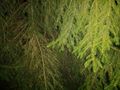
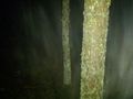
| − | + | I realize I had forgotten the flashlight I bought for my Ultra Hash back in Stockholm, and this location is the blackest you can imagine. Just super tall pines, no major city around, no streetlights within several km, no light polution at all, no stars because of clouds! It is pitch black! I use the glow from the phone to try to find my way but I can only see as far as the end of my arm. And the long trunks are messing with the GPS so it is super super slow again. The point might be inside a tree. I'm close enough and the tree is very wet and it is just above freezing som I'm not gonna hug it. 2m from the spot and this spot is done. | |
| + | This darkness is scary dark. So I stumble back towards the car. | ||
| − | + | Onwards towards to [[2012-01-20 58 11]]! | |
| + | *Complete darkness -- [[User:Cjk|Carl-Johan]] [http://www.openstreetmap.org/?lat=58.21242033&lon=12.94941863&zoom=16&layers=B000FTF @58.2124,12.9494] 11:50, 20 January 2012 (EST) | ||
| − | |||
| − | |||
== Photos == | == Photos == | ||
| Line 45: | Line 50: | ||
<gallery perrow="5"> | <gallery perrow="5"> | ||
| − | Image:2012-01-20_58_12_17-55-15-231.jpg | La Phaze [http://www.openstreetmap.org/?lat=58.21259233&lon=12.94936918&zoom=16&layers=B000FTF @58.2126,12.9494] | + | Image:2012-01-20_58_12_17-55-15-231.jpg | [http://www.laphaze.com/ La Phaze] [http://www.openstreetmap.org/?lat=58.21259233&lon=12.94936918&zoom=16&layers=B000FTF @58.2126,12.9494] |
Image:2012-01-20_58_12_20-30-49-914.jpg | Total darkness [http://www.openstreetmap.org/?lat=57.38508920&lon=11.99480470&zoom=16&layers=B000FTF @57.3851,11.9948] | Image:2012-01-20_58_12_20-30-49-914.jpg | Total darkness [http://www.openstreetmap.org/?lat=57.38508920&lon=11.99480470&zoom=16&layers=B000FTF @57.3851,11.9948] | ||
| Line 68: | Line 73: | ||
<!-- =============== USEFUL CATEGORIES FOLLOW ================ | <!-- =============== USEFUL CATEGORIES FOLLOW ================ | ||
Delete the next line ONLY if you have chosen the appropriate categories below. If you are unsure, don't worry. People will read your report and help you with the classification. --> | Delete the next line ONLY if you have chosen the appropriate categories below. If you are unsure, don't worry. People will read your report and help you with the classification. --> | ||
| − | |||
[[Category:Expeditions]] | [[Category:Expeditions]] | ||
Revision as of 22:15, 21 January 2012
[[Image:|thumb|left]]
| Fri 20 Jan 2012 in 58,12: 58.2124778, 12.9495324 geohashing.info google osm bing/os kml crox |
Location
Somewhere Notyh
Participants
Plans
Check out the driven route google maps here!
Since I was going down to Onsala for my mom's 65th birthday anyway this weekend, why not try to get some virgin graticules on the way down. And what do you know, 5 of them lined up next to great roads like E4, 26, 193, 46, 47, E20 and E6. This time, going East-West was going to be easy. And three of them were virgins! Time to deflower.
- 2012-01-20 59 17
- 2012-01-20 58 14 Virgin Tranås, Sweden
- 2012-01-20 58 13 Virgin Skövde, Sweden
- 2012-01-20 58 12
- 2012-01-20 58 11 Virgin Uddevalla, Sweden
Expedition
After coming from 2012-01-20 58 13 I did not take the shortest route via 193 and 47, but I took the road through Skövde and Skara to Götene Bildemo and bought my brake caliper. Now I can fix the right rear break next week. Then a quick 2 cheeseburgers at McDonkeys Drive Thru in Skara and then towards Vara.
No trouble finding the dirt road and the hash was just 40 or so meters from the road. BUT!
I realize I had forgotten the flashlight I bought for my Ultra Hash back in Stockholm, and this location is the blackest you can imagine. Just super tall pines, no major city around, no streetlights within several km, no light polution at all, no stars because of clouds! It is pitch black! I use the glow from the phone to try to find my way but I can only see as far as the end of my arm. And the long trunks are messing with the GPS so it is super super slow again. The point might be inside a tree. I'm close enough and the tree is very wet and it is just above freezing som I'm not gonna hug it. 2m from the spot and this spot is done.
This darkness is scary dark. So I stumble back towards the car.
Onwards towards to 2012-01-20 58 11!
- Complete darkness -- Carl-Johan @58.2124,12.9494 11:50, 20 January 2012 (EST)
Photos

Total darkness @57.3851,11.9948

Total darkness

Can't even see the camera
Spot
Or was it in the tree?
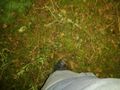
Trying to find the way back


Achievements
- Land geohash