Difference between revisions of "2012-01-26 57 13"
imported>Cjk ([live picture] Stupid grin) |
m (per Renaming Proposal) |
||
| (11 intermediate revisions by 3 users not shown) | |||
| Line 1: | Line 1: | ||
| + | [[Image:{{{image|2012-01-26_57_13_22-37-16-195.jpg}}}|thumb|left]] | ||
| − | |||
| − | |||
| − | |||
| − | |||
| − | |||
| − | |||
| − | |||
| − | |||
| − | |||
{{meetup graticule | {{meetup graticule | ||
| lat=57 | | lat=57 | ||
| Line 19: | Line 11: | ||
== Location == | == Location == | ||
<!-- where you've surveyed the hash to be --> | <!-- where you've surveyed the hash to be --> | ||
| + | In the woods between Ullared and Värnamo, not far from a logging road. | ||
== Participants == | == Participants == | ||
<!-- who attended --> | <!-- who attended --> | ||
| + | [[User:Cjk|Carl-Johan]] | ||
== Plans == | == Plans == | ||
<!-- what were the original plans --> | <!-- what were the original plans --> | ||
| + | To deflower 2 [[Virgin Graticule|virgin graticules]] and maybe work on my minesweeper around [[Västerås, Sweden]] making this a triple hash. [https://maps.google.com/maps?saddr=R%C3%B6san,+Onsala,+Sverige&daddr=57.0735521,13.0477922+to:57.0662319,13.0887601+to:57.0763577,+13.0874229+to:57.056284,13.118041+to:57.1214,13.37995+to:57.160525,13.414299+to:57.0763577,+14.0874229+to:57.16294,14.07451+to:57.1613372,14.0773533+to:59.0763577,+16.0874229+to:59.0775361,16.0880843+to:59.34386,18.02204+to:Grevgatan,+Stockholm,+Sverige&hl=en&ie=UTF8&sll=59.328636,18.058434&sspn=0.066288,0.138359&geocode=FR_EawMdk0S3ACl_kVeG48JPRjFccDXFdAjuUQ%3BFZDfZgMd8BfHACmV9GpE5lFQRjE-1NTvvNnPfA%3BFffCZgMd-LfHACm_Mpbbm1FQRjHQ0VYIeJABEw%3BFYbqZgMdv7LHAA%3BFRycZgMdWSrIACkHL2PwZFFQRjHQ61YIeJABEw%3BFXiaZwMdbinMAClVKHlCjfdQRjF8eynGy3MXBg%3BFU0zaAMdm6_MAClPFQ4xTvZQRjGRkXQIeJABEw%3BFYbqZgMd__TWAA%3BFbw8aAMdjsLWACmR1ActLMFQRjHQTrYQeJABEw%3BFXk2aAMdqc3WAClDxLtgLcFQRjFl23agI1wTvA%3BFQZvhQMdf3n1AA%3BFaBzhQMdFHz1ACkv-D07srteRjGh9GEX8_4AEw%3BFfSDiQMdmP4SASlRP348g51fRjESIXBrWHzwFg%3BFUZjiQMdSvcTASl78vQbUJ1fRjFt09J_yehrdw&oq=R%C3%B6san+onsala&mra=dpe&mrsp=12&sz=13&via=1,2,4,5,6,8,9,11,12&t=m&z=13 This] was the route I took. | ||
| + | |||
| + | *[[2012-01-26 57 13]] Virgin Graticule for [[Gislaved, Sweden]] | ||
| + | *[[2012-01-26 57 14]] Virgin Graticule for [[Jönköping, Sweden]] | ||
| + | *[[2012-01-26 59 16]] | ||
| + | |||
== Expedition == | == Expedition == | ||
<!-- how it all turned out. your narrative goes here. --> | <!-- how it all turned out. your narrative goes here. --> | ||
| + | I was due to go back from my mom to Stockholm and I picked a nice day to deflower two virgins on the way. The hash was really far west and that meant that [[2012-01-26 57 14]] would be close to the E4 and the latitude was pretty close to the 153 going past Ullared and Värnamo. Packed the car in the morning and drove off. It was just below freezing but sunny so mirror aviators on while going south on the E6. The 153 was pretty empty so I made good time. Saw some strange place names on the way, like ''Kalv'' (Calf). | ||
| + | |||
| + | Took a right on the road named Cykelspåret (the bike track) by the frozen lake Fegen and drove past the point until google told me to go left. This road was of course super tiny and covered with 10 cm of fresh snow. Nice and soft. Drove past some farm houses and took the wrong logging road 2 times before I found the correct one. These roads took me to around 149 m from the hash. Stopped the car at the highest point, as not to get stuck and got out and created some yellow snow in xkcd form. Saw two moose tracks right next to the car and the moose must know where the hash is so I followed them onto a clear cut down a hill. | ||
| + | |||
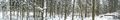
| + | Jumped over a creek. Saw a very lonely birch tree. Headed towards the woods and had to jump another creek. The woods where pretty old and high spruce so it was easy to walk in compared to the uneven and snowy clear cut before, but all the high trees started messing with GPS coverage so it stopped updating when I was 49 meters away. I kept walking for about 49 m, and then all of a sudden it updated and now I was 17 m due south of it, so I turned 90 degrees and walked to where I thought the hash was. But no updates. I circled around and pointed the phone to the skies. Took some pictures. Looked at the scenery. 10 minutes later I get a signal! And it turns out I had walked right past the hash a few meters back. Stopped there and took a panorama. | ||
| + | |||
| + | Tried to post a message but the data connection was too bad so I just got errors. You can see something in my contributions but not the actual message. | ||
| + | |||
| + | Then I try to send a picture so there would be some proof. Had to try and point the phone in all different directions again and with some good mojo it was uploaded. | ||
| − | + | Headed back to the car cause I was starting to freeze. Then off to Värnamo and [[2012-01-26 57 14]]. | |
| − | |||
== Photos == | == Photos == | ||
| Line 51: | Line 59: | ||
Image:2012-01-26_57_13_22-36-24-770.jpg | Stupid grin | Image:2012-01-26_57_13_22-36-24-770.jpg | Stupid grin | ||
| + | |||
| + | Image:2012-01-26_57_13_22-37-16-195.jpg | [http://www.nomeanswhatever.com/ Nomeansno], [https://en.wikipedia.org/wiki/All_Roads_Lead_to_Ausfahrt all roads leads to ausfart]. | ||
| + | |||
| + | Image:2012-01-26_57_13_22-37-47-174.jpg | The spot | ||
| + | |||
| + | Image:2012-01-26_57_13_22-40-21-840.jpg | Panorama 1 | ||
| + | |||
| + | Image:2012-01-26 57 13 13-00-35-303.jpg | Panorama 2 with proof | ||
</gallery> | </gallery> | ||
| Line 56: | Line 72: | ||
{{#vardefine:ribbonwidth|800px}} | {{#vardefine:ribbonwidth|800px}} | ||
<!-- Add any achievement ribbons you earned below, or remove this section --> | <!-- Add any achievement ribbons you earned below, or remove this section --> | ||
| + | {{land geohash | latitude = 57 | longitude = 13 | date = 2012-01-26 | name = [[User:Cjk|Carl-Johan]] }} | ||
| + | {{Frozen Geohash | latitude = 57 | longitude = 13 | date = 2012-01-26 | name = [[User:Cjk|Carl-Johan]] }} | ||
| + | {{graticule unlocked | latitude = 57 | longitude = 13 | date = 2012-01-26 | name = [[User:Cjk|Carl-Johan]] | image = 2012-01-26_57_13_22-37-16-195.jpg }} | ||
| + | {{Multihash2 | count = 3 | date = 2012-01-26 | name = [[User:Cjk|Carl-Johan]] }} | ||
| + | {{Minesweeper geohash | graticule = Västerås, Sweden | ranknumber = 6 | ne = true | e = true | se = true | s = true | sw = true | w = true | name = [[User:Cjk|Carl-Johan]] }} | ||
| + | {{Minesweeper geohash | graticule = Uppsala, Sweden | ranknumber = 6 | n = true | ne = true | e = true | s = true | sw = true | w = true | name = [[User:Cjk|Carl-Johan]] }} | ||
| + | [[Category:Expeditions]] | ||
| − | |||
| − | |||
| − | |||
| − | |||
| − | |||
| − | |||
| − | |||
| − | |||
| − | |||
| − | |||
| − | |||
| − | |||
[[Category:Expeditions with photos]] | [[Category:Expeditions with photos]] | ||
| − | |||
| − | |||
| − | |||
| − | |||
[[Category:Coordinates reached]] | [[Category:Coordinates reached]] | ||
| − | + | {{location|SE|N}} | |
| − | |||
| − | |||
| − | |||
| − | |||
| − | |||
| − | |||
| − | |||
| − | |||
| − | |||
Latest revision as of 05:46, 20 March 2024

| Thu 26 Jan 2012 in 57,13: 57.0763577, 13.0874229 geohashing.info google osm bing/os kml crox |
Location
In the woods between Ullared and Värnamo, not far from a logging road.
Participants
Plans
To deflower 2 virgin graticules and maybe work on my minesweeper around Västerås, Sweden making this a triple hash. This was the route I took.
- 2012-01-26 57 13 Virgin Graticule for Gislaved, Sweden
- 2012-01-26 57 14 Virgin Graticule for Jönköping, Sweden
- 2012-01-26 59 16
Expedition
I was due to go back from my mom to Stockholm and I picked a nice day to deflower two virgins on the way. The hash was really far west and that meant that 2012-01-26 57 14 would be close to the E4 and the latitude was pretty close to the 153 going past Ullared and Värnamo. Packed the car in the morning and drove off. It was just below freezing but sunny so mirror aviators on while going south on the E6. The 153 was pretty empty so I made good time. Saw some strange place names on the way, like Kalv (Calf).
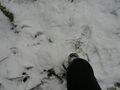
Took a right on the road named Cykelspåret (the bike track) by the frozen lake Fegen and drove past the point until google told me to go left. This road was of course super tiny and covered with 10 cm of fresh snow. Nice and soft. Drove past some farm houses and took the wrong logging road 2 times before I found the correct one. These roads took me to around 149 m from the hash. Stopped the car at the highest point, as not to get stuck and got out and created some yellow snow in xkcd form. Saw two moose tracks right next to the car and the moose must know where the hash is so I followed them onto a clear cut down a hill.
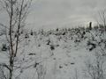
Jumped over a creek. Saw a very lonely birch tree. Headed towards the woods and had to jump another creek. The woods where pretty old and high spruce so it was easy to walk in compared to the uneven and snowy clear cut before, but all the high trees started messing with GPS coverage so it stopped updating when I was 49 meters away. I kept walking for about 49 m, and then all of a sudden it updated and now I was 17 m due south of it, so I turned 90 degrees and walked to where I thought the hash was. But no updates. I circled around and pointed the phone to the skies. Took some pictures. Looked at the scenery. 10 minutes later I get a signal! And it turns out I had walked right past the hash a few meters back. Stopped there and took a panorama.
Tried to post a message but the data connection was too bad so I just got errors. You can see something in my contributions but not the actual message.
Then I try to send a picture so there would be some proof. Had to try and point the phone in all different directions again and with some good mojo it was uploaded.
Headed back to the car cause I was starting to freeze. Then off to Värnamo and 2012-01-26 57 14.
Photos
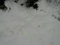
Yellow Snow. Do not eat!
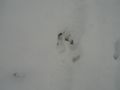
Moose tracks
Geohash in those woods
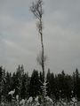
A lone birch tree

Scetchy
The way back

Stupid grin
The spot
Panorama 1
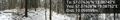
Panorama 2 with proof


Achievements
Carl-Johan earned the Land geohash achievement
|

Carl-Johan earned the Graticule Unlocked Achievement
|
Carl-Johan earned the Multihash Achievement
|
Carl-Johan achieved level 6 of the Minesweeper Geohash achievement
|
Carl-Johan achieved level 6 of the Minesweeper Geohash achievement
|